Property Record
Vado Dr, Vado, NM 88072
NEARBY LISTINGS FOR SALE OR LEASE
Property Detail
Vado Dr
17-04140
S: 21 T: 25S R: 3E POR NWQTR
Vacantlandnec
Dona Ana
X
New Mexico
35013C1525G
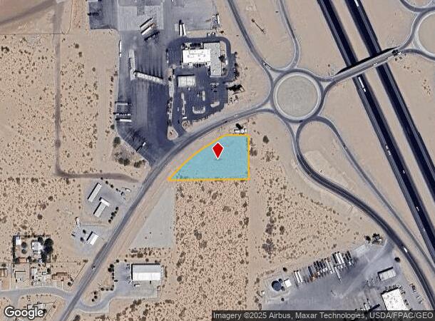
1.23 AC
2024
Las Cruces/Alamogordo
2025
Other Market Areas
001812
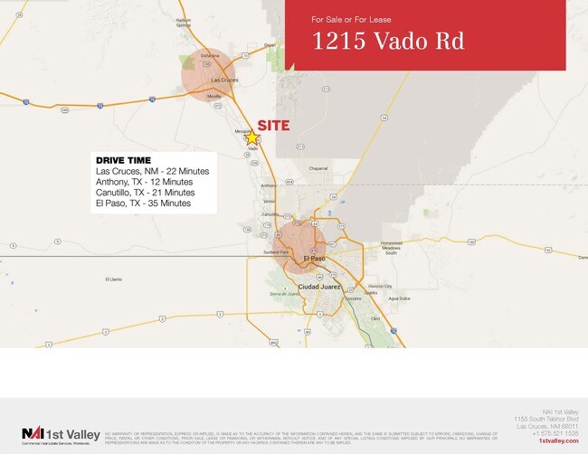
Las Cruces, NM
DEMOGRAPHICS near Vado Dr
1 Mile
3 Mile
5 Mile
2024 Total Population
545
2,984
7,003
2029 Population
530
2,922
6,958
Pop Growth 2024-2029
(2.75%)
(2.08%)
(0.64%)
Average Age
35
36
36
2024 Total Households
166
905
2,204
HH Growth 2024-2029
(2.41%)
(1.99%)
(0.68%)
Median Household Inc
$37,352
$40,278
$38,272
Avg Household Size
3.10
3.10
3.00
2024 Avg HH Vehicles
3.00
2.00
2.00
Median Home Value
$95,832
$121,726
$107,609
Median Year Built
1981
1983
1985
Nearby Places
Map Layers
Map Styles
 Street
 Aerial
- Restaurants
- Banks
- Shops
- Fitness
- Groceries
PUBLIC TRANSPORTATION
AIRPORT
El Paso International
DRIVE
WALK
Distance
El Paso International
54 min
38.3 mi
Freight Ports
Port of San Diego
DRIVE
WALK
Distance
Port of San Diego
728 min
696.7 mi
SALE & LEASE HISTORY
LISTING DATE
SALE/LEASE

Dec 06, 2021
For Sale
Nearby Properties
Address
Land Use
TOTAL SIZE
Lot Size
Zoning
Address
Land Use
TOTAL SIZE
Lot Size
Zoning
189,490 SF
100 AC
I3
Address
Land Use
TOTAL SIZE
Lot Size
Zoning
288,487 SF
575.79 AC
T2
Address
Land Use
TOTAL SIZE
Lot Size
Zoning
32,751 SF
160 AC
T2
Address
Land Use
TOTAL SIZE
Lot Size
Zoning
21,762 SF
10 AC
C3
Address
Land Use
TOTAL SIZE
Lot Size
Zoning
20,200 SF
7.50 AC
A2
Address
Land Use
TOTAL SIZE
Lot Size
Zoning
30,471 SF
10.87 AC
I3
Address
Land Use
TOTAL SIZE
Lot Size
Zoning
16,205 SF
6.27 AC
C3
Address
Land Use
TOTAL SIZE
Lot Size
Zoning
9,065 SF
1.47 AC
C1
Address
Land Use
TOTAL SIZE
Lot Size
Zoning
7,201 SF
1.04 AC
C1
Address
Land Use
TOTAL SIZE
Lot Size
Zoning
7,848 SF
1.46 AC
MU
Address
Land Use
TOTAL SIZE
Lot Size
Zoning
91.91 AC
T2
Address
Land Use
TOTAL SIZE
Lot Size
Zoning
228,497 SF
72.86 AC
I2
Address
Land Use
TOTAL SIZE
Lot Size
Zoning
13.84 AC
C1
Address
Land Use
TOTAL SIZE
Lot Size
Zoning
5,000 SF
388.90 AC
I3
Address
Land Use
TOTAL SIZE
Lot Size
Zoning
97,515 SF
35.54 AC
I2
Address
Land Use
TOTAL SIZE
Lot Size
Zoning
2,946 SF
2 AC
T3
Address
Land Use
TOTAL SIZE
Lot Size
Zoning
3,944 SF
1.81 AC
T3
Address
Land Use
TOTAL SIZE
Lot Size
Zoning
7,057 SF
1 AC
D1-L
Address
Land Use
TOTAL SIZE
Lot Size
Zoning
11.34 AC
C1
Address
Land Use
TOTAL SIZE
Lot Size
Zoning
8,000 SF
4.98 AC
MU
Address
Land Use
TOTAL SIZE
Lot Size
Zoning
5,084 SF
0.88 AC
C1
Address
Land Use
TOTAL SIZE
Lot Size
Zoning
1,458 SF
325 AC
T2
Address
Land Use
TOTAL SIZE
Lot Size
Zoning
3,767 SF
19.50 AC
R5-L
Address
Land Use
TOTAL SIZE
Lot Size
Zoning
36,809 SF
2.63 AC
MU
Address
Land Use
TOTAL SIZE
Lot Size
Zoning
2,080 SF
1 AC
C3
Address
Land Use
TOTAL SIZE
Lot Size
Zoning
142.98 AC
R5
Address
Land Use
TOTAL SIZE
Lot Size
Zoning
4,500 SF
2 AC
C1
Address
Land Use
TOTAL SIZE
Lot Size
Zoning
3,372 SF
1 AC
D2
Address
Land Use
TOTAL SIZE
Lot Size
Zoning
2,760 SF
2.58 AC
T3
Address
Land Use
TOTAL SIZE
Lot Size
Zoning
2,852 SF
5.13 AC
R5
The World's #1 Commercial Real Estate Marketplace
Connect with us
© 2026 CoStar Group
The information above has been obtained from sources believed reliable. While we do not doubt its accuracy we have not verified it and make no guarantee, warranty or representation about it. It is your responsibility to independently confirm its accuracy and completeness. Any projections, opinions, assumptions, or estimates used are for example only and do not represent the current or future performance of the property. The value of this transaction to you depends on tax and other factors which should be evaluated by your tax, financial, and legal advisors. You and your advisors should conduct a careful, independent investigation of the property to determine to your satisfaction the suitability of the property for your needs.