Property Record
Interstate 30, Little Rock, AR 72210

Property Detail
Interstate 30
Little Rock-North Little Rock-Conway, AR
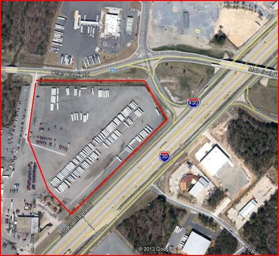
PT NW SECTION 9-1S-13 LYING W OF I-30 & S OF OTTER CREEK RD COM AT THE NW CORNER OF THE NW THENCE S89*28'25E273.21' ALONG THE NORTH LINE OF SECTION 9 TO THE POB THENCE S89*28'25"E260' S24?45'07"E289.82'' S45*33'53"W224.17'' S45*42'17"E470.15' S4
45L-056-00-011-00
PULASKI
Commercialacreage
Arkansas
AE The base floodplain where base flood elevations are provided. AE Zones are now used on new format FIRMs instead of A1-A30 Zones.
7.44 AC
2025
Outlying Pulaski County
2025
Little Rock/N Little Rock
004227
NEARBY LISTINGS FOR SALE OR LEASE
-
-
-
-
-
-
No Photo
-
-
View all Little Rock listings for sale on LoopNet.com
DEMOGRAPHICS near Interstate 30
1 mile
3 mile
5 mile
2025 Total Population
1,412
26,458
74,153
2030 Population
1,380
26,810
75,674
Pop Growth 2025-2030
(2.27%)
+ 1.33%
+ 2.05%
Average Age
39
37
37
2025 Total Households
592
10,499
28,781
HH Growth 2025-2030
(2.20%)
+ 1.24%
+ 1.98%
Median Household Inc
$67,678
$57,778
$60,289
Avg Household Size
2.30
2.50
2.50
2025 Avg HH Vehicles
2.00
2.00
2.00
Median Home Value
$218,788
$186,677
$181,151
Median Year Built
1994
1992
1988
Nearby Places
Map Layers
Map Styles
 Street
 Aerial
Layers
 Traffic
 Biking
Places
Listings with unknown addresses are not visible on the map
- Restaurants
- Banks
- Shops
- Fitness
- Groceries
PUBLIC TRANSPORTATION
AIRPORT
Bill and Hillary Clinton Ntl/Adams Field
Drive
Walk
Distance
Bill and Hillary Clinton Ntl/Adams Field
20 min
14.8 mi
Freight Ports
Port of Shreveport
Drive
Walk
Distance
Port of Shreveport
236 min
221.5 mi
SALE & LEASE HISTORY
LISTING DATE
SALE/LEASE

Sep 24, 2016
For Sale
Jul 03, 2017
For Sale
Nearby Properties
Address
Land Use
TOTAL SIZE
Lot Size
Zoning
Address
Land Use
TOTAL SIZE
Lot Size
Zoning
189,729 SF
57.75 AC
Address
Land Use
TOTAL SIZE
Lot Size
Zoning
177,413 SF
35.78 AC
Address
Land Use
TOTAL SIZE
Lot Size
Zoning
185,805 SF
8.29 AC
Address
Land Use
TOTAL SIZE
Lot Size
Zoning
317,302 SF
44.38 AC
Address
Land Use
TOTAL SIZE
Lot Size
Zoning
26,199 SF
19.22 AC
Address
Land Use
TOTAL SIZE
Lot Size
Zoning
201,039 SF
146.98 AC
Address
Land Use
TOTAL SIZE
Lot Size
Zoning
13,888 SF
21.57 AC
Address
Land Use
TOTAL SIZE
Lot Size
Zoning
83,022 SF
6.20 AC
Address
Land Use
TOTAL SIZE
Lot Size
Zoning
365,104 SF
29.75 AC
Address
Land Use
TOTAL SIZE
Lot Size
Zoning
104,359 SF
14.63 AC
Address
Land Use
TOTAL SIZE
Lot Size
Zoning
13,952 SF
12.35 AC
Address
Land Use
TOTAL SIZE
Lot Size
Zoning
7,937 SF
5.50 AC
Address
Land Use
TOTAL SIZE
Lot Size
Zoning
12,420 SF
12.25 AC
Address
Land Use
TOTAL SIZE
Lot Size
Zoning
201,499 SF
21.70 AC
Address
Land Use
TOTAL SIZE
Lot Size
Zoning
16,957 SF
6.04 AC
Address
Land Use
TOTAL SIZE
Lot Size
Zoning
8,510 SF
13.20 AC
Address
Land Use
TOTAL SIZE
Lot Size
Zoning
45,600 SF
6.45 AC
Address
Land Use
TOTAL SIZE
Lot Size
Zoning
189,160 SF
40.53 AC
Address
Land Use
TOTAL SIZE
Lot Size
Zoning
30,356 SF
5.42 AC
Address
Land Use
TOTAL SIZE
Lot Size
Zoning
71,581 SF
10.69 AC
Address
Land Use
TOTAL SIZE
Lot Size
Zoning
11,762 SF
9.05 AC
Address
Land Use
TOTAL SIZE
Lot Size
Zoning
309,271 SF
41.75 AC
Address
Land Use
TOTAL SIZE
Lot Size
Zoning
7,482 SF
6.58 AC
Address
Land Use
TOTAL SIZE
Lot Size
Zoning
7,950 SF
8.74 AC
Address
Land Use
TOTAL SIZE
Lot Size
Zoning
19,440 SF
23.16 AC
Address
Land Use
TOTAL SIZE
Lot Size
Zoning
6,282 SF
61.51 AC
Address
Land Use
TOTAL SIZE
Lot Size
Zoning
162,970 SF
12.66 AC
Address
Land Use
TOTAL SIZE
Lot Size
Zoning
26,864 SF
7.95 AC
Address
Land Use
TOTAL SIZE
Lot Size
Zoning
11,794 SF
5.45 AC
Address
Land Use
TOTAL SIZE
Lot Size
Zoning
20,440 SF
5.61 AC
The World's #1 Commercial Real Estate Marketplace
Connect with us
© 2026 CoStar Group
The information above has been obtained from sources believed reliable. While we do not doubt its accuracy we have not verified it and make no guarantee, warranty or representation about it. It is your responsibility to independently confirm its accuracy and completeness. Any projections, opinions, assumptions, or estimates used are for example only and do not represent the current or future performance of the property. The value of this transaction to you depends on tax and other factors which should be evaluated by your tax, financial, and legal advisors. You and your advisors should conduct a careful, independent investigation of the property to determine to your satisfaction the suitability of the property for your needs.