Property Record
Interstate 35, Waxahachie, TX 75165
Current Lease Availabilities
NEARBY LISTINGS FOR SALE OR LEASE
Property Detail
Interstate 35
Dallas-Fort Worth-Arlington, TX
E C School Land
277753
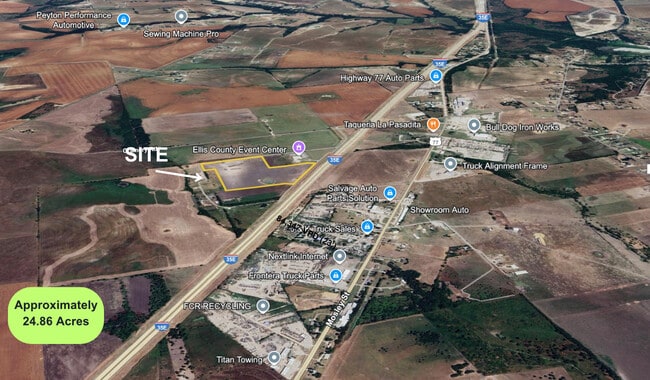
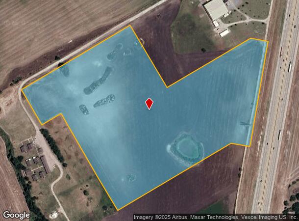
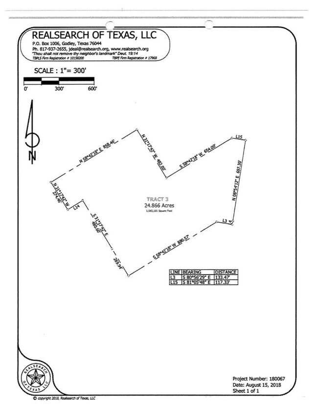
328 E C SCHOOL LAND LOCKED GATE 24.866 ACRES
Agriculturalland
Ellis
X
Texas
48139C0190G
24.87 AC
2024
Ellis County
2025
Dallas/Ft Worth
060300
DEMOGRAPHICS near Interstate 35
1 Mile
3 Mile
5 Mile
2024 Total Population
479
3,151
15,846
2029 Population
716
4,696
23,733
Pop Growth 2024-2029
+ 49.48%
+ 49.03%
+ 49.77%
Average Age
44
41
38
2024 Total Households
183
1,095
5,454
HH Growth 2024-2029
+ 50.27%
+ 49.50%
+ 50.24%
Median Household Inc
$67,031
$80,026
$71,859
Avg Household Size
2.50
2.80
2.80
2024 Avg HH Vehicles
2.00
2.00
2.00
Median Home Value
$434,615
$408,511
$388,687
Median Year Built
1999
1992
1999
Nearby Places
Map Layers
Map Styles
 Street
 Aerial
- Restaurants
- Banks
- Shops
- Fitness
- Groceries
Nearby Properties
Address
Land Use
TOTAL SIZE
Lot Size
Zoning
Address
Land Use
TOTAL SIZE
Lot Size
Zoning
Address
Land Use
TOTAL SIZE
Lot Size
Zoning
13,311 SF
273.96 AC
Address
Land Use
TOTAL SIZE
Lot Size
Zoning
31,441 SF
10.01 AC
Address
Land Use
TOTAL SIZE
Lot Size
Zoning
10,639 SF
161.43 AC
Address
Land Use
TOTAL SIZE
Lot Size
Zoning
98.15 AC
Address
Land Use
TOTAL SIZE
Lot Size
Zoning
19,062 SF
2.08 AC
Address
Land Use
TOTAL SIZE
Lot Size
Zoning
18,648 SF
3.60 AC
Address
Land Use
TOTAL SIZE
Lot Size
Zoning
10,000 SF
10 AC
Address
Land Use
TOTAL SIZE
Lot Size
Zoning
74.57 AC
Address
Land Use
TOTAL SIZE
Lot Size
Zoning
28,060 SF
10.35 AC
Address
Land Use
TOTAL SIZE
Lot Size
Zoning
18,680 SF
1.48 AC
Address
Land Use
TOTAL SIZE
Lot Size
Zoning
6,606 SF
60 AC
Address
Land Use
TOTAL SIZE
Lot Size
Zoning
7,534 SF
21.46 AC
Address
Land Use
TOTAL SIZE
Lot Size
Zoning
62,791 SF
14.65 AC
Address
Land Use
TOTAL SIZE
Lot Size
Zoning
22,950 SF
5 AC
Address
Land Use
TOTAL SIZE
Lot Size
Zoning
48,100 SF
17.47 AC
Address
Land Use
TOTAL SIZE
Lot Size
Zoning
15,000 SF
10.01 AC
Address
Land Use
TOTAL SIZE
Lot Size
Zoning
15,902 SF
10.88 AC
Address
Land Use
TOTAL SIZE
Lot Size
Zoning
Address
Land Use
TOTAL SIZE
Lot Size
Zoning
11,400 SF
5 AC
Address
Land Use
TOTAL SIZE
Lot Size
Zoning
2,800 SF
10.01 AC
Address
Land Use
TOTAL SIZE
Lot Size
Zoning
6,804 SF
80.42 AC
Address
Land Use
TOTAL SIZE
Lot Size
Zoning
8,750 SF
10.21 AC
Address
Land Use
TOTAL SIZE
Lot Size
Zoning
87.34 AC
Address
Land Use
TOTAL SIZE
Lot Size
Zoning
4,422 SF
17.35 AC
Address
Land Use
TOTAL SIZE
Lot Size
Zoning
290.49 AC
Address
Land Use
TOTAL SIZE
Lot Size
Zoning
7,584 SF
0.75 AC
Address
Land Use
TOTAL SIZE
Lot Size
Zoning
38.19 AC
Address
Land Use
TOTAL SIZE
Lot Size
Zoning
12,336 SF
5.28 AC
Address
Land Use
TOTAL SIZE
Lot Size
Zoning
1,760 SF
11.11 AC
The World's #1 Commercial Real Estate Marketplace
Connect with us
© 2026 CoStar Group
The information above has been obtained from sources believed reliable. While we do not doubt its accuracy we have not verified it and make no guarantee, warranty or representation about it. It is your responsibility to independently confirm its accuracy and completeness. Any projections, opinions, assumptions, or estimates used are for example only and do not represent the current or future performance of the property. The value of this transaction to you depends on tax and other factors which should be evaluated by your tax, financial, and legal advisors. You and your advisors should conduct a careful, independent investigation of the property to determine to your satisfaction the suitability of the property for your needs.