Property Record
3315 Sw 59Th St, Oklahoma City, OK 73119


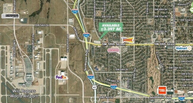
This Property Is For Sale
Property Detail
3315 Sw 59Th St
Oklahoma City, OK
ALMONTE ADD BLK 020 PT OF LOT 2 PLUS A PT OF S/2 OF SEC 24 11N 4W DESC AS BEG 409.05FT NW OF A 3/8 REBAR E/C OF TR 6 IN BK 3999 PG 73 ON S LINE OF SD LOT 2 TH NW273.02FT NW168.56FT NE332.57FT NELY ON CURVE 99.33FT SE364.12FT SE112.71FT SW393.58FT TO
141284440
OKLAHOMA
Commercialacreage
Oklahoma
SPUD
2
B and X Area of moderate flood hazard, usually the area between the limits of the 100-year and 500-year floods.
22.81 AC
2024
West/Central
2025
Oklahoma City
105500
NEARBY LISTINGS FOR SALE OR LEASE
DEMOGRAPHICS near 3315 Sw 59Th St
1 mile
3 mile
5 mile
2025 Total Population
14,149
92,602
170,494
2030 Population
14,342
94,402
174,258
Pop Growth 2025-2030
+ 1.36%
+ 1.94%
+ 2.21%
Average Age
34
35
36
2025 Total Households
4,813
32,537
61,742
HH Growth 2025-2030
+ 1.50%
+ 2.04%
+ 2.33%
Median Household Inc
$42,299
$48,405
$51,927
Avg Household Size
2.80
2.70
2.60
2025 Avg HH Vehicles
2.00
2.00
2.00
Median Home Value
$126,858
$135,426
$167,500
Median Year Built
1963
1965
1972
Nearby Places
Map Layers
Map Styles
 Street
 Aerial
Transit
 Traffic
 Biking
Places
Listings with unknown addresses are not visible on the map
- Restaurants
- Banks
- Shops
- Fitness
- Groceries
PUBLIC TRANSPORTATION
COMMUTER RAIL
Oklahoma City (Heartland Flyer - Amtrak)
Drive
Walk
Distance
Oklahoma City (Heartland Flyer - Amtrak)
11 min
8.0 mi
AIRPORT
Will Rogers World
Drive
Walk
Distance
Will Rogers World
9 min
3.0 mi
Freight Ports
Tulsa Port Of Catoosa
Drive
Walk
Distance
Tulsa Port Of Catoosa
143 min
130.9 mi
Nearby Properties
Address
Land Use
TOTAL SIZE
Lot Size
Zoning
Address
Land Use
TOTAL SIZE
Lot Size
Zoning
192.48 AC
Address
Land Use
TOTAL SIZE
Lot Size
Zoning
64,658 SF
1.86 AC
SPUD
Address
Land Use
TOTAL SIZE
Lot Size
Zoning
384,708 SF
17.05 AC
R-4
Address
Land Use
TOTAL SIZE
Lot Size
Zoning
Address
Land Use
TOTAL SIZE
Lot Size
Zoning
27,056 SF
40.77 AC
Address
Land Use
TOTAL SIZE
Lot Size
Zoning
232,037 SF
18.80 AC
C-3
Address
Land Use
TOTAL SIZE
Lot Size
Zoning
Address
Land Use
TOTAL SIZE
Lot Size
Zoning
239,760 SF
18.52 AC
PUD
Address
Land Use
TOTAL SIZE
Lot Size
Zoning
93,886 SF
8.57 AC
CO
Address
Land Use
TOTAL SIZE
Lot Size
Zoning
259,726 SF
19.94 AC
PUD
Address
Land Use
TOTAL SIZE
Lot Size
Zoning
39,734 SF
5.16 AC
C-3
Address
Land Use
TOTAL SIZE
Lot Size
Zoning
192,771 SF
11.20 AC
I-3
Address
Land Use
TOTAL SIZE
Lot Size
Zoning
11,850 SF
1.49 AC
R-2
Address
Land Use
TOTAL SIZE
Lot Size
Zoning
158,150 SF
15.18 AC
I-2
Address
Land Use
TOTAL SIZE
Lot Size
Zoning
192,405 SF
24.38 AC
Address
Land Use
TOTAL SIZE
Lot Size
Zoning
203,880 SF
9.93 AC
R-4
Address
Land Use
TOTAL SIZE
Lot Size
Zoning
7,496 SF
4.20 AC
Address
Land Use
TOTAL SIZE
Lot Size
Zoning
233,288 SF
24.24 AC
C-3
Address
Land Use
TOTAL SIZE
Lot Size
Zoning
124,208 SF
21.48 AC
I-2
Address
Land Use
TOTAL SIZE
Lot Size
Zoning
204,885 SF
23.47 AC
C-3
Address
Land Use
TOTAL SIZE
Lot Size
Zoning
66,705 SF
7.64 AC
RM
Address
Land Use
TOTAL SIZE
Lot Size
Zoning
198,631 SF
13.26 AC
C-3
Address
Land Use
TOTAL SIZE
Lot Size
Zoning
271,312 SF
13.06 AC
R-4
Address
Land Use
TOTAL SIZE
Lot Size
Zoning
235,670 SF
10.38 AC
R-4
Address
Land Use
TOTAL SIZE
Lot Size
Zoning
92,222 SF
6.40 AC
R-4
Address
Land Use
TOTAL SIZE
Lot Size
Zoning
164,114 SF
21.70 AC
I-3
Address
Land Use
TOTAL SIZE
Lot Size
Zoning
208,400 SF
11.28 AC
I-3
Address
Land Use
TOTAL SIZE
Lot Size
Zoning
151,392 SF
7.08 AC
R-4
Address
Land Use
TOTAL SIZE
Lot Size
Zoning
240,000 SF
12.01 AC
I-2
Address
Land Use
TOTAL SIZE
Lot Size
Zoning
201,236 SF
24.14 AC
R-4
The World's #1 Commercial Real Estate Marketplace
Connect with us
© 2026 CoStar Group
The information above has been obtained from sources believed reliable. While we do not doubt its accuracy we have not verified it and make no guarantee, warranty or representation about it. It is your responsibility to independently confirm its accuracy and completeness. Any projections, opinions, assumptions, or estimates used are for example only and do not represent the current or future performance of the property. The value of this transaction to you depends on tax and other factors which should be evaluated by your tax, financial, and legal advisors. You and your advisors should conduct a careful, independent investigation of the property to determine to your satisfaction the suitability of the property for your needs.