Property Record
Irving Rd, Bel Alton, MD 20611

Property Detail
Irving Rd
Washington-Arlington-Alexandria, DC-VA-MD-WV
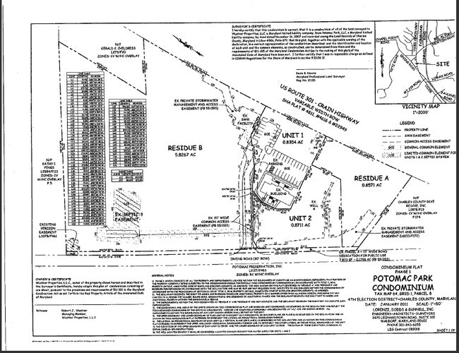
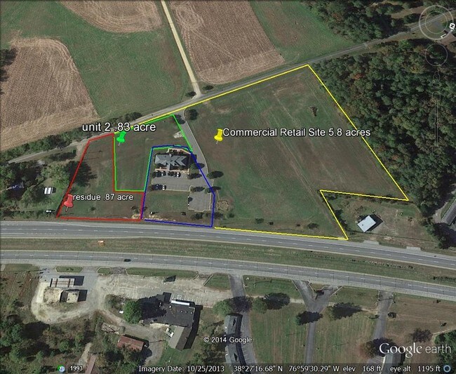
UNIT 2 0.8711 AC PLA
04-351147
CHARLES
Commercialcondominium
Maryland
CV
2
B and X Area of moderate flood hazard, usually the area between the limits of the 100-year and 500-year floods.
0.86 AC
2025
Charles County
2025
Washington, DC
851100
NEARBY LISTINGS FOR SALE OR LEASE
DEMOGRAPHICS near Irving Rd
1 mile
3 mile
5 mile
2025 Total Population
513
1,902
11,029
2030 Population
521
1,938
11,432
Pop Growth 2025-2030
+ 1.56%
+ 1.89%
+ 3.65%
Average Age
43
43
42
2025 Total Households
186
686
3,980
HH Growth 2025-2030
+ 1.61%
+ 1.90%
+ 3.79%
Median Household Inc
$119,642
$123,450
$122,164
Avg Household Size
2.70
2.70
2.70
2025 Avg HH Vehicles
3.00
3.00
2.00
Median Home Value
$485,897
$485,270
$462,085
Median Year Built
1976
1976
1987
Nearby Places
Map Layers
Map Styles
 Street
 Aerial
Layers
 Traffic
 Biking
Places
Listings with unknown addresses are not visible on the map
- Restaurants
- Banks
- Shops
- Fitness
- Groceries
PUBLIC TRANSPORTATION
AIRPORT
Ronald Reagan Washington Ntl
Drive
Walk
Distance
Ronald Reagan Washington Ntl
65 min
40.9 mi
Freight Ports
Port of Baltimore
Drive
Walk
Distance
Port of Baltimore
100 min
67.7 mi
SALE & LEASE HISTORY
LISTING DATE
SALE/LEASE

May 23, 2019
For Sale
Nearby Properties
Address
Land Use
TOTAL SIZE
Lot Size
Zoning
Address
Land Use
TOTAL SIZE
Lot Size
Zoning
1,350 SF
820.92 AC
RC
Address
Land Use
TOTAL SIZE
Lot Size
Zoning
35,571 SF
100 AC
AC
Address
Land Use
TOTAL SIZE
Lot Size
Zoning
38,040 SF
12.76 AC
CV
Address
Land Use
TOTAL SIZE
Lot Size
Zoning
19,638 SF
4.84 AC
CV
Address
Land Use
TOTAL SIZE
Lot Size
Zoning
10.32 AC
RC
Address
Land Use
TOTAL SIZE
Lot Size
Zoning
30 AC
RC
Address
Land Use
TOTAL SIZE
Lot Size
Zoning
9,442 SF
28.36 AC
AC
Address
Land Use
TOTAL SIZE
Lot Size
Zoning
10,237 SF
25.52 AC
AC
Address
Land Use
TOTAL SIZE
Lot Size
Zoning
7,200 SF
3.88 AC
AC
Address
Land Use
TOTAL SIZE
Lot Size
Zoning
14,748 SF
9.40 AC
CV
Address
Land Use
TOTAL SIZE
Lot Size
Zoning
8,568 SF
6.80 AC
CV
Address
Land Use
TOTAL SIZE
Lot Size
Zoning
9,396 SF
62.43 AC
AC
Address
Land Use
TOTAL SIZE
Lot Size
Zoning
7,150 SF
2.84 AC
CV
Address
Land Use
TOTAL SIZE
Lot Size
Zoning
5,840 SF
0.84 AC
CV
Address
Land Use
TOTAL SIZE
Lot Size
Zoning
8,328 SF
2.08 AC
CV/AC
Address
Land Use
TOTAL SIZE
Lot Size
Zoning
35,244 SF
6.10 AC
RC
Address
Land Use
TOTAL SIZE
Lot Size
Zoning
11,042 SF
8.55 AC
RV
Address
Land Use
TOTAL SIZE
Lot Size
Zoning
9,353 SF
1.36 AC
CV
Address
Land Use
TOTAL SIZE
Lot Size
Zoning
2,888 SF
5.65 AC
RC
Address
Land Use
TOTAL SIZE
Lot Size
Zoning
4,716 SF
1.25 AC
CV
Address
Land Use
TOTAL SIZE
Lot Size
Zoning
3,360 SF
5 AC
AC
Address
Land Use
TOTAL SIZE
Lot Size
Zoning
4,427 SF
2.56 AC
RC
Address
Land Use
TOTAL SIZE
Lot Size
Zoning
3,321 SF
3.57 AC
AC
Address
Land Use
TOTAL SIZE
Lot Size
Zoning
4,851 SF
1.11 AC
RC
Address
Land Use
TOTAL SIZE
Lot Size
Zoning
3,968 SF
0.96 AC
CV
Address
Land Use
TOTAL SIZE
Lot Size
Zoning
4,628 SF
11.56 AC
AC
Address
Land Use
TOTAL SIZE
Lot Size
Zoning
3,497 SF
1.46 AC
AC
Address
Land Use
TOTAL SIZE
Lot Size
Zoning
4,318 SF
2.02 AC
RC
Address
Land Use
TOTAL SIZE
Lot Size
Zoning
3,152 SF
4.26 AC
CC
Address
Land Use
TOTAL SIZE
Lot Size
Zoning
2,452 SF
2.68 AC
IG
The World's #1 Commercial Real Estate Marketplace
Connect with us
© 2026 CoStar Group
The information above has been obtained from sources believed reliable. While we do not doubt its accuracy we have not verified it and make no guarantee, warranty or representation about it. It is your responsibility to independently confirm its accuracy and completeness. Any projections, opinions, assumptions, or estimates used are for example only and do not represent the current or future performance of the property. The value of this transaction to you depends on tax and other factors which should be evaluated by your tax, financial, and legal advisors. You and your advisors should conduct a careful, independent investigation of the property to determine to your satisfaction the suitability of the property for your needs.