Property Record
J St, Anniston, AL 36201
NEARBY LISTINGS FOR SALE OR LEASE
Property Detail
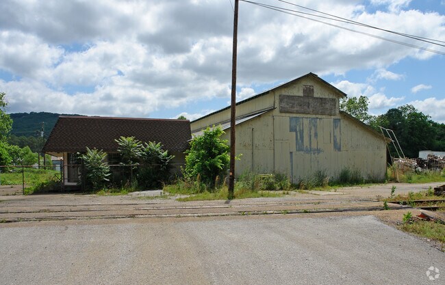
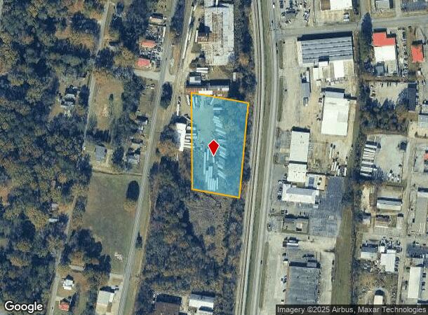
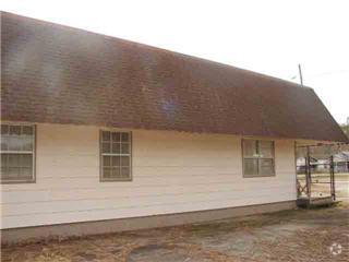
J St
Warehouse
SEC 17 T16S R08E BEG @ S R/W J ST & W R/W SOUTHERN RR SE 460 W 206 NW 460 TO S R/W J E ALG R/W 250 TO POB ANNISTON AL
AE
Calhoun
01015C0314E
Alabama
2025
2.40 AC
2025
Other Market Areas
000400
Anniston-Oxford, AL
6,100 SF
21-04-17-3-002-033.000
DEMOGRAPHICS near J St
1 Mile
3 Mile
5 Mile
2024 Total Population
3,027
24,856
46,363
2029 Population
3,042
24,850
45,965
Pop Growth 2024-2029
+ 0.50%
(0.02%)
(0.86%)
Average Age
39
42
42
2024 Total Households
1,140
10,450
19,177
HH Growth 2024-2029
+ 0.61%
(0.05%)
(0.91%)
Median Household Inc
$29,642
$37,624
$42,752
Avg Household Size
2.10
2.20
2.30
2024 Avg HH Vehicles
2.00
2.00
2.00
Median Home Value
$137,634
$105,026
$126,066
Median Year Built
1971
1970
1973
Nearby Places
Map Layers
Map Styles
 Street
 Aerial
- Restaurants
- Banks
- Shops
- Fitness
- Groceries
PUBLIC TRANSPORTATION
COMMUTER RAIL
Anniston Amtrak Station (Crescent - Amtrak)
DRIVE
WALK
Distance
Anniston Amtrak Station (Crescent - Amtrak)
2 min
1.1 mi
Freight Ports
Port of Panama City
DRIVE
WALK
Distance
Port of Panama City
361 min
291.2 mi
Nearby Properties
Address
Land Use
TOTAL SIZE
Lot Size
Zoning
Address
Land Use
TOTAL SIZE
Lot Size
Zoning
319,650 SF
10.69 AC
Address
Land Use
TOTAL SIZE
Lot Size
Zoning
12,496 SF
7.39 AC
Address
Land Use
TOTAL SIZE
Lot Size
Zoning
4,520 SF
8.20 AC
Address
Land Use
TOTAL SIZE
Lot Size
Zoning
73,027 SF
1.60 AC
Address
Land Use
TOTAL SIZE
Lot Size
Zoning
21,766 SF
3.06 AC
Address
Land Use
TOTAL SIZE
Lot Size
Zoning
5.32 AC
Address
Land Use
TOTAL SIZE
Lot Size
Zoning
18.90 AC
Address
Land Use
TOTAL SIZE
Lot Size
Zoning
1,972 SF
22.80 AC
Address
Land Use
TOTAL SIZE
Lot Size
Zoning
17,254 SF
22 AC
Address
Land Use
TOTAL SIZE
Lot Size
Zoning
1,335 SF
76 AC
Address
Land Use
TOTAL SIZE
Lot Size
Zoning
341,374 SF
15.88 AC
Address
Land Use
TOTAL SIZE
Lot Size
Zoning
201,670 SF
27.50 AC
Address
Land Use
TOTAL SIZE
Lot Size
Zoning
74,927 SF
2.47 AC
Address
Land Use
TOTAL SIZE
Lot Size
Zoning
346,532 SF
41 AC
Address
Land Use
TOTAL SIZE
Lot Size
Zoning
64,772 SF
2.56 AC
Address
Land Use
TOTAL SIZE
Lot Size
Zoning
31,832 SF
16 AC
Address
Land Use
TOTAL SIZE
Lot Size
Zoning
14,082 SF
3.85 AC
Address
Land Use
TOTAL SIZE
Lot Size
Zoning
56,520 SF
2.51 AC
Address
Land Use
TOTAL SIZE
Lot Size
Zoning
4,366 SF
0.97 AC
Address
Land Use
TOTAL SIZE
Lot Size
Zoning
54,232 SF
2.27 AC
Address
Land Use
TOTAL SIZE
Lot Size
Zoning
5,581 SF
1.01 AC
Address
Land Use
TOTAL SIZE
Lot Size
Zoning
135,128 SF
10.01 AC
Address
Land Use
TOTAL SIZE
Lot Size
Zoning
3.67 AC
Address
Land Use
TOTAL SIZE
Lot Size
Zoning
14,015 SF
8.50 AC
Address
Land Use
TOTAL SIZE
Lot Size
Zoning
12,695 SF
0.75 AC
Address
Land Use
TOTAL SIZE
Lot Size
Zoning
86,508 SF
20 AC
Address
Land Use
TOTAL SIZE
Lot Size
Zoning
6.94 AC
Address
Land Use
TOTAL SIZE
Lot Size
Zoning
Address
Land Use
TOTAL SIZE
Lot Size
Zoning
31,104 SF
36 AC
Address
Land Use
TOTAL SIZE
Lot Size
Zoning
227,530 SF
24 AC
The World's #1 Commercial Real Estate Marketplace
Connect with us
© 2026 CoStar Group
The information above has been obtained from sources believed reliable. While we do not doubt its accuracy we have not verified it and make no guarantee, warranty or representation about it. It is your responsibility to independently confirm its accuracy and completeness. Any projections, opinions, assumptions, or estimates used are for example only and do not represent the current or future performance of the property. The value of this transaction to you depends on tax and other factors which should be evaluated by your tax, financial, and legal advisors. You and your advisors should conduct a careful, independent investigation of the property to determine to your satisfaction the suitability of the property for your needs.