Property Record
Jacobstown-New Egypt Rd, North Hanover, NJ 08562

NEARBY LISTINGS FOR SALE OR LEASE
Property Detail
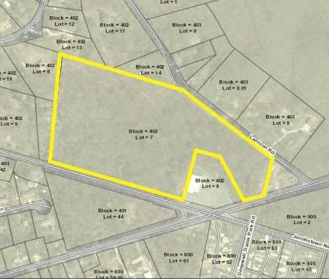
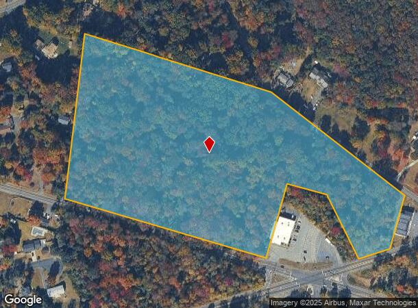
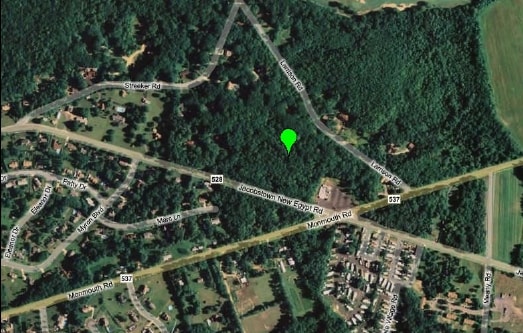
Jacobstown-New Egypt Rd
26-00402-0000-00007
Burlington
Vacantlandnec
New Jersey
X
7
34005C0180F
18.21 AC
2024
South Burlington County
2025
Philadelphia
704500
Philadelphia-Camden-Wilmington, PA-NJ-DE-MD
DEMOGRAPHICS near Jacobstown-New Egypt Rd
1 Mile
3 Mile
5 Mile
2024 Total Population
1,455
11,828
19,621
2029 Population
1,483
12,031
19,950
Pop Growth 2024-2029
+ 1.92%
+ 1.72%
+ 1.68%
Average Age
43
36
38
2024 Total Households
581
4,041
6,708
HH Growth 2024-2029
+ 1.89%
+ 1.78%
+ 1.52%
Median Household Inc
$86,388
$83,878
$91,510
Avg Household Size
2.50
2.70
2.70
2024 Avg HH Vehicles
2.00
2.00
2.00
Median Home Value
$342,261
$347,771
$390,048
Median Year Built
1978
1987
1987
Nearby Places
Map Layers
Map Styles
 Street
 Aerial
- Restaurants
- Banks
- Shops
- Fitness
- Groceries
PUBLIC TRANSPORTATION
AIRPORT
Trenton Mercer
DRIVE
WALK
Distance
Trenton Mercer
38 min
22.7 mi
Freight Ports
Port of Philadelphia
DRIVE
WALK
Distance
Port of Philadelphia
52 min
35.7 mi
SALE & LEASE HISTORY
LISTING DATE
SALE/LEASE

Jan 29, 2020
For Sale
Dec 11, 2018
For Sale
Nearby Properties
Address
Land Use
TOTAL SIZE
Lot Size
Zoning
Address
Land Use
TOTAL SIZE
Lot Size
Zoning
Address
Land Use
TOTAL SIZE
Lot Size
Zoning
Address
Land Use
TOTAL SIZE
Lot Size
Zoning
131.54 AC
L1
Address
Land Use
TOTAL SIZE
Lot Size
Zoning
38.06 AC
Address
Land Use
TOTAL SIZE
Lot Size
Zoning
16.15 AC
Address
Land Use
TOTAL SIZE
Lot Size
Zoning
680 SF
10 AC
C4
Address
Land Use
TOTAL SIZE
Lot Size
Zoning
14,136 SF
42.79 AC
AR
Address
Land Use
TOTAL SIZE
Lot Size
Zoning
1,965 SF
225 AC
Address
Land Use
TOTAL SIZE
Lot Size
Zoning
15.01 AC
L1
Address
Land Use
TOTAL SIZE
Lot Size
Zoning
Address
Land Use
TOTAL SIZE
Lot Size
Zoning
Address
Land Use
TOTAL SIZE
Lot Size
Zoning
Address
Land Use
TOTAL SIZE
Lot Size
Zoning
Address
Land Use
TOTAL SIZE
Lot Size
Zoning
118.32 AC
Address
Land Use
TOTAL SIZE
Lot Size
Zoning
5.48 AC
Address
Land Use
TOTAL SIZE
Lot Size
Zoning
1,211 SF
22.95 AC
Address
Land Use
TOTAL SIZE
Lot Size
Zoning
24.11 AC
L1
Address
Land Use
TOTAL SIZE
Lot Size
Zoning
Address
Land Use
TOTAL SIZE
Lot Size
Zoning
1,650 SF
7.04 AC
LI
Address
Land Use
TOTAL SIZE
Lot Size
Zoning
10.02 AC
Address
Land Use
TOTAL SIZE
Lot Size
Zoning
38.58 AC
Address
Land Use
TOTAL SIZE
Lot Size
Zoning
Address
Land Use
TOTAL SIZE
Lot Size
Zoning
Address
Land Use
TOTAL SIZE
Lot Size
Zoning
20,703 SF
0.43 AC
VB
Address
Land Use
TOTAL SIZE
Lot Size
Zoning
10,075 SF
5.72 AC
GC
Address
Land Use
TOTAL SIZE
Lot Size
Zoning
Address
Land Use
TOTAL SIZE
Lot Size
Zoning
Address
Land Use
TOTAL SIZE
Lot Size
Zoning
7,764 SF
1 AC
AR
Address
Land Use
TOTAL SIZE
Lot Size
Zoning
89.96 AC
AR
Address
Land Use
TOTAL SIZE
Lot Size
Zoning
2,862 SF
63.02 AC
AR
The World's #1 Commercial Real Estate Marketplace
Connect with us
© 2025 CoStar Group
The information above has been obtained from sources believed reliable. While we do not doubt its accuracy we have not verified it and make no guarantee, warranty or representation about it. It is your responsibility to independently confirm its accuracy and completeness. Any projections, opinions, assumptions, or estimates used are for example only and do not represent the current or future performance of the property. The value of this transaction to you depends on tax and other factors which should be evaluated by your tax, financial, and legal advisors. You and your advisors should conduct a careful, independent investigation of the property to determine to your satisfaction the suitability of the property for your needs.