Property Record
James Monroe Hwy, Culpeper, VA 22701
NEARBY LISTINGS FOR SALE OR LEASE
Property Detail
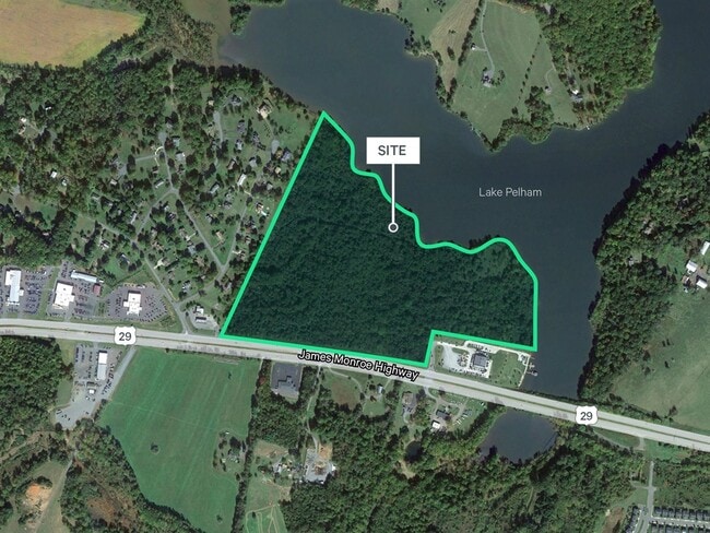
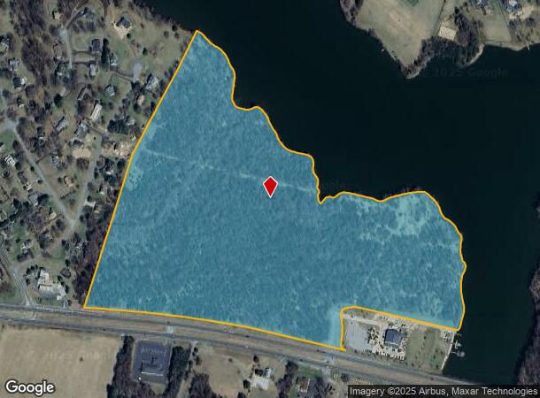
James Monroe Hwy
40-47
HUNGRY RUN LG PLAT CAB 1/59 30.32 AC ZONED C2
Commercialacreage
Culpeper
AE
Virginia
51047C0210D
68.07 AC
2024
Suburban Virginia Area
2025
Other Market Areas
930204
Washington-Arlington-Alexandria, DC-VA-MD-WV
DEMOGRAPHICS near James Monroe Hwy
1 Mile
3 Mile
5 Mile
2024 Total Population
1,680
22,650
34,670
2029 Population
1,843
24,846
37,931
Pop Growth 2024-2029
+ 9.70%
+ 9.70%
+ 9.41%
Average Age
40
39
39
2024 Total Households
616
7,781
11,966
HH Growth 2024-2029
+ 9.74%
+ 9.90%
+ 9.59%
Median Household Inc
$88,312
$86,635
$86,539
Avg Household Size
2.70
2.80
2.80
2024 Avg HH Vehicles
2.00
2.00
2.00
Median Home Value
$327,734
$336,249
$336,127
Median Year Built
1997
1994
1993
Nearby Places
- Restaurants
- Banks
- Shops
- Fitness
- Groceries
PUBLIC TRANSPORTATION
COMMUTER RAIL
Culpeper Amtrak Station (Cardinal - Amtrak, Crescent - Amtrak, Northeast Regional - Amtrak)
DRIVE
WALK
Distance
Culpeper Amtrak Station (Cardinal - Amtrak, Crescent - Amtrak, Northeast Regional - Amtrak)
7 min
3.4 mi
Freight Ports
Virginia Port Authority - Richmond
DRIVE
WALK
Distance
Virginia Port Authority - Richmond
122 min
95.7 mi
Nearby Properties
Address
Land Use
TOTAL SIZE
Lot Size
Zoning
Address
Land Use
TOTAL SIZE
Lot Size
Zoning
147,265 SF
29.61 AC
M1
Address
Land Use
TOTAL SIZE
Lot Size
Zoning
166,825 SF
11.09 AC
R2
Address
Land Use
TOTAL SIZE
Lot Size
Zoning
135,497 SF
108.90 AC
R2
Address
Land Use
TOTAL SIZE
Lot Size
Zoning
58.15 AC
M2
Address
Land Use
TOTAL SIZE
Lot Size
Zoning
58.15 AC
M2
Address
Land Use
TOTAL SIZE
Lot Size
Zoning
19,602 SF
10.32 AC
M1
Address
Land Use
TOTAL SIZE
Lot Size
Zoning
35.27 AC
M2
Address
Land Use
TOTAL SIZE
Lot Size
Zoning
34.64 AC
M2
Address
Land Use
TOTAL SIZE
Lot Size
Zoning
66,558 SF
29.23 AC
R2
Address
Land Use
TOTAL SIZE
Lot Size
Zoning
6,294 SF
33.37 AC
M2
Address
Land Use
TOTAL SIZE
Lot Size
Zoning
230,016 SF
89.13 AC
LI
Address
Land Use
TOTAL SIZE
Lot Size
Zoning
82,000 SF
13.24 AC
R1
Address
Land Use
TOTAL SIZE
Lot Size
Zoning
55,920 SF
3.68 AC
C3
Address
Land Use
TOTAL SIZE
Lot Size
Zoning
1,080 SF
6.92 AC
R3
Address
Land Use
TOTAL SIZE
Lot Size
Zoning
35,061 SF
3.51 AC
C1
Address
Land Use
TOTAL SIZE
Lot Size
Zoning
13,536 SF
9.84 AC
R4
Address
Land Use
TOTAL SIZE
Lot Size
Zoning
59,210 SF
4.40 AC
R1R3
Address
Land Use
TOTAL SIZE
Lot Size
Zoning
282,110 SF
30.44 AC
M2
Address
Land Use
TOTAL SIZE
Lot Size
Zoning
53,978 SF
10 AC
R2
Address
Land Use
TOTAL SIZE
Lot Size
Zoning
126,869 SF
25.68 AC
M2
Address
Land Use
TOTAL SIZE
Lot Size
Zoning
27,661 SF
1.21 AC
C2
Address
Land Use
TOTAL SIZE
Lot Size
Zoning
1,920 SF
119.78 AC
R3
Address
Land Use
TOTAL SIZE
Lot Size
Zoning
9,180 SF
6.93 AC
M2
Address
Land Use
TOTAL SIZE
Lot Size
Zoning
48,289 SF
15.14 AC
C3M2
Address
Land Use
TOTAL SIZE
Lot Size
Zoning
998 SF
11.03 AC
C3
Address
Land Use
TOTAL SIZE
Lot Size
Zoning
2,693 SF
4.98 AC
R4
Address
Land Use
TOTAL SIZE
Lot Size
Zoning
12.25 AC
M2
Address
Land Use
TOTAL SIZE
Lot Size
Zoning
173,752 SF
54.63 AC
M2
Address
Land Use
TOTAL SIZE
Lot Size
Zoning
20,896 SF
5.24 AC
R2
Address
Land Use
TOTAL SIZE
Lot Size
Zoning
11.54 AC
LI
The World's #1 Commercial Real Estate Marketplace
Connect with us
© 2025 CoStar Group
The information above has been obtained from sources believed reliable. While we do not doubt its accuracy we have not verified it and make no guarantee, warranty or representation about it. It is your responsibility to independently confirm its accuracy and completeness. Any projections, opinions, assumptions, or estimates used are for example only and do not represent the current or future performance of the property. The value of this transaction to you depends on tax and other factors which should be evaluated by your tax, financial, and legal advisors. You and your advisors should conduct a careful, independent investigation of the property to determine to your satisfaction the suitability of the property for your needs.