Property Record
4501 Jaybird Rd, Bessemer, AL 35020
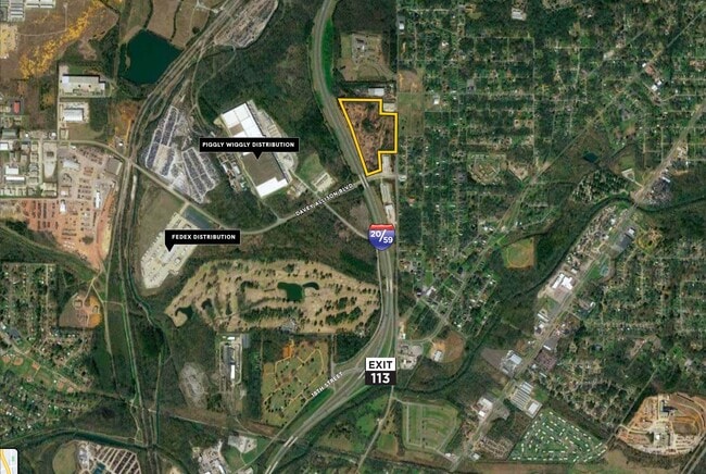
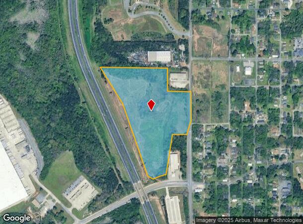
This Property Is For Sale
NEARBY LISTINGS FOR SALE OR LEASE
-
-
No Photo
-
-
-
-
View all Bessemer listings for sale on LoopNet.com
Property Detail
4501 Jaybird Rd
30-00-28-4-001-004.000
POB 899 FT S OF INTERSEC OF W LINE JAY BIRD RD & N LINE SE 1/4 SEC 28 T18S R4W TH S 410 FT W 10 FT SW 160 FT W 188.9 FT SW 540 FT TH SW 200 FT NW 80 FT TH NWLY ALG R/W OF I-59 1560 FT TH E 895 FT S 300 FT E 290 FT TO POB
Vacantlandnec
Jefferson
X
Alabama
01073C0529G
21.50 AC
2023
Bessemer
2024
Birmingham
0136015034
Birmingham-Hoover, AL
DEMOGRAPHICS near 4501 Jaybird Rd
1 Mile
3 Mile
5 Mile
2024 Total Population
3,001
39,724
89,792
2029 Population
3,076
39,385
88,999
Pop Growth 2024-2029
+ 2.50%
(0.85%)
(0.88%)
Average Age
42
41
40
2024 Total Households
1,213
15,696
35,993
HH Growth 2024-2029
+ 2.56%
(0.95%)
(1.00%)
Median Household Inc
$32,403
$44,484
$45,568
Avg Household Size
2.30
2.40
2.40
2024 Avg HH Vehicles
1.00
2.00
2.00
Median Home Value
$61,200
$120,683
$118,887
Median Year Built
1961
1964
1965
Nearby Places
- Restaurants
- Banks
- Shops
- Fitness
- Groceries
PUBLIC TRANSPORTATION
AIRPORT
Birmingham-Shuttlesworth International
DRIVE
WALK
Distance
Birmingham-Shuttlesworth International
20 min
16.8 mi
Freight Ports
Port of Mobile
DRIVE
WALK
Distance
Port of Mobile
285 min
243.2 mi
Nearby Properties
Address
Land Use
TOTAL SIZE
Lot Size
Zoning
Address
Land Use
TOTAL SIZE
Lot Size
Zoning
1,244,986 SF
I2
Address
Land Use
TOTAL SIZE
Lot Size
Zoning
2,573,547 SF
112 AC
I2
Address
Land Use
TOTAL SIZE
Lot Size
Zoning
460,483 SF
20 AC
I3
Address
Land Use
TOTAL SIZE
Lot Size
Zoning
116,442 SF
2.67 AC
B6
Address
Land Use
TOTAL SIZE
Lot Size
Zoning
195,495 SF
28.97 AC
B3
Address
Land Use
TOTAL SIZE
Lot Size
Zoning
553,137 SF
87 AC
I2
Address
Land Use
TOTAL SIZE
Lot Size
Zoning
191,664 SF
14.73 AC
R4
Address
Land Use
TOTAL SIZE
Lot Size
Zoning
136,115 SF
14.90 AC
C3
Address
Land Use
TOTAL SIZE
Lot Size
Zoning
145,300 SF
25 AC
R3
Address
Land Use
TOTAL SIZE
Lot Size
Zoning
288,000 SF
39.40 AC
I2-I
Address
Land Use
TOTAL SIZE
Lot Size
Zoning
219,210 SF
19.40 AC
M2
Address
Land Use
TOTAL SIZE
Lot Size
Zoning
230,088 SF
I3
Address
Land Use
TOTAL SIZE
Lot Size
Zoning
66,928 SF
5.70 AC
B2-R
Address
Land Use
TOTAL SIZE
Lot Size
Zoning
77,902 SF
44 AC
I3
Address
Land Use
TOTAL SIZE
Lot Size
Zoning
1,090,237 SF
28.10 AC
I4
Address
Land Use
TOTAL SIZE
Lot Size
Zoning
66,900 SF
3.78 AC
I4
Address
Land Use
TOTAL SIZE
Lot Size
Zoning
58,822 SF
7.80 AC
B3
Address
Land Use
TOTAL SIZE
Lot Size
Zoning
1,200 SF
13.40 AC
R3
Address
Land Use
TOTAL SIZE
Lot Size
Zoning
69,344 SF
2.30 AC
B-1
Address
Land Use
TOTAL SIZE
Lot Size
Zoning
26,234 SF
3.30 AC
B2
Address
Land Use
TOTAL SIZE
Lot Size
Zoning
366,421 SF
21 AC
I3
Address
Land Use
TOTAL SIZE
Lot Size
Zoning
1,437,077 SF
I2
Address
Land Use
TOTAL SIZE
Lot Size
Zoning
80,043 SF
10.89 AC
B3-C
Address
Land Use
TOTAL SIZE
Lot Size
Zoning
163,056 SF
I-3
Address
Land Use
TOTAL SIZE
Lot Size
Zoning
96,543 SF
8.80 AC
B2
Address
Land Use
TOTAL SIZE
Lot Size
Zoning
49,022 SF
5.50 AC
R2
Address
Land Use
TOTAL SIZE
Lot Size
Zoning
43,674 SF
0.44 AC
C3
Address
Land Use
TOTAL SIZE
Lot Size
Zoning
80,220 SF
6.68 AC
M2
Address
Land Use
TOTAL SIZE
Lot Size
Zoning
40,098 SF
0.48 AC
C1
Address
Land Use
TOTAL SIZE
Lot Size
Zoning
52,810 SF
3.44 AC
B-3
The World's #1 Commercial Real Estate Marketplace
Connect with us
© 2025 CoStar Group
The information above has been obtained from sources believed reliable. While we do not doubt its accuracy we have not verified it and make no guarantee, warranty or representation about it. It is your responsibility to independently confirm its accuracy and completeness. Any projections, opinions, assumptions, or estimates used are for example only and do not represent the current or future performance of the property. The value of this transaction to you depends on tax and other factors which should be evaluated by your tax, financial, and legal advisors. You and your advisors should conduct a careful, independent investigation of the property to determine to your satisfaction the suitability of the property for your needs.