Property Record
Jefferson Rd, Athens, GA 30607
NEARBY LISTINGS FOR SALE OR LEASE
Property Detail
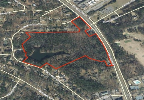
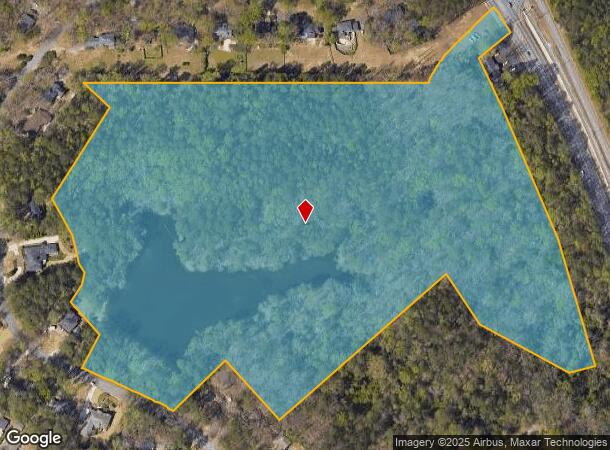
Jefferson Rd
Athens-Clarke County, GA
Res-St-043->00-03
111-031
DEEDED ACS: 31.845
Privatepreserveopenspacevacantlandforestlandconservation
Clarke
X
Georgia
13059C0014E
31.84 AC
2025
Westside Athens
2025
Other Market Areas
010602
DEMOGRAPHICS near Jefferson Rd
1 Mile
3 Mile
5 Mile
2024 Total Population
2,941
43,462
94,642
2029 Population
2,973
43,521
95,551
Pop Growth 2024-2029
+ 1.09%
+ 0.14%
+ 0.96%
Average Age
40
36
34
2024 Total Households
1,115
18,357
36,936
HH Growth 2024-2029
+ 1.26%
+ 0.13%
+ 0.92%
Median Household Inc
$59,999
$47,616
$48,856
Avg Household Size
2.50
2.20
2.20
2024 Avg HH Vehicles
2.00
2.00
2.00
Median Home Value
$225,000
$263,986
$271,228
Median Year Built
1977
1981
1985
Nearby Places
Map Layers
Map Styles
 Street
 Aerial
- Restaurants
- Banks
- Shops
- Fitness
- Groceries
SALE & LEASE HISTORY
LISTING DATE
SALE/LEASE

Sep 24, 2016
For Sale
Nearby Properties
Address
Land Use
TOTAL SIZE
Lot Size
Zoning
Address
Land Use
TOTAL SIZE
Lot Size
Zoning
11.36 AC
G
Address
Land Use
TOTAL SIZE
Lot Size
Zoning
163,904 SF
3.75 AC
C-D
Address
Land Use
TOTAL SIZE
Lot Size
Zoning
85,608 SF
63.75 AC
RM-2
Address
Land Use
TOTAL SIZE
Lot Size
Zoning
87,066 SF
36.66 AC
RM-2
Address
Land Use
TOTAL SIZE
Lot Size
Zoning
213,612 SF
3.07 AC
C-D
Address
Land Use
TOTAL SIZE
Lot Size
Zoning
184,293 SF
1.84 AC
C-D
Address
Land Use
TOTAL SIZE
Lot Size
Zoning
56.15 AC
G
Address
Land Use
TOTAL SIZE
Lot Size
Zoning
20 AC
G
Address
Land Use
TOTAL SIZE
Lot Size
Zoning
97,317 SF
24.31 AC
C-G
Address
Land Use
TOTAL SIZE
Lot Size
Zoning
5,501 SF
1.47 AC
C-D
Address
Land Use
TOTAL SIZE
Lot Size
Zoning
4,907 SF
28.35 AC
RM-2
Address
Land Use
TOTAL SIZE
Lot Size
Zoning
18.47 AC
C-G
Address
Land Use
TOTAL SIZE
Lot Size
Zoning
112,071 SF
5.27 AC
E-O
Address
Land Use
TOTAL SIZE
Lot Size
Zoning
136,404 SF
1.72 AC
G
Address
Land Use
TOTAL SIZE
Lot Size
Zoning
66,200 SF
13.35 AC
G
Address
Land Use
TOTAL SIZE
Lot Size
Zoning
36.74 AC
G
Address
Land Use
TOTAL SIZE
Lot Size
Zoning
8,357 SF
22.38 AC
RM-2
Address
Land Use
TOTAL SIZE
Lot Size
Zoning
118,239 SF
2.80 AC
C-D(ND)
Address
Land Use
TOTAL SIZE
Lot Size
Zoning
137,661 SF
1.96 AC
C-D
Address
Land Use
TOTAL SIZE
Lot Size
Zoning
125,888 SF
1.11 AC
C-D
Address
Land Use
TOTAL SIZE
Lot Size
Zoning
8,423 SF
1.07 AC
C-D
Address
Land Use
TOTAL SIZE
Lot Size
Zoning
77,919 SF
8 AC
E-I
Address
Land Use
TOTAL SIZE
Lot Size
Zoning
64,466 SF
1.08 AC
C-D
Address
Land Use
TOTAL SIZE
Lot Size
Zoning
101,920 SF
18.01 AC
RM-2
Address
Land Use
TOTAL SIZE
Lot Size
Zoning
108,922 SF
1.34 AC
C-D
Address
Land Use
TOTAL SIZE
Lot Size
Zoning
4,373 SF
25.41 AC
RM-2
Address
Land Use
TOTAL SIZE
Lot Size
Zoning
83,755 SF
1.70 AC
C-D
Address
Land Use
TOTAL SIZE
Lot Size
Zoning
1,672 SF
23.70 AC
RM-2
Address
Land Use
TOTAL SIZE
Lot Size
Zoning
38,928 SF
18.56 AC
RM-2
Address
Land Use
TOTAL SIZE
Lot Size
Zoning
65,817 SF
4.45 AC
G
The World's #1 Commercial Real Estate Marketplace
Connect with us
© 2025 CoStar Group
The information above has been obtained from sources believed reliable. While we do not doubt its accuracy we have not verified it and make no guarantee, warranty or representation about it. It is your responsibility to independently confirm its accuracy and completeness. Any projections, opinions, assumptions, or estimates used are for example only and do not represent the current or future performance of the property. The value of this transaction to you depends on tax and other factors which should be evaluated by your tax, financial, and legal advisors. You and your advisors should conduct a careful, independent investigation of the property to determine to your satisfaction the suitability of the property for your needs.