Property Record
200 Joe Mann Blvd, Midland, MI 48642

NEARBY LISTINGS FOR SALE OR LEASE
-
-
View all Midland listings for sale on LoopNet.com
Property Detail
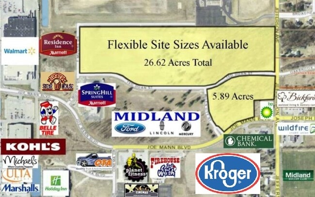
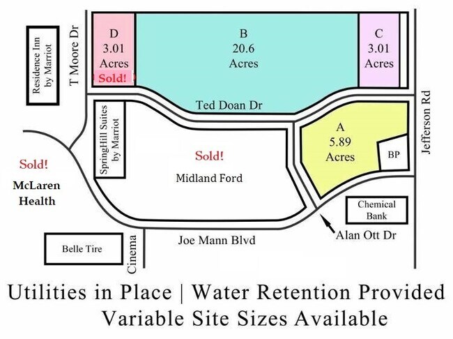
200 Joe Mann Blvd
11-33-30-840
N 1/2 OF SE 1/4 OF SEC 33, LYG N OF JOE MANN BLVD, S OF TED DOAN DR, E OF ALLEN OTT DR AND W OF JEFFERSON AVE, EXC BEG AT A
Commercialacreage
Midland
X
Michigan
26111C0186E
7.70 AC
2024
Midland/Flint
2025
Other Market Areas
290902
Midland, MI
DEMOGRAPHICS near 200 Joe Mann Blvd
1 mile
3 mile
5 mile
2024 Total Population
2,062
29,213
48,754
2029 Population
2,050
29,072
48,840
Pop Growth 2024-2029
(0.58%)
(0.48%)
+ 0.18%
Average Age
42
42
42
2024 Total Households
758
11,816
20,287
HH Growth 2024-2029
(0.66%)
(0.52%)
+ 0.22%
Median Household Inc
$136,730
$87,793
$70,947
Avg Household Size
2.70
2.40
2.30
2024 Avg HH Vehicles
2.00
2.00
2.00
Median Home Value
$244,767
$208,636
$189,929
Median Year Built
1977
1974
1973
Nearby Places
Map Layers
Map Styles
 Street
 Aerial
Transit
 Traffic
 Biking
Places
Listings with unknown addresses are not visible on the map
- Restaurants
- Banks
- Shops
- Fitness
- Groceries
PUBLIC TRANSPORTATION
AIRPORT
MBS International
Drive
Walk
Distance
MBS International
24 min
16.0 mi
Freight Ports
Port of Toledo
Drive
Walk
Distance
Port of Toledo
198 min
174.5 mi
SALE & LEASE HISTORY
LISTING DATE
SALE/LEASE

Feb 24, 2021
For Sale
Nearby Properties
Address
Land Use
TOTAL SIZE
Lot Size
Zoning
Address
Land Use
TOTAL SIZE
Lot Size
Zoning
42,647 SF
12.42 AC
RA-4
Address
Land Use
TOTAL SIZE
Lot Size
Zoning
83,416 SF
1.21 AC
COM
Address
Land Use
TOTAL SIZE
Lot Size
Zoning
116,057 SF
120 AC
RA-1
Address
Land Use
TOTAL SIZE
Lot Size
Zoning
13.43 AC
RB
Address
Land Use
TOTAL SIZE
Lot Size
Zoning
252,442 SF
70.03 AC
AG
Address
Land Use
TOTAL SIZE
Lot Size
Zoning
357,933 SF
33.35 AC
RC
Address
Land Use
TOTAL SIZE
Lot Size
Zoning
189,978 SF
18.01 AC
RB
Address
Land Use
TOTAL SIZE
Lot Size
Zoning
116,274 SF
4.59 AC
RC
Address
Land Use
TOTAL SIZE
Lot Size
Zoning
115,878 SF
7.53 AC
RB
Address
Land Use
TOTAL SIZE
Lot Size
Zoning
223,029 SF
18.50 AC
OS
Address
Land Use
TOTAL SIZE
Lot Size
Zoning
201,174 SF
27.52 AC
RC
Address
Land Use
TOTAL SIZE
Lot Size
Zoning
207,859 SF
21.12 AC
RC
Address
Land Use
TOTAL SIZE
Lot Size
Zoning
55,872 SF
3.85 AC
RC
Address
Land Use
TOTAL SIZE
Lot Size
Zoning
61,516 SF
5.31 AC
RC
Address
Land Use
TOTAL SIZE
Lot Size
Zoning
143.72 AC
LCMR
Address
Land Use
TOTAL SIZE
Lot Size
Zoning
53,950 SF
16.40 AC
RC
Address
Land Use
TOTAL SIZE
Lot Size
Zoning
55,926 SF
1.72 AC
CC
Address
Land Use
TOTAL SIZE
Lot Size
Zoning
64,769 SF
3.17 AC
RC
Address
Land Use
TOTAL SIZE
Lot Size
Zoning
81,009 SF
3.33 AC
RC
Address
Land Use
TOTAL SIZE
Lot Size
Zoning
133,004 SF
9.72 AC
RB
Address
Land Use
TOTAL SIZE
Lot Size
Zoning
81,373 SF
8.93 AC
RC
Address
Land Use
TOTAL SIZE
Lot Size
Zoning
74,532 SF
6.55 AC
RC
Address
Land Use
TOTAL SIZE
Lot Size
Zoning
40,763 SF
11 AC
RB
Address
Land Use
TOTAL SIZE
Lot Size
Zoning
88,104 SF
9 AC
RC
Address
Land Use
TOTAL SIZE
Lot Size
Zoning
6,062 SF
23.22 AC
RB
Address
Land Use
TOTAL SIZE
Lot Size
Zoning
62,440 SF
7.34 AC
RC
Address
Land Use
TOTAL SIZE
Lot Size
Zoning
67,173 SF
3.59 AC
RB
Address
Land Use
TOTAL SIZE
Lot Size
Zoning
104,458 SF
9.44 AC
RC
Address
Land Use
TOTAL SIZE
Lot Size
Zoning
38,127 SF
9.72 AC
IA
Address
Land Use
TOTAL SIZE
Lot Size
Zoning
35,826 SF
4.67 AC
RA-1
The World's #1 Commercial Real Estate Marketplace
Connect with us
© 2026 CoStar Group
The information above has been obtained from sources believed reliable. While we do not doubt its accuracy we have not verified it and make no guarantee, warranty or representation about it. It is your responsibility to independently confirm its accuracy and completeness. Any projections, opinions, assumptions, or estimates used are for example only and do not represent the current or future performance of the property. The value of this transaction to you depends on tax and other factors which should be evaluated by your tax, financial, and legal advisors. You and your advisors should conduct a careful, independent investigation of the property to determine to your satisfaction the suitability of the property for your needs.