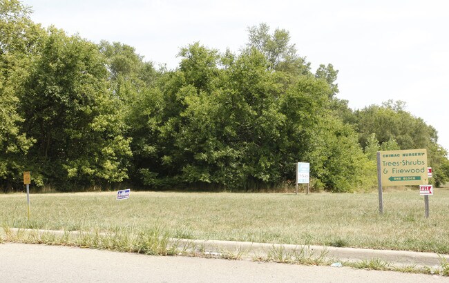
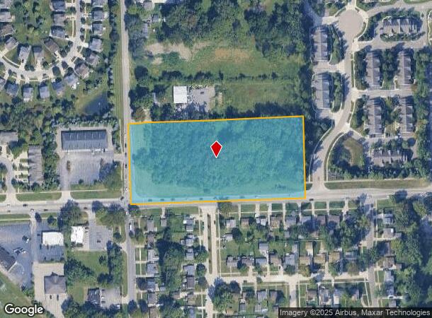
Property Record
N John Hix Rd, Westland, MI 48185
NEARBY LISTINGS FOR SALE OR LEASE
Property Detail
N John Hix Rd
Detroit-Warren-Dearborn, MI
Condominium
56-051-99-0060-000
18X THE S 1/2 OF THE W 1/2 OF THE S 1/2 OF THE S E 1/4 OF THE S W 1/4 OF SEC 18 5.42 ACRES
Residentialacreage
Wayne
X
Michigan
26163C0216E
0060
2024
5 AC
2025
Southern I-275 Corridor
567800
Detroit
DEMOGRAPHICS near N John Hix Rd
1 Mile
3 Mile
5 Mile
2024 Total Population
10,041
90,672
217,965
2029 Population
9,619
86,782
209,197
Pop Growth 2024-2029
(4.20%)
(4.29%)
(4.02%)
Average Age
41
41
41
2024 Total Households
3,980
38,394
89,775
HH Growth 2024-2029
(4.17%)
(4.31%)
(4.04%)
Median Household Inc
$72,512
$66,508
$72,590
Avg Household Size
2.50
2.30
2.40
2024 Avg HH Vehicles
2.00
2.00
2.00
Median Home Value
$197,058
$199,648
$208,692
Median Year Built
1976
1976
1972
Nearby Places
Map Layers
Map Styles
 Street
 Aerial
- Restaurants
- Banks
- Shops
- Fitness
- Groceries
PUBLIC TRANSPORTATION
AIRPORT
Detroit Metro Wayne County
DRIVE
WALK
Distance
Detroit Metro Wayne County
19 min
14.0 mi
Windsor International
DRIVE
WALK
Distance
Windsor International
57 min
36.6 mi
Freight Ports
Port of Toledo
DRIVE
WALK
Distance
Port of Toledo
69 min
55.7 mi
SALE & LEASE HISTORY
LISTING DATE
SALE/LEASE

Sep 24, 2016
For Sale
Jun 08, 2018
For Sale
Nearby Properties
Address
Land Use
TOTAL SIZE
Lot Size
Zoning
Address
Land Use
TOTAL SIZE
Lot Size
Zoning
741,173 SF
63.81 AC
Address
Land Use
TOTAL SIZE
Lot Size
Zoning
400,857 SF
27.44 AC
RP
Address
Land Use
TOTAL SIZE
Lot Size
Zoning
39.50 AC
MR
Address
Land Use
TOTAL SIZE
Lot Size
Zoning
176,796 SF
17.08 AC
C-2
Address
Land Use
TOTAL SIZE
Lot Size
Zoning
167,491 SF
18.59 AC
Address
Land Use
TOTAL SIZE
Lot Size
Zoning
408,122 SF
23.31 AC
MR
Address
Land Use
TOTAL SIZE
Lot Size
Zoning
21.71 AC
MR
Address
Land Use
TOTAL SIZE
Lot Size
Zoning
311,556 SF
23.17 AC
C-3
Address
Land Use
TOTAL SIZE
Lot Size
Zoning
352,514 SF
26.40 AC
Address
Land Use
TOTAL SIZE
Lot Size
Zoning
1,789,755 SF
138.32 AC
IND-2 HVY
Address
Land Use
TOTAL SIZE
Lot Size
Zoning
20.91 AC
Address
Land Use
TOTAL SIZE
Lot Size
Zoning
395,148 SF
9.67 AC
Address
Land Use
TOTAL SIZE
Lot Size
Zoning
169,489 SF
14.51 AC
R-6
Address
Land Use
TOTAL SIZE
Lot Size
Zoning
Address
Land Use
TOTAL SIZE
Lot Size
Zoning
169,968 SF
12.46 AC
MR
Address
Land Use
TOTAL SIZE
Lot Size
Zoning
249,795 SF
21.17 AC
Address
Land Use
TOTAL SIZE
Lot Size
Zoning
286,188 SF
40.21 AC
Address
Land Use
TOTAL SIZE
Lot Size
Zoning
11.40 AC
MR
Address
Land Use
TOTAL SIZE
Lot Size
Zoning
16.03 AC
MR
Address
Land Use
TOTAL SIZE
Lot Size
Zoning
147,968 SF
16.68 AC
Address
Land Use
TOTAL SIZE
Lot Size
Zoning
66,670 SF
11.20 AC
C-3
Address
Land Use
TOTAL SIZE
Lot Size
Zoning
243,371 SF
16.04 AC
Address
Land Use
TOTAL SIZE
Lot Size
Zoning
269,649 SF
18.27 AC
LI-1
Address
Land Use
TOTAL SIZE
Lot Size
Zoning
199,952 SF
13.06 AC
Address
Land Use
TOTAL SIZE
Lot Size
Zoning
76,430 SF
13.61 AC
C-3
Address
Land Use
TOTAL SIZE
Lot Size
Zoning
1,200,000 SF
71.38 AC
IND-2 HVY
Address
Land Use
TOTAL SIZE
Lot Size
Zoning
1,059,457 SF
23.05 AC
IND-2 HVY
Address
Land Use
TOTAL SIZE
Lot Size
Zoning
73,056 SF
7.44 AC
C-3
Address
Land Use
TOTAL SIZE
Lot Size
Zoning
177,268 SF
17.11 AC
Address
Land Use
TOTAL SIZE
Lot Size
Zoning
5.80 AC
MR
The World's #1 Commercial Real Estate Marketplace
Connect with us
© 2025 CoStar Group
The information above has been obtained from sources believed reliable. While we do not doubt its accuracy we have not verified it and make no guarantee, warranty or representation about it. It is your responsibility to independently confirm its accuracy and completeness. Any projections, opinions, assumptions, or estimates used are for example only and do not represent the current or future performance of the property. The value of this transaction to you depends on tax and other factors which should be evaluated by your tax, financial, and legal advisors. You and your advisors should conduct a careful, independent investigation of the property to determine to your satisfaction the suitability of the property for your needs.