Property Record
John Sharp Pkwy, Bryan, TX 77807

Property Detail
John Sharp Pkwy
College Station-Bryan, TX
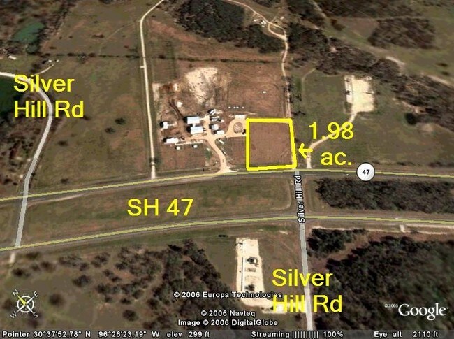
A003301, T F MCKINNEY (ICL), TRACT 15.12, 1.9781 ACRES
112004
BRAZOS
Commercialacreage
Texas
B and X Area of moderate flood hazard, usually the area between the limits of the 100-year and 500-year floods.
15.12
2024
1.98 AC
2025
Bryan & College Station
000205
Other Market Areas
NEARBY LISTINGS FOR SALE OR LEASE
DEMOGRAPHICS near John Sharp Pkwy
1 mile
3 mile
5 mile
2025 Total Population
272
5,626
42,307
2030 Population
296
6,102
45,354
Pop Growth 2025-2030
+ 8.82%
+ 8.46%
+ 7.20%
Average Age
36
34
34
2025 Total Households
103
2,248
15,553
HH Growth 2025-2030
+ 8.74%
+ 9.12%
+ 7.69%
Median Household Inc
$60,750
$86,403
$49,674
Avg Household Size
2.70
2.50
2.60
2025 Avg HH Vehicles
2.00
2.00
2.00
Median Home Value
$83,823
$263,671
$185,090
Median Year Built
1994
2010
1994
Nearby Places
Map Layers
Map Styles
 Street
 Aerial
Layers
 Traffic
 Biking
Places
Listings with unknown addresses are not visible on the map
- Restaurants
- Banks
- Shops
- Fitness
- Groceries
PUBLIC TRANSPORTATION
AIRPORT
Easterwood Field
Drive
Walk
Distance
Easterwood Field
18 min
9.6 mi
Freight Ports
Port of Houston
Drive
Walk
Distance
Port of Houston
130 min
106.3 mi
Nearby Properties
Address
Land Use
TOTAL SIZE
Lot Size
Zoning
Address
Land Use
TOTAL SIZE
Lot Size
Zoning
59.92 AC
Address
Land Use
TOTAL SIZE
Lot Size
Zoning
227,891 SF
350 AC
Address
Land Use
TOTAL SIZE
Lot Size
Zoning
170,072 SF
6.51 AC
Address
Land Use
TOTAL SIZE
Lot Size
Zoning
94,181 SF
15.18 AC
Address
Land Use
TOTAL SIZE
Lot Size
Zoning
15,526 SF
87.12 AC
Address
Land Use
TOTAL SIZE
Lot Size
Zoning
8,748 SF
107.30 AC
Address
Land Use
TOTAL SIZE
Lot Size
Zoning
196,836 SF
18.84 AC
Address
Land Use
TOTAL SIZE
Lot Size
Zoning
3,072 SF
50.38 AC
Address
Land Use
TOTAL SIZE
Lot Size
Zoning
15.50 AC
Address
Land Use
TOTAL SIZE
Lot Size
Zoning
64,130 SF
7.08 AC
Address
Land Use
TOTAL SIZE
Lot Size
Zoning
236,200 SF
12.96 AC
Address
Land Use
TOTAL SIZE
Lot Size
Zoning
79,200 SF
7.51 AC
Address
Land Use
TOTAL SIZE
Lot Size
Zoning
112,200 SF
19.74 AC
Address
Land Use
TOTAL SIZE
Lot Size
Zoning
59,620 SF
6.17 AC
Address
Land Use
TOTAL SIZE
Lot Size
Zoning
66,136 SF
13.16 AC
Address
Land Use
TOTAL SIZE
Lot Size
Zoning
1,991.39 AC
Address
Land Use
TOTAL SIZE
Lot Size
Zoning
79,200 SF
5.19 AC
Address
Land Use
TOTAL SIZE
Lot Size
Zoning
1,424 SF
17.25 AC
Address
Land Use
TOTAL SIZE
Lot Size
Zoning
55,815 SF
5 AC
Address
Land Use
TOTAL SIZE
Lot Size
Zoning
66,685 SF
13.48 AC
Address
Land Use
TOTAL SIZE
Lot Size
Zoning
10,235 SF
2.44 AC
Address
Land Use
TOTAL SIZE
Lot Size
Zoning
47,728 SF
1.09 AC
Address
Land Use
TOTAL SIZE
Lot Size
Zoning
64,754 SF
14.36 AC
Address
Land Use
TOTAL SIZE
Lot Size
Zoning
2,010 SF
9.92 AC
Address
Land Use
TOTAL SIZE
Lot Size
Zoning
28,160 SF
13.05 AC
Address
Land Use
TOTAL SIZE
Lot Size
Zoning
1.79 AC
Address
Land Use
TOTAL SIZE
Lot Size
Zoning
45,650 SF
8.09 AC
Address
Land Use
TOTAL SIZE
Lot Size
Zoning
27,720 SF
7.97 AC
Address
Land Use
TOTAL SIZE
Lot Size
Zoning
7,568 SF
7.77 AC
Address
Land Use
TOTAL SIZE
Lot Size
Zoning
174,840 SF
55.27 AC
The World's #1 Commercial Real Estate Marketplace
Connect with us
© 2026 CoStar Group
The information above has been obtained from sources believed reliable. While we do not doubt its accuracy we have not verified it and make no guarantee, warranty or representation about it. It is your responsibility to independently confirm its accuracy and completeness. Any projections, opinions, assumptions, or estimates used are for example only and do not represent the current or future performance of the property. The value of this transaction to you depends on tax and other factors which should be evaluated by your tax, financial, and legal advisors. You and your advisors should conduct a careful, independent investigation of the property to determine to your satisfaction the suitability of the property for your needs.