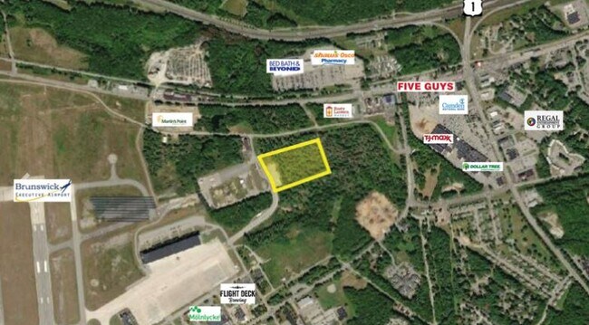
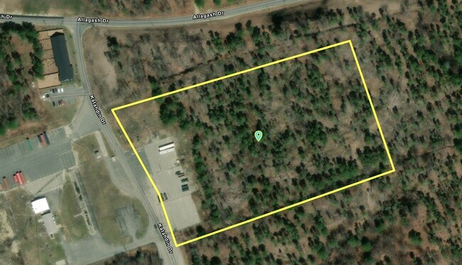
Property Record
Katahdin Dr, Brunswick, ME 04011
Current Lease Availabilities
Property Detail
Katahdin Dr
BRUN-000040-000000-000066
CUMBERLAND
Commercialnec
Maine
GM7
66
B and X Area of moderate flood hazard, usually the area between the limits of the 100-year and 500-year floods.
9.09 AC
2025
NE Cumberland County
2025
Portland/South Portland
011203
Portland-South Portland, ME
NEARBY LISTINGS FOR SALE OR LEASE
DEMOGRAPHICS near Katahdin Dr
1 mile
3 mile
5 mile
2025 Total Population
1,883
22,874
34,195
2030 Population
2,002
23,830
35,330
Pop Growth 2025-2030
+ 6.32%
+ 4.18%
+ 3.32%
Average Age
41
43
44
2025 Total Households
812
9,596
14,680
HH Growth 2025-2030
+ 6.77%
+ 4.27%
+ 3.35%
Median Household Inc
$48,554
$75,412
$79,302
Avg Household Size
2.10
2.10
2.10
2025 Avg HH Vehicles
1.00
2.00
2.00
Median Home Value
$329,710
$388,838
$383,046
Median Year Built
1997
1979
1981
Nearby Places
Map Layers
Map Styles
 Street
 Aerial
Layers
 Traffic
 Biking
Places
Listings with unknown addresses are not visible on the map
- Restaurants
- Banks
- Shops
- Fitness
- Groceries
PUBLIC TRANSPORTATION
COMMUTER RAIL
Brunswick Amtrak Station (Downeaster - Amtrak)
Drive
Walk
Distance
Brunswick Amtrak Station (Downeaster - Amtrak)
3 min
15 min
0.8 mi
AIRPORT
Portland International Jetport
Drive
Walk
Distance
Portland International Jetport
45 min
32.8 mi
Freight Ports
Portland, ME
Drive
Walk
Distance
Portland, ME
39 min
29.8 mi
Nearby Properties
Address
Land Use
TOTAL SIZE
Lot Size
Zoning
Address
Land Use
TOTAL SIZE
Lot Size
Zoning
21,788 SF
34.10 AC
GC1
Address
Land Use
TOTAL SIZE
Lot Size
Zoning
7,500 SF
712.04 AC
GA
Address
Land Use
TOTAL SIZE
Lot Size
Zoning
11.05 AC
GM7
Address
Land Use
TOTAL SIZE
Lot Size
Zoning
616.11 AC
NO
Address
Land Use
TOTAL SIZE
Lot Size
Zoning
252,409 SF
24.20 AC
GM4
Address
Land Use
TOTAL SIZE
Lot Size
Zoning
Address
Land Use
TOTAL SIZE
Lot Size
Zoning
17,228 SF
67.60 AC
GC5
Address
Land Use
TOTAL SIZE
Lot Size
Zoning
188,428 SF
54 AC
RP1
Address
Land Use
TOTAL SIZE
Lot Size
Zoning
111,099 SF
10.40 AC
GR8
Address
Land Use
TOTAL SIZE
Lot Size
Zoning
413,793 SF
4.94 AC
GM6
Address
Land Use
TOTAL SIZE
Lot Size
Zoning
5.77 AC
Address
Land Use
TOTAL SIZE
Lot Size
Zoning
158,044 SF
29.13 AC
GM4
Address
Land Use
TOTAL SIZE
Lot Size
Zoning
96,823 SF
13 AC
GR9
Address
Land Use
TOTAL SIZE
Lot Size
Zoning
199,222 SF
46.56 AC
NO
Address
Land Use
TOTAL SIZE
Lot Size
Zoning
203,981 SF
28.41 AC
GM4
Address
Land Use
TOTAL SIZE
Lot Size
Zoning
11,760 SF
5.68 AC
GM7
Address
Land Use
TOTAL SIZE
Lot Size
Zoning
5,238 SF
3.99 AC
GC1
Address
Land Use
TOTAL SIZE
Lot Size
Zoning
8,432 SF
8.80 AC
GM7
Address
Land Use
TOTAL SIZE
Lot Size
Zoning
193,840 SF
11.61 AC
GA
Address
Land Use
TOTAL SIZE
Lot Size
Zoning
51,162 SF
29.25 AC
GR9
Address
Land Use
TOTAL SIZE
Lot Size
Zoning
55 AC
GR4
Address
Land Use
TOTAL SIZE
Lot Size
Zoning
49,175 SF
6.70 AC
GM7
Address
Land Use
TOTAL SIZE
Lot Size
Zoning
206,533 SF
28 AC
GI
Address
Land Use
TOTAL SIZE
Lot Size
Zoning
137,400 SF
34.70 AC
GM4
Address
Land Use
TOTAL SIZE
Lot Size
Zoning
1,946 SF
2.46 AC
GM7
Address
Land Use
TOTAL SIZE
Lot Size
Zoning
8,340 SF
4.66 AC
GM7
Address
Land Use
TOTAL SIZE
Lot Size
Zoning
74,778 SF
23.51 AC
GM8
Address
Land Use
TOTAL SIZE
Lot Size
Zoning
3.52 AC
GM7
Address
Land Use
TOTAL SIZE
Lot Size
Zoning
124,514 SF
10.76 AC
NO
Address
Land Use
TOTAL SIZE
Lot Size
Zoning
16,090 SF
3.77 AC
GC2
The World's #1 Commercial Real Estate Marketplace
Connect with us
© 2026 CoStar Group
The information above has been obtained from sources believed reliable. While we do not doubt its accuracy we have not verified it and make no guarantee, warranty or representation about it. It is your responsibility to independently confirm its accuracy and completeness. Any projections, opinions, assumptions, or estimates used are for example only and do not represent the current or future performance of the property. The value of this transaction to you depends on tax and other factors which should be evaluated by your tax, financial, and legal advisors. You and your advisors should conduct a careful, independent investigation of the property to determine to your satisfaction the suitability of the property for your needs.