Property Record
Keel Hollow Rd, , AL

Property Detail
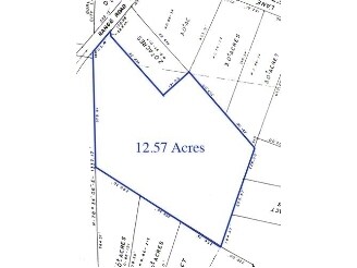
Keel Hollow Rd
Huntsville, AL
NE1/4 OF SE1/4 SEC 7 T5 R3E
21-03-07-0-000-020.000
MADISON
Wildliferefuge
Alabama
B and X Area of moderate flood hazard, usually the area between the limits of the 100-year and 500-year floods.
40 AC
2025
South Madison County
2025
Huntsville
010902
NEARBY LISTINGS FOR SALE OR LEASE
-
-
View all listings for sale on LoopNet.com
DEMOGRAPHICS near Keel Hollow Rd
1 mile
3 mile
5 mile
2025 Total Population
71
1,019
5,136
2030 Population
79
1,101
5,528
Pop Growth 2025-2030
+ 11.27%
+ 8.05%
+ 7.63%
Average Age
46
44
44
2025 Total Households
30
426
2,080
HH Growth 2025-2030
+ 10.00%
+ 7.98%
+ 7.79%
Median Household Inc
$58,571
$57,542
$69,374
Avg Household Size
2.40
2.40
2.40
2025 Avg HH Vehicles
2.00
2.00
2.00
Median Home Value
$433,333
$330,000
$341,810
Median Year Built
1995
1992
1994
Nearby Places
Map Layers
Map Styles
 Street
 Aerial
Transit
 Traffic
 Biking
Places
Listings with unknown addresses are not visible on the map
- Restaurants
- Banks
- Shops
- Fitness
- Groceries
Nearby Properties
Address
Land Use
TOTAL SIZE
Lot Size
Zoning
Address
Land Use
TOTAL SIZE
Lot Size
Zoning
4,907 SF
11.50 AC
Address
Land Use
TOTAL SIZE
Lot Size
Zoning
2,722 SF
1.10 AC
Address
Land Use
TOTAL SIZE
Lot Size
Zoning
3,552 SF
2.87 AC
Address
Land Use
TOTAL SIZE
Lot Size
Zoning
Address
Land Use
TOTAL SIZE
Lot Size
Zoning
4,000 SF
1.20 AC
Address
Land Use
TOTAL SIZE
Lot Size
Zoning
2,892 SF
72 AC
Address
Land Use
TOTAL SIZE
Lot Size
Zoning
1,800 SF
71 AC
Address
Land Use
TOTAL SIZE
Lot Size
Zoning
Address
Land Use
TOTAL SIZE
Lot Size
Zoning
1,926 SF
0.42 AC
Address
Land Use
TOTAL SIZE
Lot Size
Zoning
1,523 SF
14 AC
Address
Land Use
TOTAL SIZE
Lot Size
Zoning
506 AC
Address
Land Use
TOTAL SIZE
Lot Size
Zoning
Address
Land Use
TOTAL SIZE
Lot Size
Zoning
Address
Land Use
TOTAL SIZE
Lot Size
Zoning
1,956 SF
0.70 AC
Address
Land Use
TOTAL SIZE
Lot Size
Zoning
Address
Land Use
TOTAL SIZE
Lot Size
Zoning
3,441 SF
10.20 AC
Address
Land Use
TOTAL SIZE
Lot Size
Zoning
14 AC
Address
Land Use
TOTAL SIZE
Lot Size
Zoning
Address
Land Use
TOTAL SIZE
Lot Size
Zoning
Address
Land Use
TOTAL SIZE
Lot Size
Zoning
1,202 SF
0.30 AC
Address
Land Use
TOTAL SIZE
Lot Size
Zoning
Address
Land Use
TOTAL SIZE
Lot Size
Zoning
40 AC
Address
Land Use
TOTAL SIZE
Lot Size
Zoning
Address
Land Use
TOTAL SIZE
Lot Size
Zoning
Address
Land Use
TOTAL SIZE
Lot Size
Zoning
3,768 SF
0.22 AC
Address
Land Use
TOTAL SIZE
Lot Size
Zoning
23.85 AC
Address
Land Use
TOTAL SIZE
Lot Size
Zoning
72.80 AC
Address
Land Use
TOTAL SIZE
Lot Size
Zoning
18.08 AC
The World's #1 Commercial Real Estate Marketplace
Connect with us
© 2026 CoStar Group
The information above has been obtained from sources believed reliable. While we do not doubt its accuracy we have not verified it and make no guarantee, warranty or representation about it. It is your responsibility to independently confirm its accuracy and completeness. Any projections, opinions, assumptions, or estimates used are for example only and do not represent the current or future performance of the property. The value of this transaction to you depends on tax and other factors which should be evaluated by your tax, financial, and legal advisors. You and your advisors should conduct a careful, independent investigation of the property to determine to your satisfaction the suitability of the property for your needs.