Property Record
Ns # Ns, Leawood, KS 66224
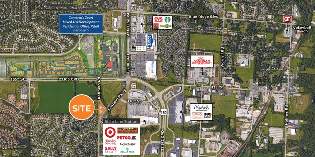
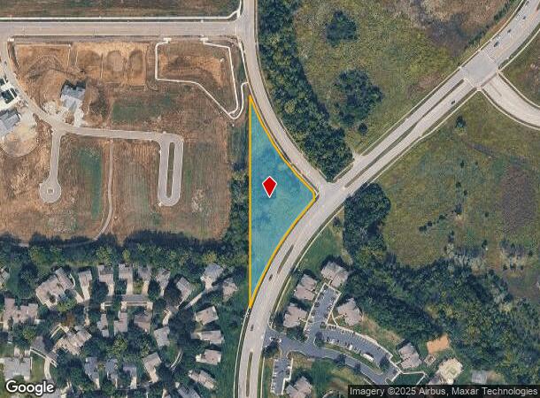
This Property Is For Sale
NEARBY LISTINGS FOR SALE OR LEASE
Property Detail
Ns # Ns
Kansas City, MO-KS
Hanover
HF251335-1015
35-13-25 BG 666.97 S NW CR N 1/2 FRAC SEC SELY ALG CUR LF285.21 SE 278.26 TO CTR/L KENNETH PKY SWLY 769.73 TO W/L N 1/2 FRAC & 1815.28 S NW CR N 1148.31 TO POB INCLUDING VAC KENNETH RD EX .116 AC & SUBJ TO RD 1.521 ACSM/L LWC 569 1G 1
Farms
Johnson
AE
Kansas
29095C0388G
d,e
2024
1.62 AC
2024
South Johnson County
053409
Kansas City
DEMOGRAPHICS near Ns # Ns
1 Mile
3 Mile
5 Mile
2024 Total Population
5,333
49,024
142,886
2029 Population
5,490
50,510
147,491
Pop Growth 2024-2029
+ 2.94%
+ 3.03%
+ 3.22%
Average Age
44
43
42
2024 Total Households
2,237
19,285
59,031
HH Growth 2024-2029
+ 2.91%
+ 3.02%
+ 3.31%
Median Household Inc
$119,561
$124,069
$98,427
Avg Household Size
2.40
2.50
2.30
2024 Avg HH Vehicles
2.00
2.00
2.00
Median Home Value
$522,694
$478,329
$388,914
Median Year Built
1996
1993
1990
Nearby Places
Map Layers
Map Styles
 Street
 Aerial
- Restaurants
- Banks
- Shops
- Fitness
- Groceries
PUBLIC TRANSPORTATION
AIRPORT
Kansas City International
DRIVE
WALK
Distance
Kansas City International
52 min
40.7 mi
Nearby Properties
Address
Land Use
TOTAL SIZE
Lot Size
Zoning
Address
Land Use
TOTAL SIZE
Lot Size
Zoning
364,818 SF
25.48 AC
R-1
Address
Land Use
TOTAL SIZE
Lot Size
Zoning
384,819 SF
67.59 AC
AG
Address
Land Use
TOTAL SIZE
Lot Size
Zoning
335,643 SF
25.13 AC
R-1
Address
Land Use
TOTAL SIZE
Lot Size
Zoning
184,524 SF
33.20 AC
AG
Address
Land Use
TOTAL SIZE
Lot Size
Zoning
325,588 SF
36.63 AC
SD-CR
Address
Land Use
TOTAL SIZE
Lot Size
Zoning
173,314 SF
25.83 AC
R-1
Address
Land Use
TOTAL SIZE
Lot Size
Zoning
79,917 SF
7.86 AC
SD-NCR
Address
Land Use
TOTAL SIZE
Lot Size
Zoning
122,491 SF
19.30 AC
R-1
Address
Land Use
TOTAL SIZE
Lot Size
Zoning
102,411 SF
17.02 AC
AG
Address
Land Use
TOTAL SIZE
Lot Size
Zoning
166,097 SF
37.29 AC
R-1
Address
Land Use
TOTAL SIZE
Lot Size
Zoning
105,110 SF
8.93 AC
AG
Address
Land Use
TOTAL SIZE
Lot Size
Zoning
76,942 SF
15.10 AC
R-1
Address
Land Use
TOTAL SIZE
Lot Size
Zoning
72,184 SF
9.53 AC
AG
Address
Land Use
TOTAL SIZE
Lot Size
Zoning
319,892 SF
Address
Land Use
TOTAL SIZE
Lot Size
Zoning
66,083 SF
14.91 AC
R-1
Address
Land Use
TOTAL SIZE
Lot Size
Zoning
9,508 SF
8.29 AC
RP-1
Address
Land Use
TOTAL SIZE
Lot Size
Zoning
159,274 SF
14.38 AC
SD-CR
Address
Land Use
TOTAL SIZE
Lot Size
Zoning
59,770 SF
8.88 AC
CP-2
Address
Land Use
TOTAL SIZE
Lot Size
Zoning
56,287 SF
7.88 AC
R-1
Address
Land Use
TOTAL SIZE
Lot Size
Zoning
28,633 SF
13.25 AC
R-1
Address
Land Use
TOTAL SIZE
Lot Size
Zoning
68,493 SF
9.92 AC
R-1
Address
Land Use
TOTAL SIZE
Lot Size
Zoning
40,181 SF
1.80 AC
MXD
Address
Land Use
TOTAL SIZE
Lot Size
Zoning
43,021 SF
7.47 AC
SD-O
Address
Land Use
TOTAL SIZE
Lot Size
Zoning
36,012 SF
18.10 AC
AG
Address
Land Use
TOTAL SIZE
Lot Size
Zoning
67,523 SF
11.95 AC
R-1
Address
Land Use
TOTAL SIZE
Lot Size
Zoning
26,022 SF
109.48 AC
IP-2J
Address
Land Use
TOTAL SIZE
Lot Size
Zoning
60,960 SF
4.82 AC
SD-NCR
Address
Land Use
TOTAL SIZE
Lot Size
Zoning
45,775 SF
17.05 AC
BP
Address
Land Use
TOTAL SIZE
Lot Size
Zoning
92,726 SF
6.83 AC
CP-2
Address
Land Use
TOTAL SIZE
Lot Size
Zoning
62,790 SF
5 AC
R-1
The World's #1 Commercial Real Estate Marketplace
Connect with us
© 2026 CoStar Group
The information above has been obtained from sources believed reliable. While we do not doubt its accuracy we have not verified it and make no guarantee, warranty or representation about it. It is your responsibility to independently confirm its accuracy and completeness. Any projections, opinions, assumptions, or estimates used are for example only and do not represent the current or future performance of the property. The value of this transaction to you depends on tax and other factors which should be evaluated by your tax, financial, and legal advisors. You and your advisors should conduct a careful, independent investigation of the property to determine to your satisfaction the suitability of the property for your needs.