Property Record
15435 Fm 529 Rd, Houston, TX 77095
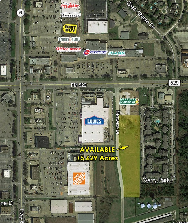


Property Detail
15435 Fm 529 Rd
1382910020001
RES A BLK 2 RESERVES AT FM 529 & KENTWICK
Outdoorrecreationbeachmountaindesert
HARRIS
B and X Area of moderate flood hazard, usually the area between the limits of the 100-year and 500-year floods.
Texas
2024
5.63 AC
2025
FM 1960/Hwy 249
540602
Houston
2,750 SF
Houston-Pasadena-The Woodlands, TX
NEARBY LISTINGS FOR SALE OR LEASE
DEMOGRAPHICS near 15435 Fm 529 Rd
1 mile
3 mile
5 mile
2025 Total Population
16,796
141,783
314,626
2030 Population
17,831
149,395
332,250
Pop Growth 2025-2030
+ 6.16%
+ 5.37%
+ 5.60%
Average Age
38
37
37
2025 Total Households
5,833
47,849
104,419
HH Growth 2025-2030
+ 6.36%
+ 5.59%
+ 5.78%
Median Household Inc
$101,680
$82,248
$88,107
Avg Household Size
2.80
2.90
3.00
2025 Avg HH Vehicles
2.00
2.00
2.00
Median Home Value
$274,081
$267,576
$282,807
Median Year Built
1989
1991
1997
Nearby Places
Map Layers
Map Styles
 Street
 Aerial
Layers
 Traffic
 Biking
Places
Listings with unknown addresses are not visible on the map
- Restaurants
- Banks
- Shops
- Fitness
- Groceries
PUBLIC TRANSPORTATION
AIRPORT
George Bush Intcntl/Houston
Drive
Walk
Distance
George Bush Intcntl/Houston
34 min
26.9 mi
William P Hobby
Drive
Walk
Distance
William P Hobby
49 min
35.0 mi
SALE & LEASE HISTORY
LISTING DATE
SALE/LEASE

Sep 26, 2018
For Sale
May 12, 2017
For Sale
Nearby Properties
Address
Land Use
TOTAL SIZE
Lot Size
Zoning
Address
Land Use
TOTAL SIZE
Lot Size
Zoning
697,158 SF
Address
Land Use
TOTAL SIZE
Lot Size
Zoning
386,642 SF
14.45 AC
Address
Land Use
TOTAL SIZE
Lot Size
Zoning
466,299 SF
23.82 AC
Address
Land Use
TOTAL SIZE
Lot Size
Zoning
120.78 AC
Address
Land Use
TOTAL SIZE
Lot Size
Zoning
373,516 SF
18.63 AC
Address
Land Use
TOTAL SIZE
Lot Size
Zoning
358,713 SF
19.91 AC
Address
Land Use
TOTAL SIZE
Lot Size
Zoning
320,084 SF
8.01 AC
Address
Land Use
TOTAL SIZE
Lot Size
Zoning
307,698 SF
13.12 AC
Address
Land Use
TOTAL SIZE
Lot Size
Zoning
387,245 SF
18.18 AC
Address
Land Use
TOTAL SIZE
Lot Size
Zoning
408,144 SF
26.13 AC
Address
Land Use
TOTAL SIZE
Lot Size
Zoning
418,572 SF
24.76 AC
Address
Land Use
TOTAL SIZE
Lot Size
Zoning
392,185 SF
30.73 AC
Address
Land Use
TOTAL SIZE
Lot Size
Zoning
491,051 SF
50 AC
Address
Land Use
TOTAL SIZE
Lot Size
Zoning
388,223 SF
14.99 AC
Address
Land Use
TOTAL SIZE
Lot Size
Zoning
384,280 SF
27.19 AC
Address
Land Use
TOTAL SIZE
Lot Size
Zoning
363,896 SF
21.69 AC
Address
Land Use
TOTAL SIZE
Lot Size
Zoning
412,250 SF
45.79 AC
Address
Land Use
TOTAL SIZE
Lot Size
Zoning
364,057 SF
22.03 AC
Address
Land Use
TOTAL SIZE
Lot Size
Zoning
112,440 SF
8.02 AC
Address
Land Use
TOTAL SIZE
Lot Size
Zoning
301,102 SF
12.58 AC
Address
Land Use
TOTAL SIZE
Lot Size
Zoning
342,196 SF
15.13 AC
Address
Land Use
TOTAL SIZE
Lot Size
Zoning
493,233 SF
25.82 AC
Address
Land Use
TOTAL SIZE
Lot Size
Zoning
232,717 SF
10.21 AC
Address
Land Use
TOTAL SIZE
Lot Size
Zoning
292,466 SF
12.18 AC
Address
Land Use
TOTAL SIZE
Lot Size
Zoning
312,939 SF
22.80 AC
Address
Land Use
TOTAL SIZE
Lot Size
Zoning
351,468 SF
16.05 AC
Address
Land Use
TOTAL SIZE
Lot Size
Zoning
324,733 SF
19.26 AC
Address
Land Use
TOTAL SIZE
Lot Size
Zoning
215,773 SF
15.71 AC
Address
Land Use
TOTAL SIZE
Lot Size
Zoning
300,000 SF
20.07 AC
Address
Land Use
TOTAL SIZE
Lot Size
Zoning
250,178 SF
The World's #1 Commercial Real Estate Marketplace
Connect with us
© 2026 CoStar Group
The information above has been obtained from sources believed reliable. While we do not doubt its accuracy we have not verified it and make no guarantee, warranty or representation about it. It is your responsibility to independently confirm its accuracy and completeness. Any projections, opinions, assumptions, or estimates used are for example only and do not represent the current or future performance of the property. The value of this transaction to you depends on tax and other factors which should be evaluated by your tax, financial, and legal advisors. You and your advisors should conduct a careful, independent investigation of the property to determine to your satisfaction the suitability of the property for your needs.