Property Record
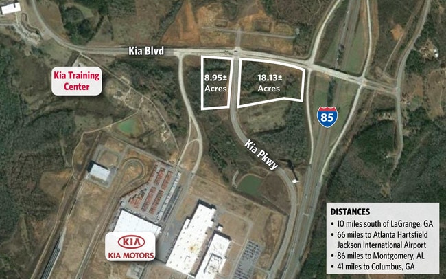
Kia Blvd, West Point, GA 31833
NEARBY LISTINGS FOR SALE OR LEASE
Property Detail
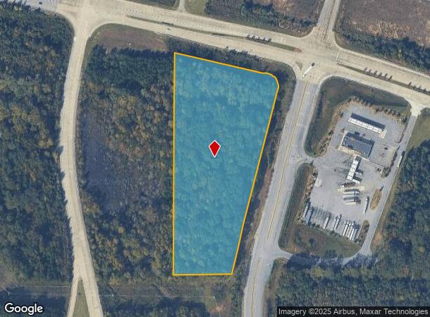
Kia Blvd
LaGrange, GA
Bartley Road Estates (1-2)
077-0-000-031B
KIA BLVD/TR-3B PB74 PG75
Commercialacreage
Troup
X
Georgia
13285C0240E
8.95 AC
2024
Troup County
2025
Columbus GA
120198
DEMOGRAPHICS near Kia Blvd
1 Mile
3 Mile
5 Mile
2024 Total Population
360
2,406
7,216
2029 Population
372
2,464
7,416
Pop Growth 2024-2029
+ 3.33%
+ 2.41%
+ 2.77%
Average Age
39
39
40
2024 Total Households
127
882
2,771
HH Growth 2024-2029
+ 3.15%
+ 2.61%
+ 2.85%
Median Household Inc
$49,658
$49,005
$49,294
Avg Household Size
2.70
2.60
2.50
2024 Avg HH Vehicles
2.00
2.00
2.00
Median Home Value
$164,285
$158,556
$173,462
Median Year Built
1993
1989
1986
Nearby Places
Map Layers
Map Styles
 Street
 Aerial
- Restaurants
- Banks
- Shops
- Fitness
- Groceries
PUBLIC TRANSPORTATION
AIRPORT
Columbus
DRIVE
WALK
Distance
Columbus
49 min
37.6 mi
SALE & LEASE HISTORY
LISTING DATE
SALE/LEASE

Sep 24, 2016
For Sale
Nearby Properties
Address
Land Use
TOTAL SIZE
Lot Size
Zoning
Address
Land Use
TOTAL SIZE
Lot Size
Zoning
415,440 SF
2,257.11 AC
17-I-1
Address
Land Use
TOTAL SIZE
Lot Size
Zoning
517,521 SF
27.03 AC
17-I-1
Address
Land Use
TOTAL SIZE
Lot Size
Zoning
255,952 SF
2.99 AC
17-I-1
Address
Land Use
TOTAL SIZE
Lot Size
Zoning
311,435 SF
2.78 AC
17-I-1
Address
Land Use
TOTAL SIZE
Lot Size
Zoning
307,800 SF
49.87 AC
17-MXD-1
Address
Land Use
TOTAL SIZE
Lot Size
Zoning
426,400 SF
9.82 AC
17-I-1
Address
Land Use
TOTAL SIZE
Lot Size
Zoning
Address
Land Use
TOTAL SIZE
Lot Size
Zoning
132,260 SF
4.03 AC
Address
Land Use
TOTAL SIZE
Lot Size
Zoning
132,600 SF
4.63 AC
Address
Land Use
TOTAL SIZE
Lot Size
Zoning
154,930 SF
73.75 AC
01-SFMD
Address
Land Use
TOTAL SIZE
Lot Size
Zoning
70,000 SF
7.36 AC
17-I-1
Address
Land Use
TOTAL SIZE
Lot Size
Zoning
160.49 AC
17-R-1
Address
Land Use
TOTAL SIZE
Lot Size
Zoning
75,684 SF
5.28 AC
17-MXD-1
Address
Land Use
TOTAL SIZE
Lot Size
Zoning
63,804 SF
8.60 AC
17-MXD-1
Address
Land Use
TOTAL SIZE
Lot Size
Zoning
57.63 AC
01-SFMD
Address
Land Use
TOTAL SIZE
Lot Size
Zoning
62,262 SF
25 AC
01-SFMD
Address
Land Use
TOTAL SIZE
Lot Size
Zoning
7,310 SF
6 AC
17-CGN
Address
Land Use
TOTAL SIZE
Lot Size
Zoning
29,327 SF
1.13 AC
17-MXD-1
Address
Land Use
TOTAL SIZE
Lot Size
Zoning
117.38 AC
17-R-1
Address
Land Use
TOTAL SIZE
Lot Size
Zoning
70.58 AC
17-CGN
Address
Land Use
TOTAL SIZE
Lot Size
Zoning
22.17 AC
17-CGN
Address
Land Use
TOTAL SIZE
Lot Size
Zoning
44,375 SF
6.51 AC
17-MXD-1
Address
Land Use
TOTAL SIZE
Lot Size
Zoning
79.93 AC
17-MXD-1
Address
Land Use
TOTAL SIZE
Lot Size
Zoning
19,008 SF
1.10 AC
17-MXD-1
Address
Land Use
TOTAL SIZE
Lot Size
Zoning
538.57 AC
01-SFMD
Address
Land Use
TOTAL SIZE
Lot Size
Zoning
29,327 SF
64.91 AC
17-MXD-1
Address
Land Use
TOTAL SIZE
Lot Size
Zoning
307.19 AC
16- CP-GI
Address
Land Use
TOTAL SIZE
Lot Size
Zoning
8,820 SF
1.57 AC
17-CGN
Address
Land Use
TOTAL SIZE
Lot Size
Zoning
11,019 SF
2 AC
01-GC
Address
Land Use
TOTAL SIZE
Lot Size
Zoning
64.83 AC
01-SFMD
The World's #1 Commercial Real Estate Marketplace
Connect with us
© 2025 CoStar Group
The information above has been obtained from sources believed reliable. While we do not doubt its accuracy we have not verified it and make no guarantee, warranty or representation about it. It is your responsibility to independently confirm its accuracy and completeness. Any projections, opinions, assumptions, or estimates used are for example only and do not represent the current or future performance of the property. The value of this transaction to you depends on tax and other factors which should be evaluated by your tax, financial, and legal advisors. You and your advisors should conduct a careful, independent investigation of the property to determine to your satisfaction the suitability of the property for your needs.