Property Record
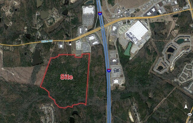
Killian Rd, Columbia, SC 29203

Property Detail
Killian Rd
14600-03-16
#PR 50-6201
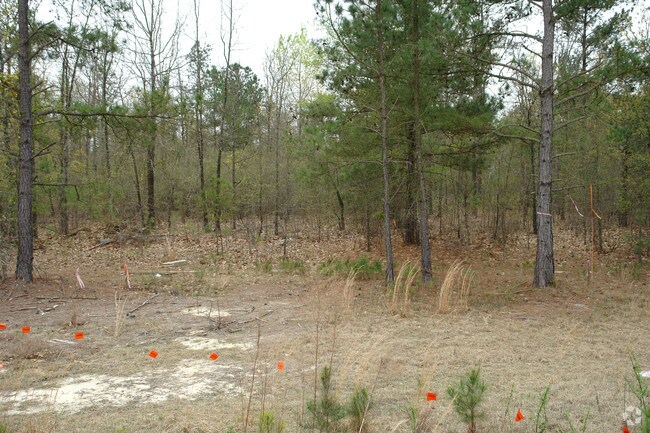
Agriculturalland
RICHLAND
GC
South Carolina
AE The base floodplain where base flood elevations are provided. AE Zones are now used on new format FIRMs instead of A1-A30 Zones.
161.81 AC
2025
Northeast Columbia
2024
Columbia
010701
Columbia, SC
NEARBY LISTINGS FOR SALE OR LEASE
DEMOGRAPHICS near Killian Rd
1 mile
3 mile
5 mile
2025 Total Population
478
28,846
95,900
2030 Population
490
29,999
99,256
Pop Growth 2025-2030
+ 2.51%
+ 4.00%
+ 3.50%
Average Age
39
37
39
2025 Total Households
211
11,328
37,930
HH Growth 2025-2030
+ 2.37%
+ 4.11%
+ 3.57%
Median Household Inc
$47,500
$67,163
$66,194
Avg Household Size
2.10
2.40
2.50
2025 Avg HH Vehicles
2.00
2.00
2.00
Median Home Value
$173,147
$244,323
$241,553
Median Year Built
1999
2002
1997
Nearby Places
Map Layers
Map Styles
 Street
 Aerial
Layers
 Traffic
 Biking
Places
Listings with unknown addresses are not visible on the map
- Restaurants
- Banks
- Shops
- Fitness
- Groceries
PUBLIC TRANSPORTATION
AIRPORT
Columbia Metro
Drive
Walk
Distance
Columbia Metro
39 min
23.0 mi
Freight Ports
North Charleston Terminal
Drive
Walk
Distance
North Charleston Terminal
138 min
120.1 mi
SALE & LEASE HISTORY
LISTING DATE
SALE/LEASE

Sep 24, 2016
For Sale
Nearby Properties
Address
Land Use
TOTAL SIZE
Lot Size
Zoning
Address
Land Use
TOTAL SIZE
Lot Size
Zoning
231,760 SF
23.84 AC
M-1
Address
Land Use
TOTAL SIZE
Lot Size
Zoning
144,849 SF
26.14 AC
OI
Address
Land Use
TOTAL SIZE
Lot Size
Zoning
456,536 SF
42.16 AC
M-1
Address
Land Use
TOTAL SIZE
Lot Size
Zoning
83,808 SF
95.58 AC
PDD
Address
Land Use
TOTAL SIZE
Lot Size
Zoning
325,344 SF
71.41 AC
HI
Address
Land Use
TOTAL SIZE
Lot Size
Zoning
234,990 SF
16.50 AC
RM-HD
Address
Land Use
TOTAL SIZE
Lot Size
Zoning
306,612 SF
20.94 AC
GC
Address
Land Use
TOTAL SIZE
Lot Size
Zoning
349,845 SF
23.62 AC
HI
Address
Land Use
TOTAL SIZE
Lot Size
Zoning
301,627 SF
25.08 AC
PDD
Address
Land Use
TOTAL SIZE
Lot Size
Zoning
462,800 SF
104.82 AC
M-1
Address
Land Use
TOTAL SIZE
Lot Size
Zoning
253,136 SF
18.85 AC
PUD-1R
Address
Land Use
TOTAL SIZE
Lot Size
Zoning
147,916 SF
4.69 AC
OI
Address
Land Use
TOTAL SIZE
Lot Size
Zoning
176,878 SF
15.48 AC
PDD
Address
Land Use
TOTAL SIZE
Lot Size
Zoning
51,803 SF
11.99 AC
M-1
Address
Land Use
TOTAL SIZE
Lot Size
Zoning
217,580 SF
32.47 AC
M-1
Address
Land Use
TOTAL SIZE
Lot Size
Zoning
242,894 SF
14.97 AC
RM-HD
Address
Land Use
TOTAL SIZE
Lot Size
Zoning
50,000 SF
18.71 AC
RS-MD
Address
Land Use
TOTAL SIZE
Lot Size
Zoning
138,552 SF
12.02 AC
RM-HD
Address
Land Use
TOTAL SIZE
Lot Size
Zoning
46,032 SF
11.11 AC
RM-HD
Address
Land Use
TOTAL SIZE
Lot Size
Zoning
148,809 SF
17.52 AC
M-1
Address
Land Use
TOTAL SIZE
Lot Size
Zoning
111,327 SF
7.96 AC
RM-HD
Address
Land Use
TOTAL SIZE
Lot Size
Zoning
129,017 SF
14.70 AC
PDD
Address
Land Use
TOTAL SIZE
Lot Size
Zoning
71,394 SF
12.05 AC
M-1
Address
Land Use
TOTAL SIZE
Lot Size
Zoning
72,938 SF
3.22 AC
M-1
Address
Land Use
TOTAL SIZE
Lot Size
Zoning
133,348 SF
18 AC
M-1
Address
Land Use
TOTAL SIZE
Lot Size
Zoning
80,000 SF
4.77 AC
M-1
Address
Land Use
TOTAL SIZE
Lot Size
Zoning
75,893 SF
10 AC
PDD
Address
Land Use
TOTAL SIZE
Lot Size
Zoning
88,710 SF
3.13 AC
GC
Address
Land Use
TOTAL SIZE
Lot Size
Zoning
68,091 SF
4.35 AC
OI
Address
Land Use
TOTAL SIZE
Lot Size
Zoning
55,747 SF
5.80 AC
M-1
The World's #1 Commercial Real Estate Marketplace
Connect with us
© 2026 CoStar Group
The information above has been obtained from sources believed reliable. While we do not doubt its accuracy we have not verified it and make no guarantee, warranty or representation about it. It is your responsibility to independently confirm its accuracy and completeness. Any projections, opinions, assumptions, or estimates used are for example only and do not represent the current or future performance of the property. The value of this transaction to you depends on tax and other factors which should be evaluated by your tax, financial, and legal advisors. You and your advisors should conduct a careful, independent investigation of the property to determine to your satisfaction the suitability of the property for your needs.