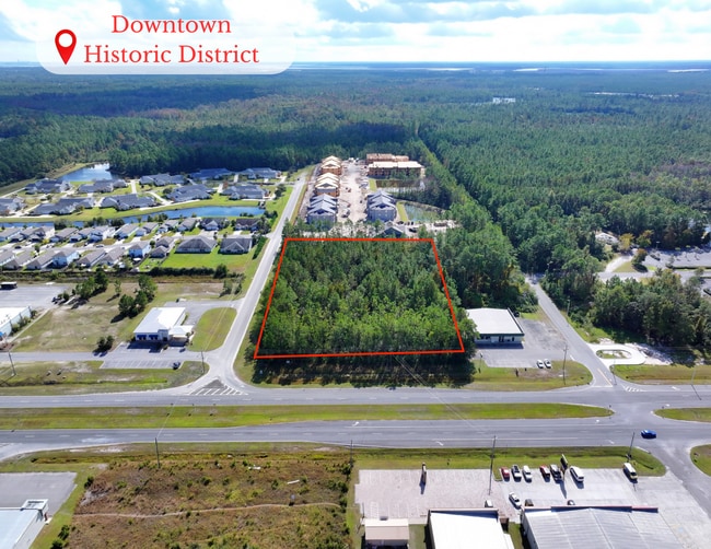
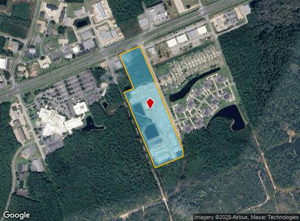
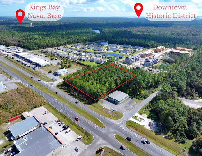
Property Record
Barrier Island Rd, Saint Marys, GA 31558

This Property Is For Sale
NEARBY LISTINGS FOR SALE OR LEASE
Property Detail
Barrier Island Rd
St. Marys, GA
121-1 Ac
121-059
V/L 3 THE VILLAGE AT KINGS BAY
Commercialacreage
Camden
X
Georgia
13039C0415G
14.96 AC
2025
Brunswick/Kingsland
2025
Other Market Areas
010500
DEMOGRAPHICS near Barrier Island Rd
1 Mile
3 Mile
5 Mile
2024 Total Population
1,978
26,006
41,555
2029 Population
2,146
27,967
44,803
Pop Growth 2024-2029
+ 8.49%
+ 7.54%
+ 7.82%
Average Age
35
36
36
2024 Total Households
797
9,504
15,185
HH Growth 2024-2029
+ 8.53%
+ 7.80%
+ 8.09%
Median Household Inc
$45,385
$78,846
$72,989
Avg Household Size
2.40
2.60
2.60
2024 Avg HH Vehicles
2.00
2.00
2.00
Median Home Value
$259,574
$287,463
$282,817
Median Year Built
1996
1999
1997
Nearby Places
- Restaurants
- Banks
- Shops
- Fitness
- Groceries
PUBLIC TRANSPORTATION
AIRPORT
Jacksonville International
DRIVE
WALK
Distance
Jacksonville International
39 min
29.1 mi
Freight Ports
Georgia Ports - Brunswick
DRIVE
WALK
Distance
Georgia Ports - Brunswick
44 min
33.2 mi
Nearby Properties
Address
Land Use
TOTAL SIZE
Lot Size
Zoning
Address
Land Use
TOTAL SIZE
Lot Size
Zoning
2,856 SF
51.84 AC
R-3
Address
Land Use
TOTAL SIZE
Lot Size
Zoning
172,807 SF
45.10 AC
R-1
Address
Land Use
TOTAL SIZE
Lot Size
Zoning
1,456 SF
15.71 AC
R-3
Address
Land Use
TOTAL SIZE
Lot Size
Zoning
144,338 SF
35 AC
R-1
Address
Land Use
TOTAL SIZE
Lot Size
Zoning
26,410 SF
3.21 AC
C-3
Address
Land Use
TOTAL SIZE
Lot Size
Zoning
80,350 SF
28 AC
PD
Address
Land Use
TOTAL SIZE
Lot Size
Zoning
14,152 SF
14.25 AC
R-3
Address
Land Use
TOTAL SIZE
Lot Size
Zoning
79,447 SF
25 AC
PD/R-1
Address
Land Use
TOTAL SIZE
Lot Size
Zoning
64,504 SF
20 AC
C-ED
Address
Land Use
TOTAL SIZE
Lot Size
Zoning
64,810 SF
21 AC
R-1
Address
Land Use
TOTAL SIZE
Lot Size
Zoning
87,534 SF
25 AC
PD
Address
Land Use
TOTAL SIZE
Lot Size
Zoning
2,305 SF
20.92 AC
C-2
Address
Land Use
TOTAL SIZE
Lot Size
Zoning
123,108 SF
11.83 AC
R-3
Address
Land Use
TOTAL SIZE
Lot Size
Zoning
5 AC
C-3
Address
Land Use
TOTAL SIZE
Lot Size
Zoning
28,858 SF
5.09 AC
R-3
Address
Land Use
TOTAL SIZE
Lot Size
Zoning
3,240 SF
13.97 AC
R-1
Address
Land Use
TOTAL SIZE
Lot Size
Zoning
8,544 SF
18.64 AC
C2
Address
Land Use
TOTAL SIZE
Lot Size
Zoning
139,255 SF
16.27 AC
I-L
Address
Land Use
TOTAL SIZE
Lot Size
Zoning
31,428 SF
5.80 AC
R-2
Address
Land Use
TOTAL SIZE
Lot Size
Zoning
16,598 SF
24.13 AC
PD/R-3
Address
Land Use
TOTAL SIZE
Lot Size
Zoning
95,196 SF
8.64 AC
C2
Address
Land Use
TOTAL SIZE
Lot Size
Zoning
2,833 SF
22.34 AC
PD/C2
Address
Land Use
TOTAL SIZE
Lot Size
Zoning
182,489 SF
22.88 AC
C-2
Address
Land Use
TOTAL SIZE
Lot Size
Zoning
77,912 SF
12.76 AC
C-2
Address
Land Use
TOTAL SIZE
Lot Size
Zoning
22,311 SF
6.39 AC
C-2
Address
Land Use
TOTAL SIZE
Lot Size
Zoning
3,000 SF
8.78 AC
C-2
Address
Land Use
TOTAL SIZE
Lot Size
Zoning
626.23 AC
P-D
Address
Land Use
TOTAL SIZE
Lot Size
Zoning
51,948 SF
2.08 AC
C-4
Address
Land Use
TOTAL SIZE
Lot Size
Zoning
55,497 SF
1.68 AC
C-4
Address
Land Use
TOTAL SIZE
Lot Size
Zoning
16,768 SF
8.96 AC
R-3
The World's #1 Commercial Real Estate Marketplace
Connect with us
© 2025 CoStar Group
The information above has been obtained from sources believed reliable. While we do not doubt its accuracy we have not verified it and make no guarantee, warranty or representation about it. It is your responsibility to independently confirm its accuracy and completeness. Any projections, opinions, assumptions, or estimates used are for example only and do not represent the current or future performance of the property. The value of this transaction to you depends on tax and other factors which should be evaluated by your tax, financial, and legal advisors. You and your advisors should conduct a careful, independent investigation of the property to determine to your satisfaction the suitability of the property for your needs.