Property Record
Kings Bay Rd, Saint Marys, GA 31558
NEARBY LISTINGS FOR SALE OR LEASE
Property Detail
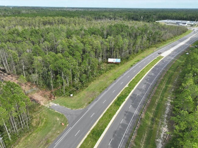
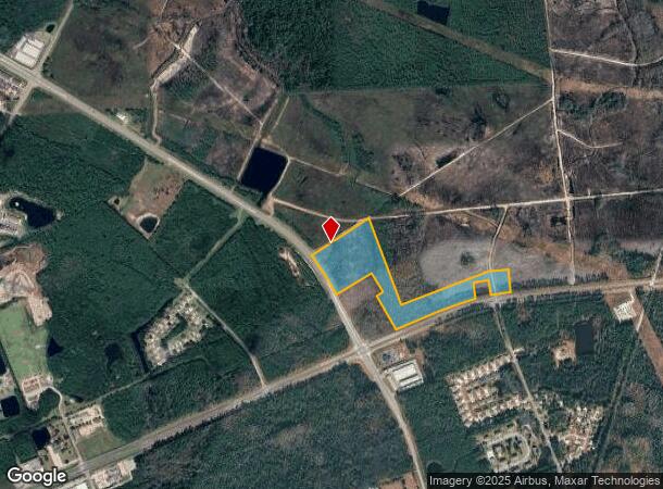
Kings Bay Rd
St. Marys, GA
New10
134-009
V/L COLERAIN-KINGS BAY RD
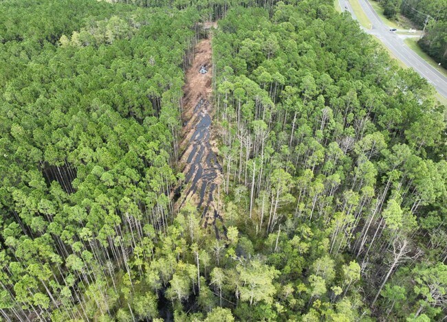
Privatepreserveopenspacevacantlandforestlandconservation
Camden
X
Georgia
13039C0415G
25 AC
2025
Brunswick/Kingsland
2025
Other Market Areas
010500
DEMOGRAPHICS near Kings Bay Rd
1 Mile
3 Mile
5 Mile
2024 Total Population
1,777
23,213
38,035
2029 Population
1,989
25,442
41,690
Pop Growth 2024-2029
+ 11.93%
+ 9.60%
+ 9.61%
Average Age
34
34
36
2024 Total Households
750
7,988
13,663
HH Growth 2024-2029
+ 12.00%
+ 9.85%
+ 9.80%
Median Household Inc
$39,447
$67,407
$68,467
Avg Household Size
2.30
2.60
2.60
2024 Avg HH Vehicles
2.00
2.00
2.00
Median Home Value
$220,000
$238,295
$238,169
Median Year Built
1995
1998
1996
Nearby Places
Map Layers
Map Styles
 Street
 Aerial
- Restaurants
- Banks
- Shops
- Fitness
- Groceries
PUBLIC TRANSPORTATION
AIRPORT
Jacksonville International
DRIVE
WALK
Distance
Jacksonville International
40 min
30.1 mi
Freight Ports
Georgia Ports - Brunswick
DRIVE
WALK
Distance
Georgia Ports - Brunswick
42 min
32.0 mi
SALE & LEASE HISTORY
LISTING DATE
SALE/LEASE

Oct 05, 2022
For Sale
Nearby Properties
Address
Land Use
TOTAL SIZE
Lot Size
Zoning
Address
Land Use
TOTAL SIZE
Lot Size
Zoning
2,856 SF
51.84 AC
R-3
Address
Land Use
TOTAL SIZE
Lot Size
Zoning
1,456 SF
15.71 AC
R-3
Address
Land Use
TOTAL SIZE
Lot Size
Zoning
144,338 SF
35 AC
R-1
Address
Land Use
TOTAL SIZE
Lot Size
Zoning
26,410 SF
3.21 AC
C-3
Address
Land Use
TOTAL SIZE
Lot Size
Zoning
80,350 SF
28 AC
PD
Address
Land Use
TOTAL SIZE
Lot Size
Zoning
14,152 SF
14.25 AC
R-3
Address
Land Use
TOTAL SIZE
Lot Size
Zoning
64,504 SF
20 AC
C-ED
Address
Land Use
TOTAL SIZE
Lot Size
Zoning
64,810 SF
21 AC
R-1
Address
Land Use
TOTAL SIZE
Lot Size
Zoning
87,534 SF
25 AC
PD
Address
Land Use
TOTAL SIZE
Lot Size
Zoning
2,305 SF
20.92 AC
C-2
Address
Land Use
TOTAL SIZE
Lot Size
Zoning
123,108 SF
11.83 AC
R-3
Address
Land Use
TOTAL SIZE
Lot Size
Zoning
5 AC
C-3
Address
Land Use
TOTAL SIZE
Lot Size
Zoning
28,858 SF
5.09 AC
R-3
Address
Land Use
TOTAL SIZE
Lot Size
Zoning
3,240 SF
13.97 AC
R-1
Address
Land Use
TOTAL SIZE
Lot Size
Zoning
8,544 SF
18.64 AC
C2
Address
Land Use
TOTAL SIZE
Lot Size
Zoning
139,255 SF
16.27 AC
I-L
Address
Land Use
TOTAL SIZE
Lot Size
Zoning
31,428 SF
5.80 AC
R-2
Address
Land Use
TOTAL SIZE
Lot Size
Zoning
16,598 SF
24.13 AC
PD/R-3
Address
Land Use
TOTAL SIZE
Lot Size
Zoning
95,196 SF
8.64 AC
C2
Address
Land Use
TOTAL SIZE
Lot Size
Zoning
2,833 SF
22.34 AC
PD/C2
Address
Land Use
TOTAL SIZE
Lot Size
Zoning
182,489 SF
22.88 AC
C-2
Address
Land Use
TOTAL SIZE
Lot Size
Zoning
22,311 SF
6.39 AC
C-2
Address
Land Use
TOTAL SIZE
Lot Size
Zoning
3,000 SF
8.78 AC
C-2
Address
Land Use
TOTAL SIZE
Lot Size
Zoning
16,768 SF
8.96 AC
R-3
Address
Land Use
TOTAL SIZE
Lot Size
Zoning
56,037 SF
8.66 AC
C2
Address
Land Use
TOTAL SIZE
Lot Size
Zoning
3,712 SF
4.12 AC
PD/C-2
Address
Land Use
TOTAL SIZE
Lot Size
Zoning
45,180 SF
7.46 AC
C-2
Address
Land Use
TOTAL SIZE
Lot Size
Zoning
1,530 SF
5.97 AC
C-2
Address
Land Use
TOTAL SIZE
Lot Size
Zoning
6,720 SF
25 AC
R-3
Address
Land Use
TOTAL SIZE
Lot Size
Zoning
18,025 SF
12.47 AC
C-2
The World's #1 Commercial Real Estate Marketplace
Connect with us
© 2025 CoStar Group
The information above has been obtained from sources believed reliable. While we do not doubt its accuracy we have not verified it and make no guarantee, warranty or representation about it. It is your responsibility to independently confirm its accuracy and completeness. Any projections, opinions, assumptions, or estimates used are for example only and do not represent the current or future performance of the property. The value of this transaction to you depends on tax and other factors which should be evaluated by your tax, financial, and legal advisors. You and your advisors should conduct a careful, independent investigation of the property to determine to your satisfaction the suitability of the property for your needs.