Property Record
0 Hargraves Rd, Huffman, TX 77336
NEARBY LISTINGS FOR SALE OR LEASE
Property Detail
0 Hargraves Rd
Houston-The Woodlands-Sugar Land, TX
Plantations
1236630010013
RES A BLK 1 PLANTATIONS
Vacantlandnec
Harris
X
Texas
48291C0400C
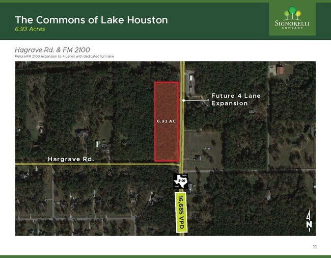
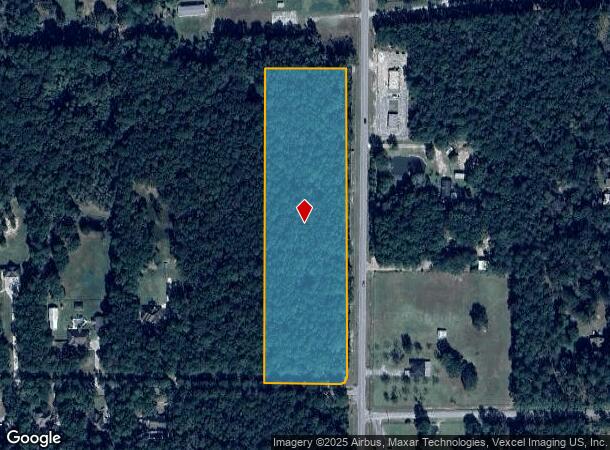
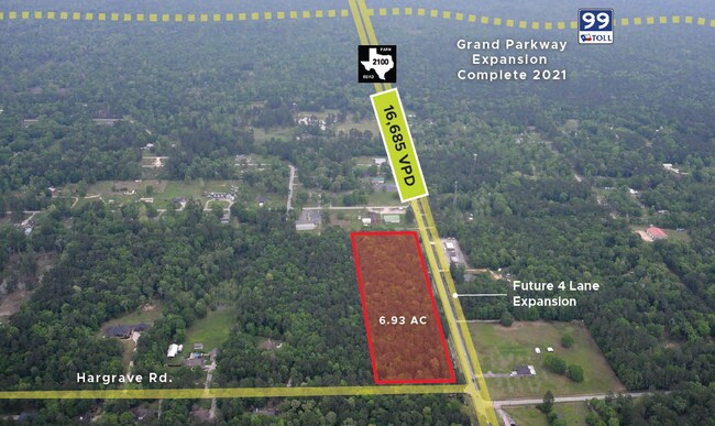
6.93 AC
2024
Kingwood/Humble
2025
Houston
251600
DEMOGRAPHICS near 0 Hargraves Rd
1 Mile
3 Mile
5 Mile
2024 Total Population
1,415
8,109
42,558
2029 Population
1,459
8,471
46,045
Pop Growth 2024-2029
+ 3.11%
+ 4.46%
+ 8.19%
Average Age
40
40
38
2024 Total Households
472
2,692
13,467
HH Growth 2024-2029
+ 2.97%
+ 4.49%
+ 7.68%
Median Household Inc
$82,639
$89,152
$115,218
Avg Household Size
2.90
2.90
3.10
2024 Avg HH Vehicles
2.00
2.00
2.00
Median Home Value
$252,027
$294,022
$321,376
Median Year Built
2001
2001
1996
Nearby Places
- Restaurants
- Banks
- Shops
- Fitness
- Groceries
PUBLIC TRANSPORTATION
AIRPORT
George Bush Intcntl/Houston
DRIVE
WALK
Distance
George Bush Intcntl/Houston
38 min
27.8 mi
Freight Ports
Port of Houston
DRIVE
WALK
Distance
Port of Houston
56 min
34.5 mi
SALE & LEASE HISTORY
LISTING DATE
SALE/LEASE

May 06, 2025
For Sale
Aug 25, 2020
For Sale
Nearby Properties
Address
Land Use
TOTAL SIZE
Lot Size
Zoning
Address
Land Use
TOTAL SIZE
Lot Size
Zoning
11,648 SF
7.30 AC
Address
Land Use
TOTAL SIZE
Lot Size
Zoning
715.51 AC
Address
Land Use
TOTAL SIZE
Lot Size
Zoning
1,049.13 AC
Address
Land Use
TOTAL SIZE
Lot Size
Zoning
298.07 AC
Address
Land Use
TOTAL SIZE
Lot Size
Zoning
3,200 SF
5.10 AC
Address
Land Use
TOTAL SIZE
Lot Size
Zoning
8,526 SF
1.77 AC
Address
Land Use
TOTAL SIZE
Lot Size
Zoning
33.96 AC
Address
Land Use
TOTAL SIZE
Lot Size
Zoning
56.28 AC
Address
Land Use
TOTAL SIZE
Lot Size
Zoning
184.01 AC
Address
Land Use
TOTAL SIZE
Lot Size
Zoning
9,100 SF
2.51 AC
Address
Land Use
TOTAL SIZE
Lot Size
Zoning
29.18 AC
Address
Land Use
TOTAL SIZE
Lot Size
Zoning
6,637 SF
7.49 AC
Address
Land Use
TOTAL SIZE
Lot Size
Zoning
50.10 AC
Address
Land Use
TOTAL SIZE
Lot Size
Zoning
449.41 AC
Address
Land Use
TOTAL SIZE
Lot Size
Zoning
1,536 SF
16.77 AC
Address
Land Use
TOTAL SIZE
Lot Size
Zoning
163.13 AC
Address
Land Use
TOTAL SIZE
Lot Size
Zoning
4.24 AC
Address
Land Use
TOTAL SIZE
Lot Size
Zoning
39.92 AC
Address
Land Use
TOTAL SIZE
Lot Size
Zoning
1,216 SF
367.65 AC
Address
Land Use
TOTAL SIZE
Lot Size
Zoning
387.63 AC
Address
Land Use
TOTAL SIZE
Lot Size
Zoning
26.43 AC
Address
Land Use
TOTAL SIZE
Lot Size
Zoning
138.16 AC
Address
Land Use
TOTAL SIZE
Lot Size
Zoning
Address
Land Use
TOTAL SIZE
Lot Size
Zoning
Address
Land Use
TOTAL SIZE
Lot Size
Zoning
Address
Land Use
TOTAL SIZE
Lot Size
Zoning
178.47 AC
Address
Land Use
TOTAL SIZE
Lot Size
Zoning
Address
Land Use
TOTAL SIZE
Lot Size
Zoning
3,600 SF
5 AC
Address
Land Use
TOTAL SIZE
Lot Size
Zoning
12.60 AC
Address
Land Use
TOTAL SIZE
Lot Size
Zoning
The World's #1 Commercial Real Estate Marketplace
Connect with us
© 2025 CoStar Group
The information above has been obtained from sources believed reliable. While we do not doubt its accuracy we have not verified it and make no guarantee, warranty or representation about it. It is your responsibility to independently confirm its accuracy and completeness. Any projections, opinions, assumptions, or estimates used are for example only and do not represent the current or future performance of the property. The value of this transaction to you depends on tax and other factors which should be evaluated by your tax, financial, and legal advisors. You and your advisors should conduct a careful, independent investigation of the property to determine to your satisfaction the suitability of the property for your needs.