Property Record
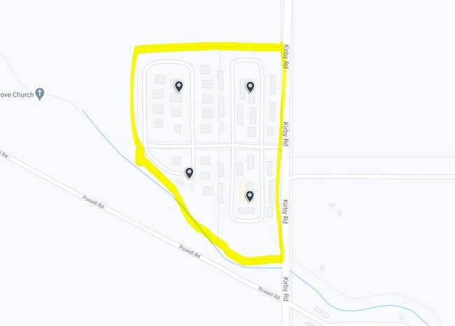
Kirby Rd, Robinsonville, MS 38664

Property Detail
Kirby Rd
3108280000000401
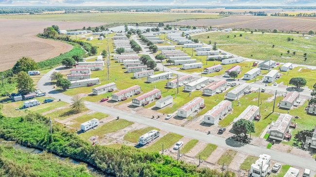
BUCK ISLAND MANUFACTURE HOUSING PARK PARCEL A SW1/4 SW1/4
Laundromat
TUNICA
C and X Area of minimal flood hazard, usually depicted on FIRMs as above the 500-year flood level.
Mississippi
2025
34 AC
2025
Robinsonville-Tunica
950102
Memphis
486 SF
Memphis, TN-MS-AR
NEARBY LISTINGS FOR SALE OR LEASE
-
-
View all Robinsonville listings for sale on LoopNet.com
DEMOGRAPHICS near Kirby Rd
1 mile
3 mile
5 mile
2025 Total Population
1,208
1,670
3,824
2030 Population
1,225
1,660
3,801
Pop Growth 2025-2030
+ 1.41%
(0.60%)
(0.60%)
Average Age
31
32
36
2025 Total Households
419
630
1,540
HH Growth 2025-2030
+ 1.67%
(0.95%)
(0.84%)
Median Household Inc
$20,250
$30,170
$39,513
Avg Household Size
2.90
2.70
2.50
2025 Avg HH Vehicles
1.00
1.00
2.00
Median Home Value
$80,882
$142,105
$206,626
Median Year Built
1993
1996
1996
Nearby Places
Map Layers
Map Styles
 Street
 Aerial
Layers
 Traffic
 Biking
Places
Listings with unknown addresses are not visible on the map
- Restaurants
- Banks
- Shops
- Fitness
- Groceries
PUBLIC TRANSPORTATION
AIRPORT
Memphis International
Drive
Walk
Distance
Memphis International
43 min
28.2 mi
Freight Ports
Port of Shreveport
Drive
Walk
Distance
Port of Shreveport
416 min
343.9 mi
SALE & LEASE HISTORY
LISTING DATE
SALE/LEASE

Dec 16, 2019
For Sale
Nearby Properties
Address
Land Use
TOTAL SIZE
Lot Size
Zoning
Address
Land Use
TOTAL SIZE
Lot Size
Zoning
7.40 AC
Address
Land Use
TOTAL SIZE
Lot Size
Zoning
12,643 SF
100 AC
Address
Land Use
TOTAL SIZE
Lot Size
Zoning
2,325 SF
12.60 AC
Address
Land Use
TOTAL SIZE
Lot Size
Zoning
33,828 SF
1.50 AC
Address
Land Use
TOTAL SIZE
Lot Size
Zoning
4.40 AC
Address
Land Use
TOTAL SIZE
Lot Size
Zoning
14,993 SF
3.28 AC
Address
Land Use
TOTAL SIZE
Lot Size
Zoning
5.80 AC
Address
Land Use
TOTAL SIZE
Lot Size
Zoning
7.20 AC
Address
Land Use
TOTAL SIZE
Lot Size
Zoning
784 SF
2.20 AC
Address
Land Use
TOTAL SIZE
Lot Size
Zoning
53,340 SF
3.20 AC
Address
Land Use
TOTAL SIZE
Lot Size
Zoning
12,312 SF
1.32 AC
Address
Land Use
TOTAL SIZE
Lot Size
Zoning
37,037 SF
2 AC
Address
Land Use
TOTAL SIZE
Lot Size
Zoning
7,408 SF
1.04 AC
Address
Land Use
TOTAL SIZE
Lot Size
Zoning
3,500 SF
190 AC
Address
Land Use
TOTAL SIZE
Lot Size
Zoning
4,021 SF
10.50 AC
Address
Land Use
TOTAL SIZE
Lot Size
Zoning
1,673 SF
0.97 AC
Address
Land Use
TOTAL SIZE
Lot Size
Zoning
Address
Land Use
TOTAL SIZE
Lot Size
Zoning
Address
Land Use
TOTAL SIZE
Lot Size
Zoning
Address
Land Use
TOTAL SIZE
Lot Size
Zoning
0.18 AC
Address
Land Use
TOTAL SIZE
Lot Size
Zoning
Address
Land Use
TOTAL SIZE
Lot Size
Zoning
Address
Land Use
TOTAL SIZE
Lot Size
Zoning
0.17 AC
Address
Land Use
TOTAL SIZE
Lot Size
Zoning
The World's #1 Commercial Real Estate Marketplace
Connect with us
© 2026 CoStar Group
The information above has been obtained from sources believed reliable. While we do not doubt its accuracy we have not verified it and make no guarantee, warranty or representation about it. It is your responsibility to independently confirm its accuracy and completeness. Any projections, opinions, assumptions, or estimates used are for example only and do not represent the current or future performance of the property. The value of this transaction to you depends on tax and other factors which should be evaluated by your tax, financial, and legal advisors. You and your advisors should conduct a careful, independent investigation of the property to determine to your satisfaction the suitability of the property for your needs.