Property Record
Kirkland Rd, Covington, GA 30016
NEARBY LISTINGS FOR SALE OR LEASE
Property Detail
Kirkland Rd
Atlanta-Sandy Springs-Roswell, GA
Vacant - Commercial
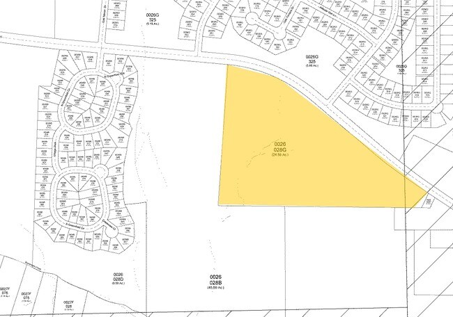
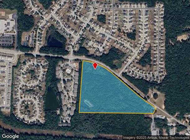
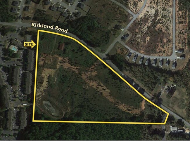
0026000000028G00
24AC KIRKLAND RD
Commercialacreage
Newton
X
Georgia
13217C0108D
24 AC
2025
Newton County
2025
Atlanta
100902
DEMOGRAPHICS near Kirkland Rd
1 mile
3 mile
5 mile
2024 Total Population
4,666
38,896
88,305
2029 Population
5,183
43,059
96,852
Pop Growth 2024-2029
+ 11.08%
+ 10.70%
+ 9.68%
Average Age
36
37
38
2024 Total Households
1,546
13,698
31,224
HH Growth 2024-2029
+ 11.38%
+ 10.97%
+ 9.98%
Median Household Inc
$74,654
$69,182
$72,373
Avg Household Size
2.90
2.80
2.80
2024 Avg HH Vehicles
2.00
2.00
2.00
Median Home Value
$190,475
$168,669
$183,902
Median Year Built
2003
1999
1996
Nearby Places
Map Layers
Map Styles
 Street
 Aerial
Transit
 Traffic
 Biking
Places
Listings with unknown addresses are not visible on the map
- Restaurants
- Banks
- Shops
- Fitness
- Groceries
PUBLIC TRANSPORTATION
AIRPORT
Hartsfield - Jackson Atlanta International
Drive
Walk
Distance
Hartsfield - Jackson Atlanta International
51 min
37.7 mi
Freight Ports
Georgia Ports - Savannah
Drive
Walk
Distance
Georgia Ports - Savannah
273 min
227.8 mi
SALE & LEASE HISTORY
LISTING DATE
SALE/LEASE

Apr 04, 2017
For Sale
Nearby Properties
Address
Land Use
TOTAL SIZE
Lot Size
Zoning
Address
Land Use
TOTAL SIZE
Lot Size
Zoning
4,734 SF
35.19 AC
RMF
Address
Land Use
TOTAL SIZE
Lot Size
Zoning
306,886 SF
118.50 AC
R2
Address
Land Use
TOTAL SIZE
Lot Size
Zoning
1,648 SF
25.08 AC
C1
Address
Land Use
TOTAL SIZE
Lot Size
Zoning
882,960 SF
0.01 AC
Address
Land Use
TOTAL SIZE
Lot Size
Zoning
14,624 SF
26.09 AC
C1
Address
Land Use
TOTAL SIZE
Lot Size
Zoning
19,292 SF
8.20 AC
H1
Address
Land Use
TOTAL SIZE
Lot Size
Zoning
17,056 SF
16.78 AC
C1
Address
Land Use
TOTAL SIZE
Lot Size
Zoning
92,162 SF
11.21 AC
R2
Address
Land Use
TOTAL SIZE
Lot Size
Zoning
5,160 SF
45.17 AC
C1
Address
Land Use
TOTAL SIZE
Lot Size
Zoning
882,960 SF
114.02 AC
M1
Address
Land Use
TOTAL SIZE
Lot Size
Zoning
8,156 SF
14.49 AC
C1
Address
Land Use
TOTAL SIZE
Lot Size
Zoning
8,832 SF
8.26 AC
C1
Address
Land Use
TOTAL SIZE
Lot Size
Zoning
8,632 SF
8.11 AC
C1
Address
Land Use
TOTAL SIZE
Lot Size
Zoning
82,716 SF
21.04 AC
R2
Address
Land Use
TOTAL SIZE
Lot Size
Zoning
125,971 SF
23.84 AC
C1
Address
Land Use
TOTAL SIZE
Lot Size
Zoning
222,056 SF
13.35 AC
Address
Land Use
TOTAL SIZE
Lot Size
Zoning
3,888 SF
7.17 AC
C1
Address
Land Use
TOTAL SIZE
Lot Size
Zoning
65,520 SF
35 AC
E6
Address
Land Use
TOTAL SIZE
Lot Size
Zoning
65,008 SF
23.81 AC
R2
Address
Land Use
TOTAL SIZE
Lot Size
Zoning
151,955 SF
26.17 AC
R1
Address
Land Use
TOTAL SIZE
Lot Size
Zoning
64,799 SF
19.10 AC
E6
Address
Land Use
TOTAL SIZE
Lot Size
Zoning
4,768 SF
263.26 AC
C1
Address
Land Use
TOTAL SIZE
Lot Size
Zoning
6,936 SF
8.88 AC
C1
Address
Land Use
TOTAL SIZE
Lot Size
Zoning
28,512 SF
0.52 AC
Address
Land Use
TOTAL SIZE
Lot Size
Zoning
99,686 SF
11.50 AC
C1
Address
Land Use
TOTAL SIZE
Lot Size
Zoning
38,120 SF
155.15 AC
E1
Address
Land Use
TOTAL SIZE
Lot Size
Zoning
54,712 SF
54.54 AC
E6
Address
Land Use
TOTAL SIZE
Lot Size
Zoning
27,492 SF
0.47 AC
Address
Land Use
TOTAL SIZE
Lot Size
Zoning
101,010 SF
59.60 AC
E6
Address
Land Use
TOTAL SIZE
Lot Size
Zoning
2,460 SF
7 AC
E2
The World's #1 Commercial Real Estate Marketplace
Connect with us
© 2026 CoStar Group
The information above has been obtained from sources believed reliable. While we do not doubt its accuracy we have not verified it and make no guarantee, warranty or representation about it. It is your responsibility to independently confirm its accuracy and completeness. Any projections, opinions, assumptions, or estimates used are for example only and do not represent the current or future performance of the property. The value of this transaction to you depends on tax and other factors which should be evaluated by your tax, financial, and legal advisors. You and your advisors should conduct a careful, independent investigation of the property to determine to your satisfaction the suitability of the property for your needs.