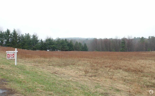
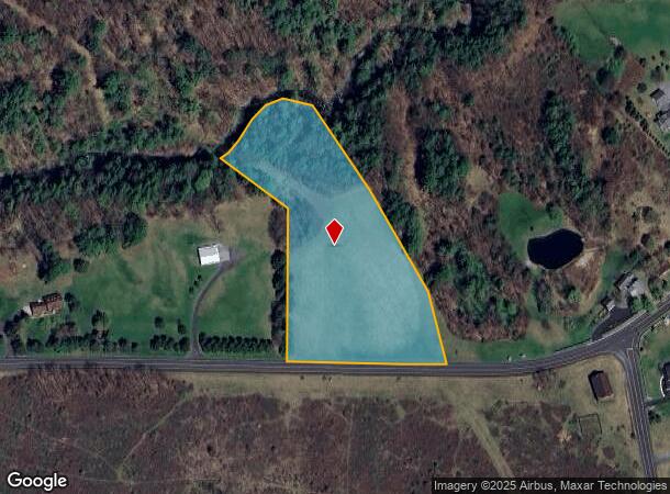
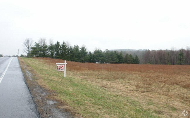
Property Record
Krumkill Rd, Slingerlands, NY 12159
NEARBY LISTINGS FOR SALE OR LEASE
Property Detail
Krumkill Rd
Albany-Schenectady-Troy, NY
1.-64-12.1 KRUMKILL RD PAR #18.22
013489-062-000-0004-018-006-0000
Albany
Residentialacreage
New York
AE
18.006
36001C0167D
4.70 AC
2025
W Outer Albany County
2024
Albany/Schenectady/Troy
014501
DEMOGRAPHICS near Krumkill Rd
1 Mile
3 Mile
5 Mile
2024 Total Population
868
22,870
72,255
2029 Population
868
22,872
72,013
Pop Growth 2024-2029
0.00%
+ 0.01%
(0.33%)
Average Age
43
42
42
2024 Total Households
335
10,077
28,612
HH Growth 2024-2029
+ 0.30%
+ 0.13%
(0.23%)
Median Household Inc
$114,285
$87,640
$91,892
Avg Household Size
2.60
2.20
2.20
2024 Avg HH Vehicles
2.00
2.00
2.00
Median Home Value
$410,227
$313,019
$285,615
Median Year Built
1985
1977
1972
Nearby Places
- Restaurants
- Banks
- Shops
- Fitness
- Groceries
PUBLIC TRANSPORTATION
AIRPORT
Albany International
DRIVE
WALK
Distance
Albany International
24 min
12.0 mi
Freight Ports
Albany, NY Port
DRIVE
WALK
Distance
Albany, NY Port
21 min
11.5 mi
Nearby Properties
Address
Land Use
TOTAL SIZE
Lot Size
Zoning
Address
Land Use
TOTAL SIZE
Lot Size
Zoning
47,424 SF
37.60 AC
MR
Address
Land Use
TOTAL SIZE
Lot Size
Zoning
3,760 SF
28.30 AC
MR
Address
Land Use
TOTAL SIZE
Lot Size
Zoning
349,516 SF
22.61 AC
MED
Address
Land Use
TOTAL SIZE
Lot Size
Zoning
8,600 SF
14.80 AC
MR
Address
Land Use
TOTAL SIZE
Lot Size
Zoning
18,240 SF
26.70 AC
MR
Address
Land Use
TOTAL SIZE
Lot Size
Zoning
22,446 SF
11.30 AC
MR
Address
Land Use
TOTAL SIZE
Lot Size
Zoning
1,584 SF
9.60 AC
MR
Address
Land Use
TOTAL SIZE
Lot Size
Zoning
10,880 SF
13.50 AC
TH
Address
Land Use
TOTAL SIZE
Lot Size
Zoning
75,790 SF
19.23 AC
RO40
Address
Land Use
TOTAL SIZE
Lot Size
Zoning
161,797 SF
13.69 AC
GB
Address
Land Use
TOTAL SIZE
Lot Size
Zoning
14,436 SF
13.20 AC
MR
Address
Land Use
TOTAL SIZE
Lot Size
Zoning
49,889 SF
9.74 AC
MR
Address
Land Use
TOTAL SIZE
Lot Size
Zoning
16,739 SF
14.20 AC
PDD
Address
Land Use
TOTAL SIZE
Lot Size
Zoning
131,716 SF
65.09 AC
RO40
Address
Land Use
TOTAL SIZE
Lot Size
Zoning
121,137 SF
5.92 AC
PUD
Address
Land Use
TOTAL SIZE
Lot Size
Zoning
8,832 SF
6.40 AC
MR
Address
Land Use
TOTAL SIZE
Lot Size
Zoning
60,300 SF
4 AC
MR
Address
Land Use
TOTAL SIZE
Lot Size
Zoning
74,167 SF
8.80 AC
PUD
Address
Land Use
TOTAL SIZE
Lot Size
Zoning
7,856 SF
14.30 AC
MR
Address
Land Use
TOTAL SIZE
Lot Size
Zoning
60,025 SF
20.80 AC
RO40
Address
Land Use
TOTAL SIZE
Lot Size
Zoning
11,516 SF
131 AC
RA3
Address
Land Use
TOTAL SIZE
Lot Size
Zoning
7,148 SF
7.20 AC
PUD
Address
Land Use
TOTAL SIZE
Lot Size
Zoning
69,106 SF
7.80 AC
MED
Address
Land Use
TOTAL SIZE
Lot Size
Zoning
72,741 SF
12.92 AC
CH
Address
Land Use
TOTAL SIZE
Lot Size
Zoning
76,826 SF
20 AC
RA
Address
Land Use
TOTAL SIZE
Lot Size
Zoning
61,006 SF
8.10 AC
R15
Address
Land Use
TOTAL SIZE
Lot Size
Zoning
43,196 SF
12.40 AC
CH
Address
Land Use
TOTAL SIZE
Lot Size
Zoning
3,200 SF
231.30 AC
RA3
Address
Land Use
TOTAL SIZE
Lot Size
Zoning
76,396 SF
19 AC
R15
Address
Land Use
TOTAL SIZE
Lot Size
Zoning
17,388 SF
8.10 AC
PDD
The World's #1 Commercial Real Estate Marketplace
Connect with us
© 2025 CoStar Group
The information above has been obtained from sources believed reliable. While we do not doubt its accuracy we have not verified it and make no guarantee, warranty or representation about it. It is your responsibility to independently confirm its accuracy and completeness. Any projections, opinions, assumptions, or estimates used are for example only and do not represent the current or future performance of the property. The value of this transaction to you depends on tax and other factors which should be evaluated by your tax, financial, and legal advisors. You and your advisors should conduct a careful, independent investigation of the property to determine to your satisfaction the suitability of the property for your needs.