Property Record
Krumsville Rd, , PA


Property Detail
Krumsville Rd
45-5446-03-01-9058
BERKS
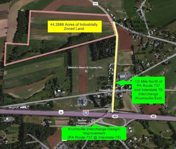
Industrialacreage
Pennsylvania
B and X Area of moderate flood hazard, usually the area between the limits of the 100-year and 500-year floods.
44.04 AC
2025
Berks County
2025
Philadelphia
013900
Reading, PA
NEARBY LISTINGS FOR SALE OR LEASE
-
-
View all listings for sale on LoopNet.com
DEMOGRAPHICS near Krumsville Rd
1 mile
3 mile
5 mile
2025 Total Population
522
4,685
15,916
2030 Population
551
4,912
16,864
Pop Growth 2025-2030
+ 5.56%
+ 4.85%
+ 5.96%
Average Age
45
43
42
2025 Total Households
214
1,748
6,357
HH Growth 2025-2030
+ 5.61%
+ 5.26%
+ 6.32%
Median Household Inc
$108,571
$104,895
$80,548
Avg Household Size
2.50
2.50
2.40
2025 Avg HH Vehicles
2.00
2.00
2.00
Median Home Value
$368,749
$376,542
$330,997
Median Year Built
1991
1989
1979
Nearby Places
Map Layers
Map Styles
 Street
 Aerial
Transit
 Traffic
 Biking
Places
Listings with unknown addresses are not visible on the map
- Restaurants
- Banks
- Shops
- Fitness
- Groceries
PUBLIC TRANSPORTATION
AIRPORT
Lehigh Valley International
Drive
Walk
Distance
Lehigh Valley International
34 min
22.3 mi
Freight Ports
Port of Philadelphia
Drive
Walk
Distance
Port of Philadelphia
92 min
70.6 mi
SALE & LEASE HISTORY
LISTING DATE
SALE/LEASE

Sep 24, 2016
For Sale
Nearby Properties
Address
Land Use
TOTAL SIZE
Lot Size
Zoning
Address
Land Use
TOTAL SIZE
Lot Size
Zoning
35,953 SF
51.27 AC
Address
Land Use
TOTAL SIZE
Lot Size
Zoning
56,166 SF
7.42 AC
Address
Land Use
TOTAL SIZE
Lot Size
Zoning
15,144 SF
47.27 AC
Address
Land Use
TOTAL SIZE
Lot Size
Zoning
12,348 SF
40.93 AC
Address
Land Use
TOTAL SIZE
Lot Size
Zoning
75.16 AC
RC
Address
Land Use
TOTAL SIZE
Lot Size
Zoning
78.60 AC
AP
Address
Land Use
TOTAL SIZE
Lot Size
Zoning
72.47 AC
RC
Address
Land Use
TOTAL SIZE
Lot Size
Zoning
21,460 SF
6.39 AC
Address
Land Use
TOTAL SIZE
Lot Size
Zoning
60.60 AC
RC
Address
Land Use
TOTAL SIZE
Lot Size
Zoning
29,328 SF
3.05 AC
Address
Land Use
TOTAL SIZE
Lot Size
Zoning
12,892 SF
20.65 AC
Address
Land Use
TOTAL SIZE
Lot Size
Zoning
57.86 AC
AP
Address
Land Use
TOTAL SIZE
Lot Size
Zoning
11,639 SF
9.34 AC
Address
Land Use
TOTAL SIZE
Lot Size
Zoning
9,100 SF
2.97 AC
Address
Land Use
TOTAL SIZE
Lot Size
Zoning
13,340 SF
23.54 AC
Address
Land Use
TOTAL SIZE
Lot Size
Zoning
6,066 SF
2.35 AC
Address
Land Use
TOTAL SIZE
Lot Size
Zoning
30 AC
AP
Address
Land Use
TOTAL SIZE
Lot Size
Zoning
20,980 SF
3.85 AC
Address
Land Use
TOTAL SIZE
Lot Size
Zoning
39.65 AC
RC
Address
Land Use
TOTAL SIZE
Lot Size
Zoning
38.90 AC
RC
Address
Land Use
TOTAL SIZE
Lot Size
Zoning
59.80 AC
RC
Address
Land Use
TOTAL SIZE
Lot Size
Zoning
61 AC
AP
Address
Land Use
TOTAL SIZE
Lot Size
Zoning
55.11 AC
RC
Address
Land Use
TOTAL SIZE
Lot Size
Zoning
25.28 AC
RC
Address
Land Use
TOTAL SIZE
Lot Size
Zoning
7,396 SF
8.81 AC
AP
Address
Land Use
TOTAL SIZE
Lot Size
Zoning
28 AC
AP
Address
Land Use
TOTAL SIZE
Lot Size
Zoning
49.60 AC
RC
Address
Land Use
TOTAL SIZE
Lot Size
Zoning
760 SF
6.73 AC
Address
Land Use
TOTAL SIZE
Lot Size
Zoning
18.28 AC
RC
The World's #1 Commercial Real Estate Marketplace
Connect with us
© 2026 CoStar Group
The information above has been obtained from sources believed reliable. While we do not doubt its accuracy we have not verified it and make no guarantee, warranty or representation about it. It is your responsibility to independently confirm its accuracy and completeness. Any projections, opinions, assumptions, or estimates used are for example only and do not represent the current or future performance of the property. The value of this transaction to you depends on tax and other factors which should be evaluated by your tax, financial, and legal advisors. You and your advisors should conduct a careful, independent investigation of the property to determine to your satisfaction the suitability of the property for your needs.