Property Record
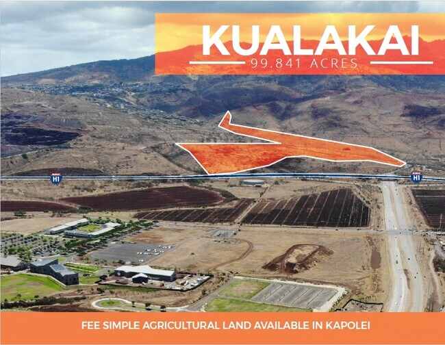
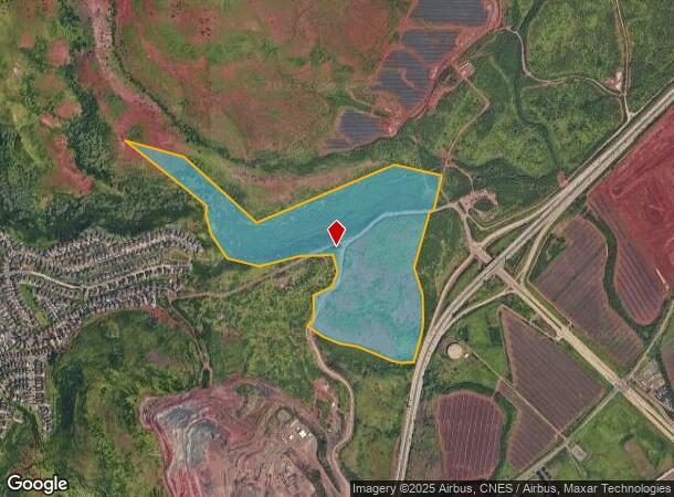
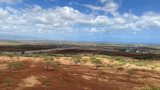
Kunia Rd, Kapolei, HI 96707
NEARBY LISTINGS FOR SALE OR LEASE
Property Detail
Kunia Rd
Urban Honolulu, HI
LOT 19753 99.841 AC MAP 1622 LCAPP 1069
1-9-2-002-008-0000
Honolulu
Agriculturalland
Hawaii
D
19753
15003C0310G
99.84 AC
2024
West Oahu
2025
Hawaii
008632
DEMOGRAPHICS near Kunia Rd
1 Mile
3 Mile
5 Mile
2024 Total Population
481
70,373
142,109
2029 Population
448
67,667
135,632
Pop Growth 2024-2029
(6.86%)
(3.85%)
(4.56%)
Average Age
36
37
38
2024 Total Households
131
20,208
39,451
HH Growth 2024-2029
(7.63%)
(4.36%)
(5.16%)
Median Household Inc
$148,295
$109,784
$109,038
Avg Household Size
3.40
3.30
3.40
2024 Avg HH Vehicles
3.00
2.00
2.00
Median Home Value
$807,432
$716,132
$719,872
Median Year Built
2002
1996
1996
Nearby Places
Map Layers
Map Styles
 Street
 Aerial
- Restaurants
- Banks
- Shops
- Fitness
- Groceries
PUBLIC TRANSPORTATION
AIRPORT
Daniel K Inouye International
DRIVE
WALK
Distance
Daniel K Inouye International
23 min
14.5 mi
Freight Ports
Honolulu Harbor, Oahu
DRIVE
WALK
Distance
Honolulu Harbor, Oahu
31 min
18.7 mi
SALE & LEASE HISTORY
LISTING DATE
SALE/LEASE

Nov 13, 2020
For Sale
Nov 10, 2020
For Sale
Nearby Properties
Address
Land Use
TOTAL SIZE
Lot Size
Zoning
Address
Land Use
TOTAL SIZE
Lot Size
Zoning
310,432 SF
192.56 AC
BMX-3
Address
Land Use
TOTAL SIZE
Lot Size
Zoning
645,869 SF
48.95 AC
AG-1
Address
Land Use
TOTAL SIZE
Lot Size
Zoning
82,948 SF
16.06 AC
AG-1
Address
Land Use
TOTAL SIZE
Lot Size
Zoning
229,396 SF
11.31 AC
BMX-3
Address
Land Use
TOTAL SIZE
Lot Size
Zoning
2,225 SF
19.72 AC
AG-1
Address
Land Use
TOTAL SIZE
Lot Size
Zoning
46.69 AC
BMX-3
Address
Land Use
TOTAL SIZE
Lot Size
Zoning
222,228 SF
7.15 AC
B-2
Address
Land Use
TOTAL SIZE
Lot Size
Zoning
149,923 SF
13.35 AC
BMX-3
Address
Land Use
TOTAL SIZE
Lot Size
Zoning
158,113 SF
21.79 AC
B-2
Address
Land Use
TOTAL SIZE
Lot Size
Zoning
1,714 SF
200.33 AC
AG-1
Address
Land Use
TOTAL SIZE
Lot Size
Zoning
63,936 SF
62.24 AC
F-1
Address
Land Use
TOTAL SIZE
Lot Size
Zoning
208,386 SF
2.84 AC
B-2
Address
Land Use
TOTAL SIZE
Lot Size
Zoning
139,755 SF
18.79 AC
B-2
Address
Land Use
TOTAL SIZE
Lot Size
Zoning
13.47 AC
AMX-2
Address
Land Use
TOTAL SIZE
Lot Size
Zoning
38.08 AC
A/51/50
Address
Land Use
TOTAL SIZE
Lot Size
Zoning
96,501 SF
12.49 AC
BMX-3
Address
Land Use
TOTAL SIZE
Lot Size
Zoning
424,593 SF
8.73 AC
B-2
Address
Land Use
TOTAL SIZE
Lot Size
Zoning
136,868 SF
2.84 AC
B-2
Address
Land Use
TOTAL SIZE
Lot Size
Zoning
41,964 SF
69.57 AC
F-1
Address
Land Use
TOTAL SIZE
Lot Size
Zoning
158,348 SF
10.28 AC
BMX-3
Address
Land Use
TOTAL SIZE
Lot Size
Zoning
157,460 SF
9.51 AC
BMX-3
Address
Land Use
TOTAL SIZE
Lot Size
Zoning
24,364 SF
B-2
Address
Land Use
TOTAL SIZE
Lot Size
Zoning
106,692 SF
5.02 AC
BMX-3
Address
Land Use
TOTAL SIZE
Lot Size
Zoning
105,618 SF
4.99 AC
BMX-3
Address
Land Use
TOTAL SIZE
Lot Size
Zoning
18,943 SF
B-2
Address
Land Use
TOTAL SIZE
Lot Size
Zoning
352,038 SF
11.52 AC
B-2
Address
Land Use
TOTAL SIZE
Lot Size
Zoning
18,472 SF
22.07 AC
F-1
Address
Land Use
TOTAL SIZE
Lot Size
Zoning
79,561 SF
1.40 AC
BMX-3
Address
Land Use
TOTAL SIZE
Lot Size
Zoning
91,808 SF
6.59 AC
BMX-3
The World's #1 Commercial Real Estate Marketplace
Connect with us
© 2026 CoStar Group
The information above has been obtained from sources believed reliable. While we do not doubt its accuracy we have not verified it and make no guarantee, warranty or representation about it. It is your responsibility to independently confirm its accuracy and completeness. Any projections, opinions, assumptions, or estimates used are for example only and do not represent the current or future performance of the property. The value of this transaction to you depends on tax and other factors which should be evaluated by your tax, financial, and legal advisors. You and your advisors should conduct a careful, independent investigation of the property to determine to your satisfaction the suitability of the property for your needs.