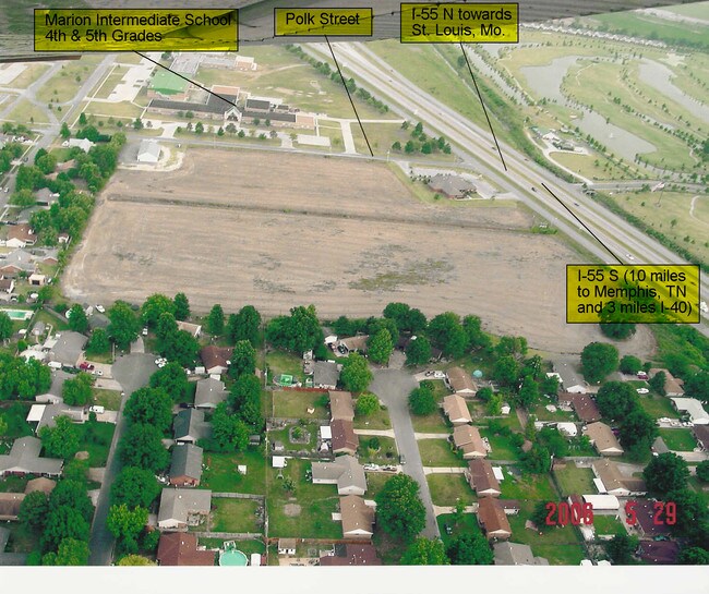
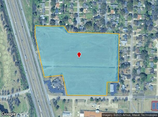
Property Record
L H Polk Dr N I-55 Service Rd, Marion, AR 72364
NEARBY LISTINGS FOR SALE OR LEASE
Property Detail
L H Polk Dr N I-55 Service Rd
Memphis, TN-MS-AR
Baioni Interstate 55 Property
223-800000-000
PB 4 PG 250 REPLAT PB 4 PG 282
Agriculturalland
Crittenden
A
Arkansas
05035C0330E
1
2025
15.62 AC
2025
Crittenden County
030805
Memphis
DEMOGRAPHICS near L H Polk Dr N I-55 Service Rd
1 Mile
3 Mile
5 Mile
2024 Total Population
6,837
18,379
37,408
2029 Population
6,542
17,691
36,330
Pop Growth 2024-2029
(4.31%)
(3.74%)
(2.88%)
Average Age
37
38
38
2024 Total Households
2,631
7,046
14,570
HH Growth 2024-2029
(4.33%)
(3.73%)
(2.89%)
Median Household Inc
$71,570
$66,858
$47,795
Avg Household Size
2.50
2.50
2.50
2024 Avg HH Vehicles
2.00
2.00
2.00
Median Home Value
$157,679
$163,205
$145,642
Median Year Built
1994
1988
1983
Nearby Places
Map Layers
Map Styles
 Street
 Aerial
- Restaurants
- Banks
- Shops
- Fitness
- Groceries
PUBLIC TRANSPORTATION
AIRPORT
Memphis International
DRIVE
WALK
Distance
Memphis International
34 min
20.2 mi
Nearby Properties
Address
Land Use
TOTAL SIZE
Lot Size
Zoning
Address
Land Use
TOTAL SIZE
Lot Size
Zoning
847,384 SF
77.14 AC
Address
Land Use
TOTAL SIZE
Lot Size
Zoning
600,000 SF
36.16 AC
Address
Land Use
TOTAL SIZE
Lot Size
Zoning
5,772 SF
20 AC
Address
Land Use
TOTAL SIZE
Lot Size
Zoning
3,960 SF
14.54 AC
Address
Land Use
TOTAL SIZE
Lot Size
Zoning
46,927 SF
7.52 AC
Address
Land Use
TOTAL SIZE
Lot Size
Zoning
209,064 SF
26.97 AC
Address
Land Use
TOTAL SIZE
Lot Size
Zoning
79,208 SF
3.98 AC
Address
Land Use
TOTAL SIZE
Lot Size
Zoning
72,051 SF
1.98 AC
Address
Land Use
TOTAL SIZE
Lot Size
Zoning
87,608 SF
10.02 AC
Address
Land Use
TOTAL SIZE
Lot Size
Zoning
58,365 SF
6.11 AC
Address
Land Use
TOTAL SIZE
Lot Size
Zoning
28,600 SF
7 AC
Address
Land Use
TOTAL SIZE
Lot Size
Zoning
7,482 SF
7.17 AC
Address
Land Use
TOTAL SIZE
Lot Size
Zoning
59,284 SF
2.06 AC
Address
Land Use
TOTAL SIZE
Lot Size
Zoning
194,110 SF
125.33 AC
Address
Land Use
TOTAL SIZE
Lot Size
Zoning
50,279 SF
2.20 AC
Address
Land Use
TOTAL SIZE
Lot Size
Zoning
10,220 SF
11.74 AC
Address
Land Use
TOTAL SIZE
Lot Size
Zoning
46,035 SF
2.31 AC
Address
Land Use
TOTAL SIZE
Lot Size
Zoning
45,016 SF
1.58 AC
Address
Land Use
TOTAL SIZE
Lot Size
Zoning
46,656 SF
1.39 AC
Address
Land Use
TOTAL SIZE
Lot Size
Zoning
148,342 SF
9.87 AC
Address
Land Use
TOTAL SIZE
Lot Size
Zoning
44,648 SF
5.74 AC
Address
Land Use
TOTAL SIZE
Lot Size
Zoning
43,570 SF
1.80 AC
Address
Land Use
TOTAL SIZE
Lot Size
Zoning
64,791 SF
3.57 AC
Address
Land Use
TOTAL SIZE
Lot Size
Zoning
7,924 SF
7.66 AC
Address
Land Use
TOTAL SIZE
Lot Size
Zoning
52,902 SF
Address
Land Use
TOTAL SIZE
Lot Size
Zoning
12,000 SF
10.35 AC
Address
Land Use
TOTAL SIZE
Lot Size
Zoning
17,814 SF
2 AC
Address
Land Use
TOTAL SIZE
Lot Size
Zoning
85,627 SF
36.79 AC
Address
Land Use
TOTAL SIZE
Lot Size
Zoning
29,340 SF
1.01 AC
Address
Land Use
TOTAL SIZE
Lot Size
Zoning
28,746 SF
3.11 AC
The World's #1 Commercial Real Estate Marketplace
Connect with us
© 2025 CoStar Group
The information above has been obtained from sources believed reliable. While we do not doubt its accuracy we have not verified it and make no guarantee, warranty or representation about it. It is your responsibility to independently confirm its accuracy and completeness. Any projections, opinions, assumptions, or estimates used are for example only and do not represent the current or future performance of the property. The value of this transaction to you depends on tax and other factors which should be evaluated by your tax, financial, and legal advisors. You and your advisors should conduct a careful, independent investigation of the property to determine to your satisfaction the suitability of the property for your needs.