Property Record
L1 Thea Dr, Harrisburg, PA 17110

NEARBY LISTINGS FOR SALE OR LEASE
Property Detail
L1 Thea Dr
62-021-038
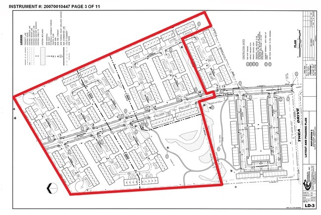
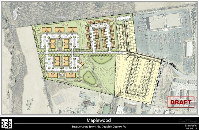
Maplewood Ph 01&1A
Apartmenthouse5plusunits
Dauphin
X
Pennsylvania
42043C0330D
24.77 AC
2025
Harrisburg Area East
2025
Philadelphia
021904
Harrisburg-Carlisle, PA
DEMOGRAPHICS near L1 Thea Dr
1 Mile
3 Mile
5 Mile
2024 Total Population
8,997
48,170
152,002
2029 Population
9,280
49,355
156,135
Pop Growth 2024-2029
+ 3.15%
+ 2.46%
+ 2.72%
Average Age
43
42
40
2024 Total Households
3,902
20,051
63,361
HH Growth 2024-2029
+ 3.10%
+ 2.52%
+ 2.84%
Median Household Inc
$84,415
$79,649
$63,547
Avg Household Size
2.20
2.30
2.30
2024 Avg HH Vehicles
2.00
2.00
2.00
Median Home Value
$233,333
$218,067
$185,737
Median Year Built
1995
1978
1965
Nearby Places
Map Layers
Map Styles
 Street
 Aerial
- Restaurants
- Banks
- Shops
- Fitness
- Groceries
PUBLIC TRANSPORTATION
COMMUTER RAIL
Harrisburg (Keystone Service - Amtrak, Pennsylvanian - Amtrak)
DRIVE
WALK
Distance
Harrisburg (Keystone Service - Amtrak, Pennsylvanian - Amtrak)
14 min
6.4 mi
AIRPORT
Harrisburg International
DRIVE
WALK
Distance
Harrisburg International
23 min
13.7 mi
Freight Ports
Port of Baltimore
DRIVE
WALK
Distance
Port of Baltimore
121 min
86.6 mi
SALE & LEASE HISTORY
LISTING DATE
SALE/LEASE

Aug 03, 2020
For Sale
Nearby Properties
Address
Land Use
TOTAL SIZE
Lot Size
Zoning
Address
Land Use
TOTAL SIZE
Lot Size
Zoning
615,797 SF
59.70 AC
Address
Land Use
TOTAL SIZE
Lot Size
Zoning
3,025 SF
274.13 AC
Address
Land Use
TOTAL SIZE
Lot Size
Zoning
638,721 SF
47.78 AC
Address
Land Use
TOTAL SIZE
Lot Size
Zoning
130,542 SF
28.94 AC
Address
Land Use
TOTAL SIZE
Lot Size
Zoning
125,255 SF
26.65 AC
Address
Land Use
TOTAL SIZE
Lot Size
Zoning
192,390 SF
43.19 AC
Address
Land Use
TOTAL SIZE
Lot Size
Zoning
242,534 SF
47.26 AC
Address
Land Use
TOTAL SIZE
Lot Size
Zoning
2,129 SF
19.90 AC
Address
Land Use
TOTAL SIZE
Lot Size
Zoning
112,388 SF
38.01 AC
Address
Land Use
TOTAL SIZE
Lot Size
Zoning
226,101 SF
46.29 AC
Address
Land Use
TOTAL SIZE
Lot Size
Zoning
82,881 SF
16.90 AC
Address
Land Use
TOTAL SIZE
Lot Size
Zoning
2,823 SF
36.87 AC
Address
Land Use
TOTAL SIZE
Lot Size
Zoning
1,989 SF
16.62 AC
Address
Land Use
TOTAL SIZE
Lot Size
Zoning
139,381 SF
42.61 AC
Address
Land Use
TOTAL SIZE
Lot Size
Zoning
665,098 SF
14 AC
Address
Land Use
TOTAL SIZE
Lot Size
Zoning
Address
Land Use
TOTAL SIZE
Lot Size
Zoning
9.88 AC
Address
Land Use
TOTAL SIZE
Lot Size
Zoning
246,276 SF
27.26 AC
Address
Land Use
TOTAL SIZE
Lot Size
Zoning
880 SF
18.68 AC
Address
Land Use
TOTAL SIZE
Lot Size
Zoning
1,920 SF
38.44 AC
Address
Land Use
TOTAL SIZE
Lot Size
Zoning
114,044 SF
23.13 AC
Address
Land Use
TOTAL SIZE
Lot Size
Zoning
29,125 SF
11.77 AC
Address
Land Use
TOTAL SIZE
Lot Size
Zoning
11,928 SF
8.40 AC
Address
Land Use
TOTAL SIZE
Lot Size
Zoning
66,864 SF
26.25 AC
Address
Land Use
TOTAL SIZE
Lot Size
Zoning
78,525 SF
15.50 AC
Address
Land Use
TOTAL SIZE
Lot Size
Zoning
3,192 SF
17.32 AC
Address
Land Use
TOTAL SIZE
Lot Size
Zoning
21,944 SF
12.40 AC
Address
Land Use
TOTAL SIZE
Lot Size
Zoning
19,558 SF
12.50 AC
Address
Land Use
TOTAL SIZE
Lot Size
Zoning
371,502 SF
29.96 AC
The World's #1 Commercial Real Estate Marketplace
Connect with us
© 2026 CoStar Group
The information above has been obtained from sources believed reliable. While we do not doubt its accuracy we have not verified it and make no guarantee, warranty or representation about it. It is your responsibility to independently confirm its accuracy and completeness. Any projections, opinions, assumptions, or estimates used are for example only and do not represent the current or future performance of the property. The value of this transaction to you depends on tax and other factors which should be evaluated by your tax, financial, and legal advisors. You and your advisors should conduct a careful, independent investigation of the property to determine to your satisfaction the suitability of the property for your needs.