Property Record
L/45Th Vac Corner Ave, Lancaster, CA 93536

Property Detail
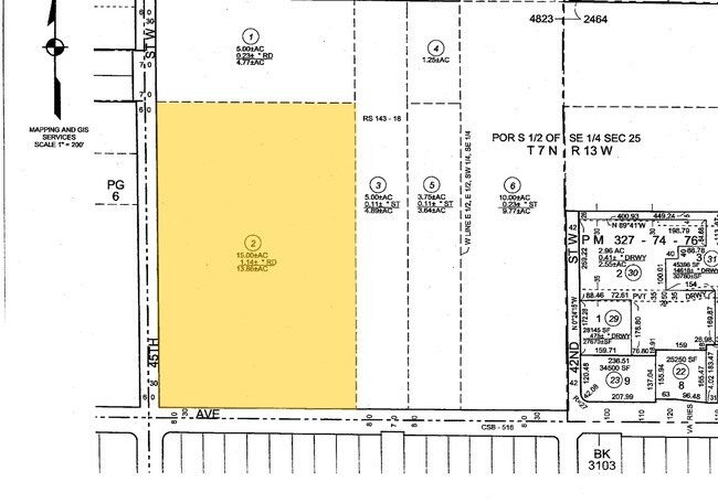
L/45Th Vac Corner Ave
Los Angeles-Long Beach-Glendale, CA
13.86 MORE OR LESS ACS BEING EX OF STS S 1/2 OF NW 1/4 OF SW 1/4 OF SE 1/4 AND SW 1/4 OF SW 1/4 OF SE 1/4 OF SEC 25 T 7N R 13W
3110-007-002
LOS ANGELES
Residentialacreage
California
LCC4-R1100
25
C and X Area of minimal flood hazard, usually depicted on FIRMs as above the 500-year flood level.
13.85 AC
2024
Antelope Valley
2025
Los Angeles
901214
NEARBY LISTINGS FOR SALE OR LEASE
DEMOGRAPHICS near L/45Th Vac Corner Ave
1 mile
3 mile
5 mile
2025 Total Population
8,721
81,900
143,739
2030 Population
8,613
82,058
144,244
Pop Growth 2025-2030
(1.24%)
+ 0.19%
+ 0.35%
Average Age
38
40
39
2025 Total Households
2,845
27,308
48,039
HH Growth 2025-2030
(1.48%)
+ 0.12%
+ 0.40%
Median Household Inc
$88,898
$102,109
$88,829
Avg Household Size
3.00
2.90
2.90
2025 Avg HH Vehicles
2.00
2.00
2.00
Median Home Value
$472,222
$587,109
$530,107
Median Year Built
1980
1990
1988
Nearby Places
Map Layers
Map Styles
 Street
 Aerial
Layers
 Traffic
 Biking
Places
Listings with unknown addresses are not visible on the map
- Restaurants
- Banks
- Shops
- Fitness
- Groceries
PUBLIC TRANSPORTATION
COMMUTER RAIL
Lancaster (Antelope Valley Line - Southern California Regional Rail Authority (Metrolink))
Drive
Walk
Distance
Lancaster (Antelope Valley Line - Southern California Regional Rail Authority (Metrolink))
12 min
6.7 mi
Palmdale (Antelope Valley Line - Southern California Regional Rail Authority (Metrolink))
Drive
Walk
Distance
Palmdale (Antelope Valley Line - Southern California Regional Rail Authority (Metrolink))
15 min
9.8 mi
Nearby Properties
Address
Land Use
TOTAL SIZE
Lot Size
Zoning
Address
Land Use
TOTAL SIZE
Lot Size
Zoning
234,378 SF
15.25 AC
Address
Land Use
TOTAL SIZE
Lot Size
Zoning
153,117 SF
14.12 AC
LRSP80-01*
Address
Land Use
TOTAL SIZE
Lot Size
Zoning
160,028 SF
10.81 AC
LRMDR*
Address
Land Use
TOTAL SIZE
Lot Size
Zoning
179,304 SF
12.43 AC
LRMDR*
Address
Land Use
TOTAL SIZE
Lot Size
Zoning
212,198 SF
18.27 AC
LRSP80-01*
Address
Land Use
TOTAL SIZE
Lot Size
Zoning
129,896 SF
9.10 AC
LRRPD70001
Address
Land Use
TOTAL SIZE
Lot Size
Zoning
60,113 SF
2.03 AC
LRCPD
Address
Land Use
TOTAL SIZE
Lot Size
Zoning
132,584 SF
8.66 AC
LRMDR*
Address
Land Use
TOTAL SIZE
Lot Size
Zoning
170,697 SF
9.29 AC
LRRPD12U*
Address
Land Use
TOTAL SIZE
Lot Size
Zoning
107,924 SF
8.95 AC
LRRPD10000
Address
Land Use
TOTAL SIZE
Lot Size
Zoning
58,043 SF
5.94 AC
PDC3
Address
Land Use
TOTAL SIZE
Lot Size
Zoning
183,296 SF
11.75 AC
LRRPD25U*
Address
Land Use
TOTAL SIZE
Lot Size
Zoning
52,263 SF
1.98 AC
LRCPD*
Address
Land Use
TOTAL SIZE
Lot Size
Zoning
146,468 SF
7.41 AC
LRA22*
Address
Land Use
TOTAL SIZE
Lot Size
Zoning
135,640 SF
6.56 AC
LRRPD75002
Address
Land Use
TOTAL SIZE
Lot Size
Zoning
201,515 SF
4.87 AC
LRCPD*
Address
Land Use
TOTAL SIZE
Lot Size
Zoning
62,739 SF
18.53 AC
LRA22
Address
Land Use
TOTAL SIZE
Lot Size
Zoning
46,328 SF
4.78 AC
LCR1 10000
Address
Land Use
TOTAL SIZE
Lot Size
Zoning
40,014 SF
1.64 AC
LRCPD*
Address
Land Use
TOTAL SIZE
Lot Size
Zoning
71,734 SF
5.93 AC
LRCPD
Address
Land Use
TOTAL SIZE
Lot Size
Zoning
126,813 SF
2.73 AC
LRRA7000*
Address
Land Use
TOTAL SIZE
Lot Size
Zoning
0.34 AC
LCA22*
Address
Land Use
TOTAL SIZE
Lot Size
Zoning
52,924 SF
4.76 AC
LRSP
Address
Land Use
TOTAL SIZE
Lot Size
Zoning
94,491 SF
9.57 AC
LRMDRI
Address
Land Use
TOTAL SIZE
Lot Size
Zoning
165,426 SF
5.03 AC
LRHDR-1
Address
Land Use
TOTAL SIZE
Lot Size
Zoning
53,237 SF
1.69 AC
LRCPD
Address
Land Use
TOTAL SIZE
Lot Size
Zoning
32.02 AC
LRSP
Address
Land Use
TOTAL SIZE
Lot Size
Zoning
39,054 SF
3.92 AC
LRSP
Address
Land Use
TOTAL SIZE
Lot Size
Zoning
47,294 SF
4.45 AC
LRR315U*
Address
Land Use
TOTAL SIZE
Lot Size
Zoning
41,550 SF
6.36 AC
LRRA10000*
The World's #1 Commercial Real Estate Marketplace
Connect with us
© 2026 CoStar Group
The information above has been obtained from sources believed reliable. While we do not doubt its accuracy we have not verified it and make no guarantee, warranty or representation about it. It is your responsibility to independently confirm its accuracy and completeness. Any projections, opinions, assumptions, or estimates used are for example only and do not represent the current or future performance of the property. The value of this transaction to you depends on tax and other factors which should be evaluated by your tax, financial, and legal advisors. You and your advisors should conduct a careful, independent investigation of the property to determine to your satisfaction the suitability of the property for your needs.