Property Record
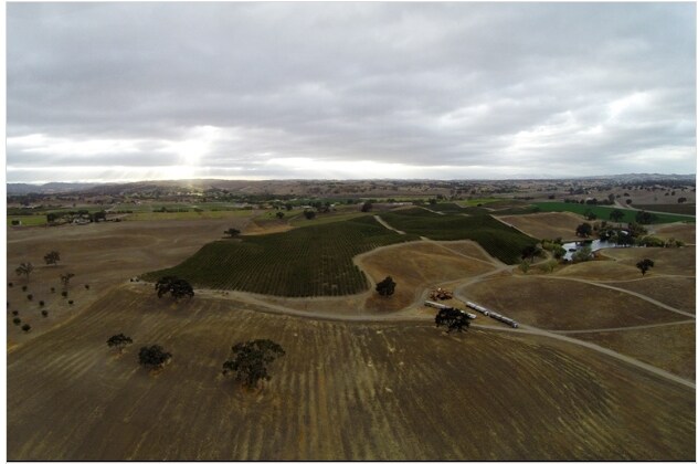
La Panza Rd, Rural El Pomar Estrella, CA 93432
NEARBY LISTINGS FOR SALE OR LEASE
Property Detail
La Panza Rd
San Luis Obispo-Paso Robles-Arroyo Grande, CA
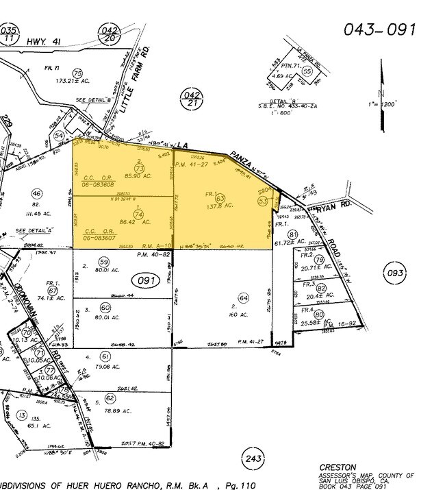
Huer Huero Rho
043-091-074
RHO HR HRO PTN LT 84
Agriculturalland
San Luis Obispo
X
California
06079C0644H
84
2024
86.42 AC
2025
Outlying SLO County
012900
San Luis Obispo/Paso Robles
DEMOGRAPHICS near La Panza Rd
1 Mile
3 Mile
5 Mile
2024 Total Population
28
853
1,542
2029 Population
26
807
1,466
Pop Growth 2024-2029
(7.14%)
(5.39%)
(4.93%)
Average Age
45
44
44
2024 Total Households
11
318
571
HH Growth 2024-2029
(9.09%)
(5.66%)
(5.25%)
Median Household Inc
$93,749
$73,982
$81,174
Avg Household Size
2.50
2.60
2.60
2024 Avg HH Vehicles
3.00
3.00
3.00
Median Home Value
$1,090,000
$1,072,115
$1,049,412
Median Year Built
1997
1992
1991
Nearby Places
Map Layers
Map Styles
 Street
 Aerial
- Restaurants
- Banks
- Shops
- Fitness
- Groceries
PUBLIC TRANSPORTATION
AIRPORT
San Luis County Regional
DRIVE
WALK
Distance
San Luis County Regional
49 min
30.2 mi
Freight Ports
The Port of Hueneme
DRIVE
WALK
Distance
The Port of Hueneme
206 min
157.3 mi
Nearby Properties
Address
Land Use
TOTAL SIZE
Lot Size
Zoning
Address
Land Use
TOTAL SIZE
Lot Size
Zoning
280 AC
AG
Address
Land Use
TOTAL SIZE
Lot Size
Zoning
339.28 AC
AG
Address
Land Use
TOTAL SIZE
Lot Size
Zoning
200 AC
AG
Address
Land Use
TOTAL SIZE
Lot Size
Zoning
Address
Land Use
TOTAL SIZE
Lot Size
Zoning
160 AC
AG
Address
Land Use
TOTAL SIZE
Lot Size
Zoning
1,354 SF
365.10 AC
AG
Address
Land Use
TOTAL SIZE
Lot Size
Zoning
80 AC
AG
Address
Land Use
TOTAL SIZE
Lot Size
Zoning
93.57 AC
AG
Address
Land Use
TOTAL SIZE
Lot Size
Zoning
10.98 AC
RR
Address
Land Use
TOTAL SIZE
Lot Size
Zoning
1,200 SF
210.97 AC
AG
Address
Land Use
TOTAL SIZE
Lot Size
Zoning
31.31 AC
AG
Address
Land Use
TOTAL SIZE
Lot Size
Zoning
86.55 AC
AG
Address
Land Use
TOTAL SIZE
Lot Size
Zoning
Address
Land Use
TOTAL SIZE
Lot Size
Zoning
10.50 AC
AG
Address
Land Use
TOTAL SIZE
Lot Size
Zoning
113.41 AC
AG
Address
Land Use
TOTAL SIZE
Lot Size
Zoning
74.10 AC
AG
Address
Land Use
TOTAL SIZE
Lot Size
Zoning
840 SF
10.06 AC
Address
Land Use
TOTAL SIZE
Lot Size
Zoning
20.08 AC
AG
Address
Land Use
TOTAL SIZE
Lot Size
Zoning
10 AC
RR
Address
Land Use
TOTAL SIZE
Lot Size
Zoning
0.26 AC
RSF
Address
Land Use
TOTAL SIZE
Lot Size
Zoning
121.50 AC
AG
Address
Land Use
TOTAL SIZE
Lot Size
Zoning
1,428 SF
0.43 AC
Address
Land Use
TOTAL SIZE
Lot Size
Zoning
2,890 SF
1.86 AC
CR
Address
Land Use
TOTAL SIZE
Lot Size
Zoning
473.05 AC
REC
Address
Land Use
TOTAL SIZE
Lot Size
Zoning
10 AC
RR
Address
Land Use
TOTAL SIZE
Lot Size
Zoning
3,921 SF
6.31 AC
RR
Address
Land Use
TOTAL SIZE
Lot Size
Zoning
Address
Land Use
TOTAL SIZE
Lot Size
Zoning
90.62 AC
AG
Address
Land Use
TOTAL SIZE
Lot Size
Zoning
102.38 AC
AG
Address
Land Use
TOTAL SIZE
Lot Size
Zoning
11.30 AC
AG
The World's #1 Commercial Real Estate Marketplace
Connect with us
© 2025 CoStar Group
The information above has been obtained from sources believed reliable. While we do not doubt its accuracy we have not verified it and make no guarantee, warranty or representation about it. It is your responsibility to independently confirm its accuracy and completeness. Any projections, opinions, assumptions, or estimates used are for example only and do not represent the current or future performance of the property. The value of this transaction to you depends on tax and other factors which should be evaluated by your tax, financial, and legal advisors. You and your advisors should conduct a careful, independent investigation of the property to determine to your satisfaction the suitability of the property for your needs.