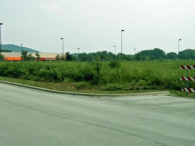
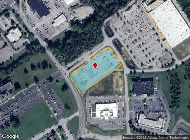
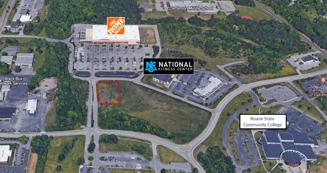
Property Record
185 Laboratory Rd, Oak Ridge, TN 37830

NEARBY LISTINGS FOR SALE OR LEASE
Property Detail
185 Laboratory Rd
Knoxville, TN
A&M Holdings Llc
100B-B-012.00
A&M HOLDINGS LLC PB: 6 PG: 47-D LOT: 586
Commercialnec
Anderson
X
Tennessee
47001C0238F
586
2024
2.62 AC
2025
Anderson County
020202
Knoxville
DEMOGRAPHICS near 185 Laboratory Rd
1 Mile
3 Mile
5 Mile
2024 Total Population
7,102
25,902
39,115
2029 Population
7,576
27,620
41,685
Pop Growth 2024-2029
+ 6.67%
+ 6.63%
+ 6.57%
Average Age
44
41
42
2024 Total Households
3,065
11,252
16,580
HH Growth 2024-2029
+ 6.85%
+ 6.81%
+ 6.71%
Median Household Inc
$71,354
$61,528
$64,464
Avg Household Size
2.20
2.20
2.30
2024 Avg HH Vehicles
2.00
2.00
2.00
Median Home Value
$189,175
$183,928
$192,218
Median Year Built
1968
1962
1967
Nearby Places
Map Layers
Map Styles
 Street
 Aerial
- Restaurants
- Banks
- Shops
- Fitness
- Groceries
PUBLIC TRANSPORTATION
AIRPORT
McGhee Tyson
DRIVE
WALK
Distance
McGhee Tyson
35 min
26.0 mi
Freight Ports
Georgia Ports - Savannah
DRIVE
WALK
Distance
Georgia Ports - Savannah
503 min
434.6 mi
SALE & LEASE HISTORY
LISTING DATE
SALE/LEASE

Jan 17, 2023
For Sale
Aug 10, 2022
For Sale
Nearby Properties
Address
Land Use
TOTAL SIZE
Lot Size
Zoning
Address
Land Use
TOTAL SIZE
Lot Size
Zoning
233,514 SF
10.08 AC
Address
Land Use
TOTAL SIZE
Lot Size
Zoning
413,154 SF
4.10 AC
Address
Land Use
TOTAL SIZE
Lot Size
Zoning
96,668 SF
4.18 AC
Address
Land Use
TOTAL SIZE
Lot Size
Zoning
281,157 SF
31.49 AC
Address
Land Use
TOTAL SIZE
Lot Size
Zoning
248,685 SF
30.42 AC
Address
Land Use
TOTAL SIZE
Lot Size
Zoning
137,652 SF
2.93 AC
Address
Land Use
TOTAL SIZE
Lot Size
Zoning
213,356 SF
10.63 AC
Address
Land Use
TOTAL SIZE
Lot Size
Zoning
112,672 SF
18.21 AC
Address
Land Use
TOTAL SIZE
Lot Size
Zoning
39,628 SF
1.06 AC
Address
Land Use
TOTAL SIZE
Lot Size
Zoning
122,401 SF
16.68 AC
Address
Land Use
TOTAL SIZE
Lot Size
Zoning
120,400 SF
4.57 AC
B2
Address
Land Use
TOTAL SIZE
Lot Size
Zoning
108,723 SF
2.19 AC
Address
Land Use
TOTAL SIZE
Lot Size
Zoning
105,513 SF
4.23 AC
Address
Land Use
TOTAL SIZE
Lot Size
Zoning
147,110 SF
11.17 AC
Address
Land Use
TOTAL SIZE
Lot Size
Zoning
49,574 SF
31.25 AC
Address
Land Use
TOTAL SIZE
Lot Size
Zoning
162,874 SF
12.98 AC
Address
Land Use
TOTAL SIZE
Lot Size
Zoning
190,966 SF
12.70 AC
R3
Address
Land Use
TOTAL SIZE
Lot Size
Zoning
211,501 SF
15.36 AC
Address
Land Use
TOTAL SIZE
Lot Size
Zoning
413,327 SF
73.64 AC
Address
Land Use
TOTAL SIZE
Lot Size
Zoning
67,780 SF
4.40 AC
IND1
Address
Land Use
TOTAL SIZE
Lot Size
Zoning
36,474 SF
1.90 AC
Address
Land Use
TOTAL SIZE
Lot Size
Zoning
86,702 SF
8.20 AC
R3
Address
Land Use
TOTAL SIZE
Lot Size
Zoning
34,905 SF
1.59 AC
OF
Address
Land Use
TOTAL SIZE
Lot Size
Zoning
139,118 SF
10 AC
Address
Land Use
TOTAL SIZE
Lot Size
Zoning
98,832 SF
4.77 AC
Address
Land Use
TOTAL SIZE
Lot Size
Zoning
57,174 SF
6.09 AC
Address
Land Use
TOTAL SIZE
Lot Size
Zoning
74,948 SF
5.07 AC
R7
Address
Land Use
TOTAL SIZE
Lot Size
Zoning
53,109 SF
2.60 AC
Address
Land Use
TOTAL SIZE
Lot Size
Zoning
37,903 SF
6.09 AC
OF
Address
Land Use
TOTAL SIZE
Lot Size
Zoning
32,300 SF
4.17 AC
The World's #1 Commercial Real Estate Marketplace
Connect with us
© 2025 CoStar Group
The information above has been obtained from sources believed reliable. While we do not doubt its accuracy we have not verified it and make no guarantee, warranty or representation about it. It is your responsibility to independently confirm its accuracy and completeness. Any projections, opinions, assumptions, or estimates used are for example only and do not represent the current or future performance of the property. The value of this transaction to you depends on tax and other factors which should be evaluated by your tax, financial, and legal advisors. You and your advisors should conduct a careful, independent investigation of the property to determine to your satisfaction the suitability of the property for your needs.