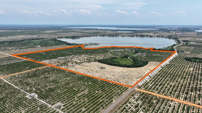
Property Record
Lake Patrick Rd S, Frostproof, FL 33843
Property Detail
Lake Patrick Rd S
Lakeland-Winter Haven, FL
E1/2 OF NE1/4 & E1/4 OF NW1/4 OF NE1/4 & SW1/4 OF NE1/4 FRACTL LESS MAINT R/W
28-31-17-000000-011000
POLK
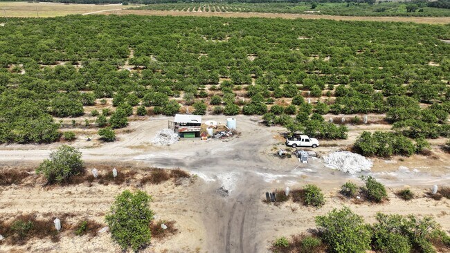
Orchard
Florida
RC
1
AE The base floodplain where base flood elevations are provided. AE Zones are now used on new format FIRMs instead of A1-A30 Zones.
113.77 AC
2024
Polk County
2025
Tampa/St Petersburg
015701
NEARBY LISTINGS FOR SALE OR LEASE
-
-
View all Frostproof listings for sale on LoopNet.com
DEMOGRAPHICS near Lake Patrick Rd S
1 mile
3 mile
5 mile
2025 Total Population
28
4,065
17,922
2030 Population
33
4,734
21,032
Pop Growth 2025-2030
+ 17.86%
+ 16.46%
+ 17.35%
Average Age
39
42
44
2025 Total Households
11
1,639
7,397
HH Growth 2025-2030
+ 18.18%
+ 16.78%
+ 17.89%
Median Household Inc
$93,749
$59,444
$57,715
Avg Household Size
2.50
2.40
2.30
2025 Avg HH Vehicles
2.00
2.00
2.00
Median Home Value
$283,333
$299,999
$183,386
Median Year Built
1977
1978
1985
Nearby Places
Map Layers
Map Styles
 Street
 Aerial
Layers
 Traffic
 Biking
Places
Listings with unknown addresses are not visible on the map
- Restaurants
- Banks
- Shops
- Fitness
- Groceries
SALE & LEASE HISTORY
LISTING DATE
SALE/LEASE

May 16, 2024
For Sale
Nearby Properties
Address
Land Use
TOTAL SIZE
Lot Size
Zoning
Address
Land Use
TOTAL SIZE
Lot Size
Zoning
241,190 SF
36.09 AC
Address
Land Use
TOTAL SIZE
Lot Size
Zoning
113,277 SF
25.01 AC
Address
Land Use
TOTAL SIZE
Lot Size
Zoning
72,646 SF
10.26 AC
Address
Land Use
TOTAL SIZE
Lot Size
Zoning
33,272 SF
3.53 AC
Address
Land Use
TOTAL SIZE
Lot Size
Zoning
11,225 SF
14.04 AC
Address
Land Use
TOTAL SIZE
Lot Size
Zoning
20,293 SF
5.87 AC
Address
Land Use
TOTAL SIZE
Lot Size
Zoning
12,957 SF
3.16 AC
Address
Land Use
TOTAL SIZE
Lot Size
Zoning
11,093 SF
5.25 AC
R2
Address
Land Use
TOTAL SIZE
Lot Size
Zoning
18,716 SF
1.40 AC
Address
Land Use
TOTAL SIZE
Lot Size
Zoning
7,005 SF
13.45 AC
Address
Land Use
TOTAL SIZE
Lot Size
Zoning
8,122 SF
20.96 AC
Address
Land Use
TOTAL SIZE
Lot Size
Zoning
6,786 SF
1.54 AC
Address
Land Use
TOTAL SIZE
Lot Size
Zoning
10,779 SF
1.38 AC
Address
Land Use
TOTAL SIZE
Lot Size
Zoning
27,046 SF
3.21 AC
Address
Land Use
TOTAL SIZE
Lot Size
Zoning
9,156 SF
1.04 AC
GC
Address
Land Use
TOTAL SIZE
Lot Size
Zoning
7,396 SF
1.25 AC
Address
Land Use
TOTAL SIZE
Lot Size
Zoning
13,304 SF
279.98 AC
RC
Address
Land Use
TOTAL SIZE
Lot Size
Zoning
38.76 AC
Address
Land Use
TOTAL SIZE
Lot Size
Zoning
24,400 SF
0.45 AC
CB
Address
Land Use
TOTAL SIZE
Lot Size
Zoning
3,118 SF
1.07 AC
GC
Address
Land Use
TOTAL SIZE
Lot Size
Zoning
7,261 SF
0.73 AC
GC
Address
Land Use
TOTAL SIZE
Lot Size
Zoning
7,122 SF
1.63 AC
Address
Land Use
TOTAL SIZE
Lot Size
Zoning
14,504 SF
0.21 AC
CB
Address
Land Use
TOTAL SIZE
Lot Size
Zoning
6,808 SF
280.87 AC
RC
Address
Land Use
TOTAL SIZE
Lot Size
Zoning
2,134 SF
1.14 AC
RE1
Address
Land Use
TOTAL SIZE
Lot Size
Zoning
2,907 SF
1.40 AC
GC
Address
Land Use
TOTAL SIZE
Lot Size
Zoning
7,816 SF
0.86 AC
Address
Land Use
TOTAL SIZE
Lot Size
Zoning
2,112 SF
0.63 AC
RE1
Address
Land Use
TOTAL SIZE
Lot Size
Zoning
402.86 AC
RC
Address
Land Use
TOTAL SIZE
Lot Size
Zoning
16,966 SF
9.37 AC
GC
The World's #1 Commercial Real Estate Marketplace
Connect with us
© 2026 CoStar Group
The information above has been obtained from sources believed reliable. While we do not doubt its accuracy we have not verified it and make no guarantee, warranty or representation about it. It is your responsibility to independently confirm its accuracy and completeness. Any projections, opinions, assumptions, or estimates used are for example only and do not represent the current or future performance of the property. The value of this transaction to you depends on tax and other factors which should be evaluated by your tax, financial, and legal advisors. You and your advisors should conduct a careful, independent investigation of the property to determine to your satisfaction the suitability of the property for your needs.