Property Record
Lakeview Dr, Arrowbear Lk, CA 92382
Property Detail
Lakeview Dr
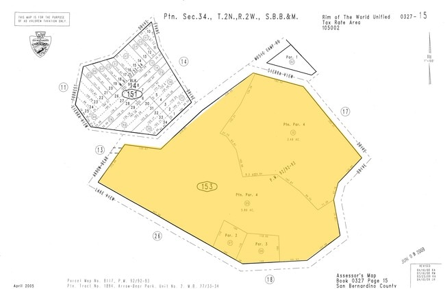
0327-153-10
ALL THAT PORTION OF PARCEL 4 OF PARCEL MAP NO. 8117, IN THE COUNTY OP SAN BERNARDINO, STATE OF CALIFORNIA, AS PER PLAT RECORDED IN BOOK 92 OF PARCEL MAPS, PAGES 92 AND 93, RECORDS OF SAID COUNTY, LYING NORTHEASTERLY OF THE FOLLOWING DESCRIBED LINE: B
Vacantlandnec
SAN BERNARDINO
HTSDRES
California
D Areas with possible but undetermined flood hazards.
3.49 AC
2025
Redlands/Loma Linda
2025
Inland Empire (California)
011101
Riverside-San Bernardino-Ontario, CA
NEARBY LISTINGS FOR SALE OR LEASE
-
-
View all Arrowbear Lk listings for sale on LoopNet.com
DEMOGRAPHICS near Lakeview Dr
1 mile
3 mile
5 mile
2025 Total Population
789
3,789
4,699
2030 Population
765
3,674
4,554
Pop Growth 2025-2030
(3.04%)
(3.04%)
(3.09%)
Average Age
43
43
43
2025 Total Households
352
1,670
2,054
HH Growth 2025-2030
(3.13%)
(2.93%)
(3.02%)
Median Household Inc
$52,059
$82,903
$87,536
Avg Household Size
2.20
2.20
2.30
2025 Avg HH Vehicles
2.00
2.00
2.00
Median Home Value
$371,590
$426,728
$429,351
Median Year Built
1971
1970
1970
Nearby Places
Map Layers
Map Styles
 Street
 Aerial
Layers
 Traffic
 Biking
Places
Listings with unknown addresses are not visible on the map
- Restaurants
- Banks
- Shops
- Fitness
- Groceries
Nearby Properties
Address
Land Use
TOTAL SIZE
Lot Size
Zoning
Address
Land Use
TOTAL SIZE
Lot Size
Zoning
52,483 SF
25 AC
HTSDRES
Address
Land Use
TOTAL SIZE
Lot Size
Zoning
37,780 SF
23.66 AC
Address
Land Use
TOTAL SIZE
Lot Size
Zoning
992 SF
80 AC
HTRC
Address
Land Use
TOTAL SIZE
Lot Size
Zoning
3,534 SF
0.70 AC
HTIC
Address
Land Use
TOTAL SIZE
Lot Size
Zoning
114.72 AC
HTRC
Address
Land Use
TOTAL SIZE
Lot Size
Zoning
2,894 SF
57.84 AC
HTRC
Address
Land Use
TOTAL SIZE
Lot Size
Zoning
9,328 SF
0.40 AC
HTCGSCP
Address
Land Use
TOTAL SIZE
Lot Size
Zoning
4,275 SF
0.36 AC
HTCGSCP
Address
Land Use
TOTAL SIZE
Lot Size
Zoning
19,256 SF
11.06 AC
HTRC
Address
Land Use
TOTAL SIZE
Lot Size
Zoning
4,664 SF
5.88 AC
HTCGSCP
Address
Land Use
TOTAL SIZE
Lot Size
Zoning
18,796 SF
11.88 AC
HTRC
Address
Land Use
TOTAL SIZE
Lot Size
Zoning
5,108 SF
0.21 AC
HTCGSCP
Address
Land Use
TOTAL SIZE
Lot Size
Zoning
7,144 SF
0.75 AC
HTCGSCP
Address
Land Use
TOTAL SIZE
Lot Size
Zoning
5,400 SF
0.59 AC
HTCGSCP
Address
Land Use
TOTAL SIZE
Lot Size
Zoning
126.07 AC
HTSDRES
Address
Land Use
TOTAL SIZE
Lot Size
Zoning
5,483 SF
9.17 AC
HTIC
Address
Land Use
TOTAL SIZE
Lot Size
Zoning
4,307 SF
1.68 AC
HTCGSCP
Address
Land Use
TOTAL SIZE
Lot Size
Zoning
3,029 SF
0.93 AC
HTCGSCP
Address
Land Use
TOTAL SIZE
Lot Size
Zoning
40.25 AC
HTSDRES
Address
Land Use
TOTAL SIZE
Lot Size
Zoning
4,617 SF
0.34 AC
HTCGSCP
Address
Land Use
TOTAL SIZE
Lot Size
Zoning
4,340 SF
0.57 AC
HTCGSCP
Address
Land Use
TOTAL SIZE
Lot Size
Zoning
12,082 SF
0.83 AC
HTCGSCP
Address
Land Use
TOTAL SIZE
Lot Size
Zoning
7,585 SF
2.39 AC
HTCGSCP
Address
Land Use
TOTAL SIZE
Lot Size
Zoning
3,000 SF
1.07 AC
HTIC
Address
Land Use
TOTAL SIZE
Lot Size
Zoning
8.63 AC
HTRC
Address
Land Use
TOTAL SIZE
Lot Size
Zoning
9,075 SF
0.27 AC
HTIC
Address
Land Use
TOTAL SIZE
Lot Size
Zoning
5.84 AC
HTRL5
Address
Land Use
TOTAL SIZE
Lot Size
Zoning
78.26 AC
HTRC
Address
Land Use
TOTAL SIZE
Lot Size
Zoning
5,657 SF
0.49 AC
HTIC
Address
Land Use
TOTAL SIZE
Lot Size
Zoning
8,020 SF
0.15 AC
HTCN
The World's #1 Commercial Real Estate Marketplace
Connect with us
© 2026 CoStar Group
The information above has been obtained from sources believed reliable. While we do not doubt its accuracy we have not verified it and make no guarantee, warranty or representation about it. It is your responsibility to independently confirm its accuracy and completeness. Any projections, opinions, assumptions, or estimates used are for example only and do not represent the current or future performance of the property. The value of this transaction to you depends on tax and other factors which should be evaluated by your tax, financial, and legal advisors. You and your advisors should conduct a careful, independent investigation of the property to determine to your satisfaction the suitability of the property for your needs.