Property Record
Landis Ave, Pilesgrove, NJ 08098

NEARBY LISTINGS FOR SALE OR LEASE
Property Detail
Landis Ave
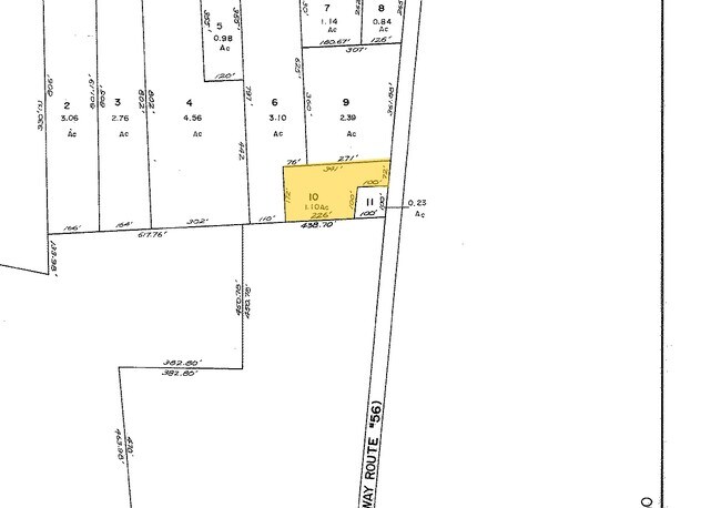
11-02602-0000-00010
Salem
Vacantlandnec
New Jersey
X
10
34011C0176E
1.10 AC
2024
Salem County
2025
Philadelphia
020800
Philadelphia-Camden-Wilmington, PA-NJ-DE-MD
DEMOGRAPHICS near Landis Ave
1 Mile
3 Mile
5 Mile
2024 Total Population
563
8,100
42,018
2029 Population
564
8,001
41,378
Pop Growth 2024-2029
+ 0.18%
(1.22%)
(1.52%)
Average Age
43
41
39
2024 Total Households
199
2,779
14,976
HH Growth 2024-2029
0.00%
(1.30%)
(1.60%)
Median Household Inc
$74,731
$70,963
$57,783
Avg Household Size
2.70
2.80
2.70
2024 Avg HH Vehicles
2.00
2.00
2.00
Median Home Value
$196,874
$190,466
$182,168
Median Year Built
1975
1969
1966
Nearby Places
Map Layers
Map Styles
 Street
 Aerial
- Restaurants
- Banks
- Shops
- Fitness
- Groceries
PUBLIC TRANSPORTATION
AIRPORT
Atlantic City International
DRIVE
WALK
Distance
Atlantic City International
68 min
33.1 mi
Philadelphia International
DRIVE
WALK
Distance
Philadelphia International
60 min
43.2 mi
Freight Ports
Broadway Terminal - Pier 5
DRIVE
WALK
Distance
Broadway Terminal - Pier 5
44 min
34.7 mi
Nearby Properties
Address
Land Use
TOTAL SIZE
Lot Size
Zoning
Address
Land Use
TOTAL SIZE
Lot Size
Zoning
276.61 AC
I4
Address
Land Use
TOTAL SIZE
Lot Size
Zoning
46.22 AC
Address
Land Use
TOTAL SIZE
Lot Size
Zoning
Address
Land Use
TOTAL SIZE
Lot Size
Zoning
173.06 AC
Address
Land Use
TOTAL SIZE
Lot Size
Zoning
29.39 AC
B3
Address
Land Use
TOTAL SIZE
Lot Size
Zoning
26.96 AC
Address
Land Use
TOTAL SIZE
Lot Size
Zoning
26.39 AC
R3
Address
Land Use
TOTAL SIZE
Lot Size
Zoning
16.09 AC
I2
Address
Land Use
TOTAL SIZE
Lot Size
Zoning
11.15 AC
Address
Land Use
TOTAL SIZE
Lot Size
Zoning
11.98 AC
Address
Land Use
TOTAL SIZE
Lot Size
Zoning
16.33 AC
Address
Land Use
TOTAL SIZE
Lot Size
Zoning
3.69 AC
B3
Address
Land Use
TOTAL SIZE
Lot Size
Zoning
Address
Land Use
TOTAL SIZE
Lot Size
Zoning
89.55 AC
R3
Address
Land Use
TOTAL SIZE
Lot Size
Zoning
22.41 AC
Address
Land Use
TOTAL SIZE
Lot Size
Zoning
9.50 AC
Address
Land Use
TOTAL SIZE
Lot Size
Zoning
22.43 AC
I2
Address
Land Use
TOTAL SIZE
Lot Size
Zoning
46,502 SF
12.82 AC
Address
Land Use
TOTAL SIZE
Lot Size
Zoning
14.98 AC
Address
Land Use
TOTAL SIZE
Lot Size
Zoning
5.05 AC
B-4
Address
Land Use
TOTAL SIZE
Lot Size
Zoning
10.75 AC
Address
Land Use
TOTAL SIZE
Lot Size
Zoning
15.42 AC
I2
Address
Land Use
TOTAL SIZE
Lot Size
Zoning
8.50 AC
Address
Land Use
TOTAL SIZE
Lot Size
Zoning
11.04 AC
I2
Address
Land Use
TOTAL SIZE
Lot Size
Zoning
18.23 AC
Address
Land Use
TOTAL SIZE
Lot Size
Zoning
40.90 AC
Address
Land Use
TOTAL SIZE
Lot Size
Zoning
2.92 AC
Address
Land Use
TOTAL SIZE
Lot Size
Zoning
0.27 AC
R3
Address
Land Use
TOTAL SIZE
Lot Size
Zoning
17.30 AC
Address
Land Use
TOTAL SIZE
Lot Size
Zoning
40,034 SF
6 AC
The World's #1 Commercial Real Estate Marketplace
Connect with us
© 2025 CoStar Group
The information above has been obtained from sources believed reliable. While we do not doubt its accuracy we have not verified it and make no guarantee, warranty or representation about it. It is your responsibility to independently confirm its accuracy and completeness. Any projections, opinions, assumptions, or estimates used are for example only and do not represent the current or future performance of the property. The value of this transaction to you depends on tax and other factors which should be evaluated by your tax, financial, and legal advisors. You and your advisors should conduct a careful, independent investigation of the property to determine to your satisfaction the suitability of the property for your needs.