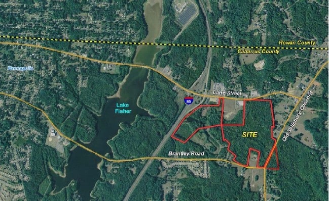
Property Record
Lane St, Kannapolis, NC 28083

Property Detail
Lane St
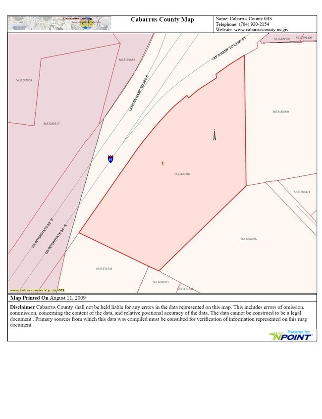
5633-58-0978-0000
P/O TR 1 L K BRANTLEY ESTATE
Gardenaptcourtapt5plusunits
CABARRUS
RC-CZ
North Carolina
B and X Area of moderate flood hazard, usually the area between the limits of the 100-year and 500-year floods.
18.11 AC
2025
Cabarrus County
2025
Charlotte
040705
Charlotte-Concord-Gastonia, NC-SC
NEARBY LISTINGS FOR SALE OR LEASE
-
-
Coldwater Ridge Dr @ Old Earnhardt Rd
Kannapolis, NC 28083
$542,000 - $2,954,270
1.31 - 1.88 AC Lot
Land
-
-
-
-
-
-
View all Kannapolis listings for sale on LoopNet.com
DEMOGRAPHICS near Lane St
1 mile
3 mile
5 mile
2025 Total Population
1,231
20,533
67,347
2030 Population
1,296
21,814
71,722
Pop Growth 2025-2030
+ 5.28%
+ 6.24%
+ 6.50%
Average Age
42
40
40
2025 Total Households
489
7,959
26,559
HH Growth 2025-2030
+ 5.32%
+ 6.41%
+ 6.65%
Median Household Inc
$78,209
$65,490
$62,849
Avg Household Size
2.50
2.50
2.50
2025 Avg HH Vehicles
2.00
2.00
2.00
Median Home Value
$265,999
$236,860
$261,730
Median Year Built
1997
1988
1981
Nearby Places
Map Layers
Map Styles
 Street
 Aerial
Layers
 Traffic
 Biking
Places
Listings with unknown addresses are not visible on the map
- Restaurants
- Banks
- Shops
- Fitness
- Groceries
PUBLIC TRANSPORTATION
COMMUTER RAIL
Kannapolis Station (Piedmont - North Carolina by Train (NC Train))
Drive
Walk
Distance
Kannapolis Station (Piedmont - North Carolina by Train (NC Train))
12 min
4.9 mi
AIRPORT
Concord-Padgett Regional
Drive
Walk
Distance
Concord-Padgett Regional
22 min
14.7 mi
Charlotte/Douglas International
Drive
Walk
Distance
Charlotte/Douglas International
48 min
35.0 mi
Freight Ports
Port of Wilmington
Drive
Walk
Distance
Port of Wilmington
264 min
203.3 mi
Nearby Properties
Address
Land Use
TOTAL SIZE
Lot Size
Zoning
Address
Land Use
TOTAL SIZE
Lot Size
Zoning
728,000 SF
51.80 AC
Address
Land Use
TOTAL SIZE
Lot Size
Zoning
754,000 SF
56.52 AC
I1-CZ
Address
Land Use
TOTAL SIZE
Lot Size
Zoning
297,600 SF
16.28 AC
Address
Land Use
TOTAL SIZE
Lot Size
Zoning
279,000 SF
23.48 AC
Address
Land Use
TOTAL SIZE
Lot Size
Zoning
207,899 SF
21.62 AC
C-2
Address
Land Use
TOTAL SIZE
Lot Size
Zoning
33,728 SF
14.29 AC
GC
Address
Land Use
TOTAL SIZE
Lot Size
Zoning
128,280 SF
10.82 AC
Address
Land Use
TOTAL SIZE
Lot Size
Zoning
68,257 SF
8.26 AC
R8
Address
Land Use
TOTAL SIZE
Lot Size
Zoning
134,363 SF
14.54 AC
C-2
Address
Land Use
TOTAL SIZE
Lot Size
Zoning
50,591 SF
2.41 AC
C-2
Address
Land Use
TOTAL SIZE
Lot Size
Zoning
22,898 SF
10 AC
R18
Address
Land Use
TOTAL SIZE
Lot Size
Zoning
193,301 SF
22.50 AC
C-2
Address
Land Use
TOTAL SIZE
Lot Size
Zoning
50,749 SF
1.85 AC
C-2
Address
Land Use
TOTAL SIZE
Lot Size
Zoning
84,608 SF
23.75 AC
R8
Address
Land Use
TOTAL SIZE
Lot Size
Zoning
96,172 SF
12.27 AC
C-2
Address
Land Use
TOTAL SIZE
Lot Size
Zoning
73,524 SF
8.64 AC
GC
Address
Land Use
TOTAL SIZE
Lot Size
Zoning
23,246 SF
9.76 AC
C-2
Address
Land Use
TOTAL SIZE
Lot Size
Zoning
48,158 SF
1.54 AC
C-2
Address
Land Use
TOTAL SIZE
Lot Size
Zoning
15,141 SF
22.29 AC
R4
Address
Land Use
TOTAL SIZE
Lot Size
Zoning
83,701 SF
2.99 AC
R4
Address
Land Use
TOTAL SIZE
Lot Size
Zoning
2,200 SF
10.81 AC
R4
Address
Land Use
TOTAL SIZE
Lot Size
Zoning
504 SF
196.07 AC
OI
Address
Land Use
TOTAL SIZE
Lot Size
Zoning
37,300 SF
20.95 AC
RM2:MULTI
Address
Land Use
TOTAL SIZE
Lot Size
Zoning
10,216 SF
10.18 AC
C-2
Address
Land Use
TOTAL SIZE
Lot Size
Zoning
29,884 SF
1.87 AC
C-2
Address
Land Use
TOTAL SIZE
Lot Size
Zoning
16,100 SF
4.06 AC
GC
Address
Land Use
TOTAL SIZE
Lot Size
Zoning
8,820 SF
16.83 AC
C-2
Address
Land Use
TOTAL SIZE
Lot Size
Zoning
34,850 SF
8.11 AC
GC
Address
Land Use
TOTAL SIZE
Lot Size
Zoning
72,726 SF
7.14 AC
GC
Address
Land Use
TOTAL SIZE
Lot Size
Zoning
19,718 SF
10.92 AC
R8
The World's #1 Commercial Real Estate Marketplace
Connect with us
© 2026 CoStar Group
The information above has been obtained from sources believed reliable. While we do not doubt its accuracy we have not verified it and make no guarantee, warranty or representation about it. It is your responsibility to independently confirm its accuracy and completeness. Any projections, opinions, assumptions, or estimates used are for example only and do not represent the current or future performance of the property. The value of this transaction to you depends on tax and other factors which should be evaluated by your tax, financial, and legal advisors. You and your advisors should conduct a careful, independent investigation of the property to determine to your satisfaction the suitability of the property for your needs.