Property Record
Laurel Heights Dr Rear Dr, Upper Deerfield, NJ 08302
NEARBY LISTINGS FOR SALE OR LEASE
Property Detail
Laurel Heights Dr Rear Dr
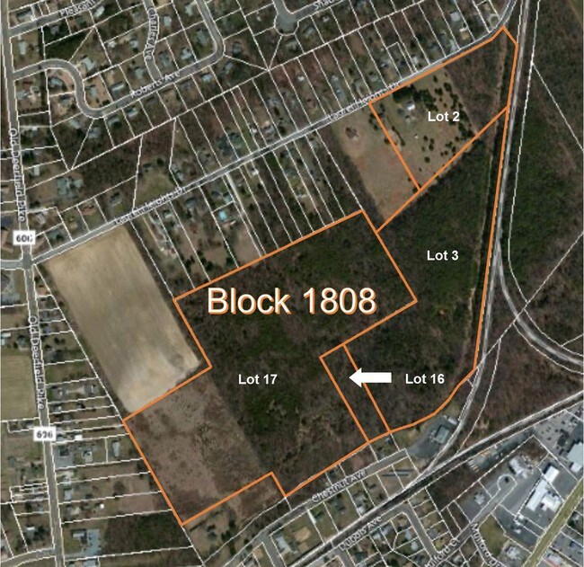
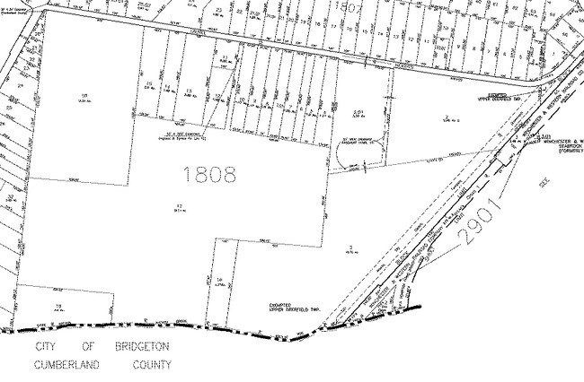
13-01808-0000-00016
Cumberland
Vacantlandnec
New Jersey
X
3
34011C0153E
1.77 AC
2024
Vineland/Bridgeton
2025
Philadelphia
020600
Vineland-Bridgeton, NJ
DEMOGRAPHICS near Laurel Heights Dr Rear Dr
1 Mile
3 Mile
5 Mile
2024 Total Population
2,988
29,939
39,321
2029 Population
2,945
29,434
38,703
Pop Growth 2024-2029
(1.44%)
(1.69%)
(1.57%)
Average Age
39
35
36
2024 Total Households
1,019
9,372
12,795
HH Growth 2024-2029
(1.37%)
(1.70%)
(1.60%)
Median Household Inc
$60,662
$51,472
$54,508
Avg Household Size
2.90
3.00
2.90
2024 Avg HH Vehicles
2.00
2.00
2.00
Median Home Value
$188,906
$178,530
$189,830
Median Year Built
1968
1962
1964
Nearby Places
Map Layers
Map Styles
 Street
 Aerial
- Restaurants
- Banks
- Shops
- Fitness
- Groceries
PUBLIC TRANSPORTATION
AIRPORT
Philadelphia International
DRIVE
WALK
Distance
Philadelphia International
67 min
40.8 mi
Freight Ports
Port of Wilmington, RI
DRIVE
WALK
Distance
Port of Wilmington, RI
48 min
34.2 mi
SALE & LEASE HISTORY
LISTING DATE
SALE/LEASE

Dec 09, 2016
For Sale
Nearby Properties
Address
Land Use
TOTAL SIZE
Lot Size
Zoning
Address
Land Use
TOTAL SIZE
Lot Size
Zoning
83.15 AC
Address
Land Use
TOTAL SIZE
Lot Size
Zoning
140.15 AC
R1
Address
Land Use
TOTAL SIZE
Lot Size
Zoning
3.19 AC
Address
Land Use
TOTAL SIZE
Lot Size
Zoning
52,724 SF
3.32 AC
Address
Land Use
TOTAL SIZE
Lot Size
Zoning
28.60 AC
Address
Land Use
TOTAL SIZE
Lot Size
Zoning
2.71 AC
Address
Land Use
TOTAL SIZE
Lot Size
Zoning
6.20 AC
R1
Address
Land Use
TOTAL SIZE
Lot Size
Zoning
1.73 AC
Address
Land Use
TOTAL SIZE
Lot Size
Zoning
16.23 AC
Address
Land Use
TOTAL SIZE
Lot Size
Zoning
29.17 AC
B2
Address
Land Use
TOTAL SIZE
Lot Size
Zoning
25.91 AC
Address
Land Use
TOTAL SIZE
Lot Size
Zoning
29.38 AC
Address
Land Use
TOTAL SIZE
Lot Size
Zoning
10.70 AC
Address
Land Use
TOTAL SIZE
Lot Size
Zoning
Address
Land Use
TOTAL SIZE
Lot Size
Zoning
13.18 AC
Address
Land Use
TOTAL SIZE
Lot Size
Zoning
12.42 AC
Address
Land Use
TOTAL SIZE
Lot Size
Zoning
22 AC
B2
Address
Land Use
TOTAL SIZE
Lot Size
Zoning
13.67 AC
B2
Address
Land Use
TOTAL SIZE
Lot Size
Zoning
12.95 AC
Address
Land Use
TOTAL SIZE
Lot Size
Zoning
16.54 AC
Address
Land Use
TOTAL SIZE
Lot Size
Zoning
Address
Land Use
TOTAL SIZE
Lot Size
Zoning
97,112 SF
Address
Land Use
TOTAL SIZE
Lot Size
Zoning
Address
Land Use
TOTAL SIZE
Lot Size
Zoning
19.95 AC
Address
Land Use
TOTAL SIZE
Lot Size
Zoning
1.86 AC
Address
Land Use
TOTAL SIZE
Lot Size
Zoning
13.94 AC
Address
Land Use
TOTAL SIZE
Lot Size
Zoning
13.69 AC
Address
Land Use
TOTAL SIZE
Lot Size
Zoning
2.57 AC
Address
Land Use
TOTAL SIZE
Lot Size
Zoning
5.13 AC
Address
Land Use
TOTAL SIZE
Lot Size
Zoning
The World's #1 Commercial Real Estate Marketplace
Connect with us
© 2025 CoStar Group
The information above has been obtained from sources believed reliable. While we do not doubt its accuracy we have not verified it and make no guarantee, warranty or representation about it. It is your responsibility to independently confirm its accuracy and completeness. Any projections, opinions, assumptions, or estimates used are for example only and do not represent the current or future performance of the property. The value of this transaction to you depends on tax and other factors which should be evaluated by your tax, financial, and legal advisors. You and your advisors should conduct a careful, independent investigation of the property to determine to your satisfaction the suitability of the property for your needs.