Property Record
Laurel Vis, , TX
Property Detail
Laurel Vis
160803
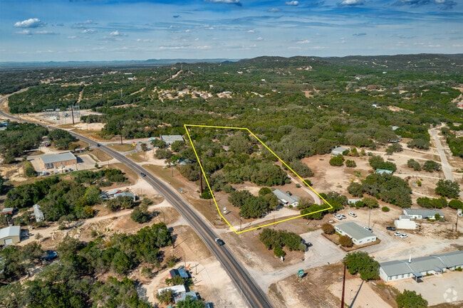
ABST 1075 C BURNHAM SVY 259 TR 7 0.685 ACRES
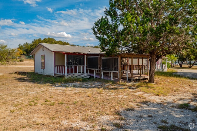
Officebuilding
BANDERA
B and X Area of moderate flood hazard, usually the area between the limits of the 100-year and 500-year floods.
Texas
2025
0.69 AC
2025
Bandera County
000300
San Antonio
1,600 SF
San Antonio-New Braunfels, TX
NEARBY LISTINGS FOR SALE OR LEASE
-
-
View all listings for sale on LoopNet.com
DEMOGRAPHICS near Laurel Vis
1 mile
3 mile
5 mile
2024 Total Population
575
5,476
10,533
2029 Population
616
6,037
11,595
Pop Growth 2024-2029
+ 7.13%
+ 10.24%
+ 10.08%
Average Age
48
47
47
2024 Total Households
231
2,346
4,468
HH Growth 2024-2029
+ 7.36%
+ 10.44%
+ 10.34%
Median Household Inc
$90,151
$82,584
$78,044
Avg Household Size
2.40
2.30
2.30
2024 Avg HH Vehicles
3.00
2.00
2.00
Median Home Value
$388,888
$282,972
$274,379
Median Year Built
2000
1997
1999
Nearby Places
Map Layers
Map Styles
 Street
 Aerial
Transit
 Traffic
 Biking
Places
Listings with unknown addresses are not visible on the map
- Restaurants
- Banks
- Shops
- Fitness
- Groceries
PUBLIC TRANSPORTATION
AIRPORT
San Antonio International
Drive
Walk
Distance
San Antonio International
50 min
35.6 mi
Freight Ports
Port of Corpus Christi
Drive
Walk
Distance
Port of Corpus Christi
191 min
177.7 mi
Nearby Properties
Address
Land Use
TOTAL SIZE
Lot Size
Zoning
Address
Land Use
TOTAL SIZE
Lot Size
Zoning
77,646 SF
10.54 AC
Address
Land Use
TOTAL SIZE
Lot Size
Zoning
8,160 SF
329.42 AC
Address
Land Use
TOTAL SIZE
Lot Size
Zoning
6,705 SF
1.24 AC
Address
Land Use
TOTAL SIZE
Lot Size
Zoning
12,784 SF
2 AC
Address
Land Use
TOTAL SIZE
Lot Size
Zoning
2,128 SF
20.84 AC
Address
Land Use
TOTAL SIZE
Lot Size
Zoning
22,400 SF
3 AC
Address
Land Use
TOTAL SIZE
Lot Size
Zoning
10,260 SF
12.92 AC
Address
Land Use
TOTAL SIZE
Lot Size
Zoning
10,568 SF
8.29 AC
Address
Land Use
TOTAL SIZE
Lot Size
Zoning
3,880 SF
121 AC
Address
Land Use
TOTAL SIZE
Lot Size
Zoning
9,238 SF
1.17 AC
Address
Land Use
TOTAL SIZE
Lot Size
Zoning
9,108 SF
1.36 AC
Address
Land Use
TOTAL SIZE
Lot Size
Zoning
6,416 SF
4.30 AC
Address
Land Use
TOTAL SIZE
Lot Size
Zoning
9,180 SF
1.86 AC
Address
Land Use
TOTAL SIZE
Lot Size
Zoning
4,337 SF
1.13 AC
Address
Land Use
TOTAL SIZE
Lot Size
Zoning
33,715 SF
3.70 AC
Address
Land Use
TOTAL SIZE
Lot Size
Zoning
3,920 SF
2.01 AC
Address
Land Use
TOTAL SIZE
Lot Size
Zoning
1,456 SF
9.48 AC
Address
Land Use
TOTAL SIZE
Lot Size
Zoning
6,503 SF
0.62 AC
Address
Land Use
TOTAL SIZE
Lot Size
Zoning
7,845 SF
1.33 AC
Address
Land Use
TOTAL SIZE
Lot Size
Zoning
2,490 SF
5.36 AC
Address
Land Use
TOTAL SIZE
Lot Size
Zoning
7,386 SF
4.21 AC
Address
Land Use
TOTAL SIZE
Lot Size
Zoning
5,043 SF
4.16 AC
Address
Land Use
TOTAL SIZE
Lot Size
Zoning
2,929 SF
2 AC
Address
Land Use
TOTAL SIZE
Lot Size
Zoning
4,500 SF
1.98 AC
Address
Land Use
TOTAL SIZE
Lot Size
Zoning
5,600 SF
3 AC
Address
Land Use
TOTAL SIZE
Lot Size
Zoning
4,214 SF
0.36 AC
Address
Land Use
TOTAL SIZE
Lot Size
Zoning
2,417 SF
75.37 AC
Address
Land Use
TOTAL SIZE
Lot Size
Zoning
3,886 SF
0.77 AC
Address
Land Use
TOTAL SIZE
Lot Size
Zoning
544 SF
0.60 AC
Address
Land Use
TOTAL SIZE
Lot Size
Zoning
3,767 SF
15 AC
The World's #1 Commercial Real Estate Marketplace
Connect with us
© 2026 CoStar Group
The information above has been obtained from sources believed reliable. While we do not doubt its accuracy we have not verified it and make no guarantee, warranty or representation about it. It is your responsibility to independently confirm its accuracy and completeness. Any projections, opinions, assumptions, or estimates used are for example only and do not represent the current or future performance of the property. The value of this transaction to you depends on tax and other factors which should be evaluated by your tax, financial, and legal advisors. You and your advisors should conduct a careful, independent investigation of the property to determine to your satisfaction the suitability of the property for your needs.