Property Record
Lava Hill Rd, Austin, TX 78744
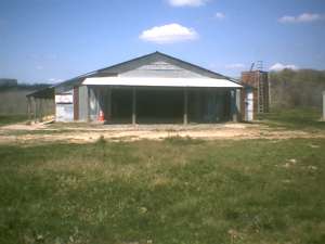

Property Detail
Lava Hill Rd
Austin-Round Rock-San Marcos, TX
LOT 7 *(2.78 ACR) SOUTH ONE HUNDRED EIGHTY THREE PARK
298759
TRAVIS
Warehouse
Texas
B and X Area of moderate flood hazard, usually the area between the limits of the 100-year and 500-year floods.
7
2025
2.78 AC
2025
Southeast
002413
Austin
1,600 SF
NEARBY LISTINGS FOR SALE OR LEASE
DEMOGRAPHICS near Lava Hill Rd
1 mile
3 mile
5 mile
2025 Total Population
3,142
21,131
104,086
2030 Population
3,535
22,944
110,381
Pop Growth 2025-2030
+ 12.51%
+ 8.58%
+ 6.05%
Average Age
36
36
35
2025 Total Households
1,126
7,155
35,861
HH Growth 2025-2030
+ 13.32%
+ 9.70%
+ 6.87%
Median Household Inc
$132,910
$111,182
$80,158
Avg Household Size
2.80
2.90
2.80
2025 Avg HH Vehicles
2.00
2.00
2.00
Median Home Value
$549,208
$458,171
$396,360
Median Year Built
2011
2010
2008
Nearby Places
Map Layers
Map Styles
 Street
 Aerial
Transit
 Traffic
 Biking
Places
Listings with unknown addresses are not visible on the map
- Restaurants
- Banks
- Shops
- Fitness
- Groceries
PUBLIC TRANSPORTATION
AIRPORT
Austin-Bergstrom International
Drive
Walk
Distance
Austin-Bergstrom International
14 min
5.8 mi
Freight Ports
Calhoun Port
Drive
Walk
Distance
Calhoun Port
174 min
145.0 mi
Nearby Properties
Address
Land Use
TOTAL SIZE
Lot Size
Zoning
Address
Land Use
TOTAL SIZE
Lot Size
Zoning
942.08 AC
Address
Land Use
TOTAL SIZE
Lot Size
Zoning
335,913 SF
13.83 AC
Address
Land Use
TOTAL SIZE
Lot Size
Zoning
390,384 SF
34.08 AC
Address
Land Use
TOTAL SIZE
Lot Size
Zoning
287,925 SF
9.92 AC
Address
Land Use
TOTAL SIZE
Lot Size
Zoning
288,174 SF
18.91 AC
Address
Land Use
TOTAL SIZE
Lot Size
Zoning
241,920 SF
23.37 AC
Address
Land Use
TOTAL SIZE
Lot Size
Zoning
326,400 SF
26.12 AC
Address
Land Use
TOTAL SIZE
Lot Size
Zoning
351,255 SF
12.45 AC
Address
Land Use
TOTAL SIZE
Lot Size
Zoning
237,600 SF
17.79 AC
Address
Land Use
TOTAL SIZE
Lot Size
Zoning
249,216 SF
20.19 AC
Address
Land Use
TOTAL SIZE
Lot Size
Zoning
267,300 SF
17.53 AC
Address
Land Use
TOTAL SIZE
Lot Size
Zoning
164,845 SF
33.90 AC
Address
Land Use
TOTAL SIZE
Lot Size
Zoning
181,115 SF
13.81 AC
Address
Land Use
TOTAL SIZE
Lot Size
Zoning
121,950 SF
11.92 AC
Address
Land Use
TOTAL SIZE
Lot Size
Zoning
157,500 SF
10.59 AC
Address
Land Use
TOTAL SIZE
Lot Size
Zoning
162,786 SF
15.43 AC
Address
Land Use
TOTAL SIZE
Lot Size
Zoning
152,817 SF
13.49 AC
Address
Land Use
TOTAL SIZE
Lot Size
Zoning
146,160 SF
8.53 AC
Address
Land Use
TOTAL SIZE
Lot Size
Zoning
407,700 SF
34.50 AC
Address
Land Use
TOTAL SIZE
Lot Size
Zoning
103,061 SF
42.83 AC
Address
Land Use
TOTAL SIZE
Lot Size
Zoning
141,960 SF
24.80 AC
Address
Land Use
TOTAL SIZE
Lot Size
Zoning
131,893 SF
10.01 AC
Address
Land Use
TOTAL SIZE
Lot Size
Zoning
118,018 SF
8.90 AC
Address
Land Use
TOTAL SIZE
Lot Size
Zoning
168,000 SF
11.79 AC
Address
Land Use
TOTAL SIZE
Lot Size
Zoning
56.32 AC
Address
Land Use
TOTAL SIZE
Lot Size
Zoning
96,096 SF
11.39 AC
Address
Land Use
TOTAL SIZE
Lot Size
Zoning
126,000 SF
11.31 AC
Address
Land Use
TOTAL SIZE
Lot Size
Zoning
76,671 SF
44 AC
Address
Land Use
TOTAL SIZE
Lot Size
Zoning
60,606 SF
9.48 AC
Address
Land Use
TOTAL SIZE
Lot Size
Zoning
63,875 SF
4.61 AC
The World's #1 Commercial Real Estate Marketplace
Connect with us
© 2026 CoStar Group
The information above has been obtained from sources believed reliable. While we do not doubt its accuracy we have not verified it and make no guarantee, warranty or representation about it. It is your responsibility to independently confirm its accuracy and completeness. Any projections, opinions, assumptions, or estimates used are for example only and do not represent the current or future performance of the property. The value of this transaction to you depends on tax and other factors which should be evaluated by your tax, financial, and legal advisors. You and your advisors should conduct a careful, independent investigation of the property to determine to your satisfaction the suitability of the property for your needs.