Property Record
Lawson Valley Rd, Alpine, CA 91935
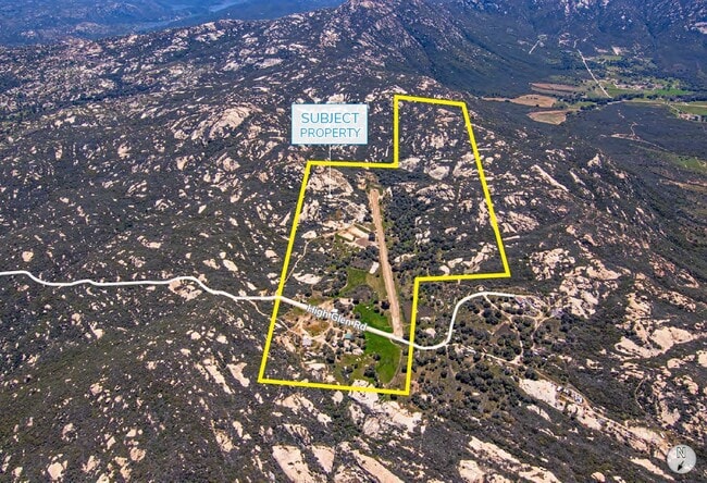
Property Detail
Lawson Valley Rd
522-070-03
SEC 24-16-2E SEQ NEQ OF
Vacantlandnec
SAN DIEGO
A72
California
B and X Area of moderate flood hazard, usually the area between the limits of the 100-year and 500-year floods.
33.82 AC
2024
Outlying SD County S
2025
San Diego
021302
San Diego-Chula Vista-Carlsbad, CA
NEARBY LISTINGS FOR SALE OR LEASE
-
-
View all Alpine listings for sale on LoopNet.com
DEMOGRAPHICS near Lawson Valley Rd
1 mile
3 mile
5 mile
2025 Total Population
92
1,167
5,490
2030 Population
92
1,155
5,460
Pop Growth 2025-2030
0.00%
(1.03%)
(0.55%)
Average Age
45
45
44
2025 Total Households
32
406
1,936
HH Growth 2025-2030
(3.13%)
(1.48%)
(0.83%)
Median Household Inc
$133,333
$134,246
$138,018
Avg Household Size
2.60
2.70
2.80
2025 Avg HH Vehicles
3.00
3.00
3.00
Median Home Value
$680,555
$667,056
$776,577
Median Year Built
1982
1983
1983
Nearby Places
Map Layers
Map Styles
 Street
 Aerial
Layers
 Traffic
 Biking
Places
Listings with unknown addresses are not visible on the map
- Restaurants
- Banks
- Shops
- Fitness
- Groceries
PUBLIC TRANSPORTATION
AIRPORT
San Diego International
Drive
Walk
Distance
San Diego International
64 min
32.8 mi
Freight Ports
Port of San Diego
Drive
Walk
Distance
Port of San Diego
62 min
30.2 mi
SALE & LEASE HISTORY
LISTING DATE
SALE/LEASE

May 07, 2020
For Sale
Feb 11, 2021
For Sale
Apr 04, 2025
For Sale
Nearby Properties
Address
Land Use
TOTAL SIZE
Lot Size
Zoning
Address
Land Use
TOTAL SIZE
Lot Size
Zoning
555.60 AC
S80
Address
Land Use
TOTAL SIZE
Lot Size
Zoning
6,117 SF
76.91 AC
A72
Address
Land Use
TOTAL SIZE
Lot Size
Zoning
2,116 SF
71.35 AC
A72
Address
Land Use
TOTAL SIZE
Lot Size
Zoning
1,932 SF
34.35 AC
A72
Address
Land Use
TOTAL SIZE
Lot Size
Zoning
3,360 SF
14.95 AC
A72
Address
Land Use
TOTAL SIZE
Lot Size
Zoning
2,472 SF
3.68 AC
A72
Address
Land Use
TOTAL SIZE
Lot Size
Zoning
353.37 AC
A72
Address
Land Use
TOTAL SIZE
Lot Size
Zoning
2,915 SF
2.67 AC
A72
Address
Land Use
TOTAL SIZE
Lot Size
Zoning
225.78 AC
A72
Address
Land Use
TOTAL SIZE
Lot Size
Zoning
80.98 AC
A72
Address
Land Use
TOTAL SIZE
Lot Size
Zoning
1,776 SF
6.47 AC
A72
Address
Land Use
TOTAL SIZE
Lot Size
Zoning
4,650 SF
20.22 AC
A72
Address
Land Use
TOTAL SIZE
Lot Size
Zoning
40 AC
A72
Address
Land Use
TOTAL SIZE
Lot Size
Zoning
40 AC
A72
Address
Land Use
TOTAL SIZE
Lot Size
Zoning
2,294 SF
10.96 AC
A72
Address
Land Use
TOTAL SIZE
Lot Size
Zoning
2,959 SF
20 AC
A72
Address
Land Use
TOTAL SIZE
Lot Size
Zoning
11.41 AC
A72
Address
Land Use
TOTAL SIZE
Lot Size
Zoning
40.37 AC
A72
Address
Land Use
TOTAL SIZE
Lot Size
Zoning
80 AC
A72
Address
Land Use
TOTAL SIZE
Lot Size
Zoning
1,973 SF
57.01 AC
A72
Address
Land Use
TOTAL SIZE
Lot Size
Zoning
84.86 AC
A72
Address
Land Use
TOTAL SIZE
Lot Size
Zoning
137 AC
A72
Address
Land Use
TOTAL SIZE
Lot Size
Zoning
38.36 AC
A70
Address
Land Use
TOTAL SIZE
Lot Size
Zoning
150.33 AC
A72
Address
Land Use
TOTAL SIZE
Lot Size
Zoning
179.99 AC
A72
Address
Land Use
TOTAL SIZE
Lot Size
Zoning
40.10 AC
A72
Address
Land Use
TOTAL SIZE
Lot Size
Zoning
8 AC
A72
Address
Land Use
TOTAL SIZE
Lot Size
Zoning
38.23 AC
A72
Address
Land Use
TOTAL SIZE
Lot Size
Zoning
1,384 SF
10 AC
A72
The World's #1 Commercial Real Estate Marketplace
Connect with us
© 2026 CoStar Group
The information above has been obtained from sources believed reliable. While we do not doubt its accuracy we have not verified it and make no guarantee, warranty or representation about it. It is your responsibility to independently confirm its accuracy and completeness. Any projections, opinions, assumptions, or estimates used are for example only and do not represent the current or future performance of the property. The value of this transaction to you depends on tax and other factors which should be evaluated by your tax, financial, and legal advisors. You and your advisors should conduct a careful, independent investigation of the property to determine to your satisfaction the suitability of the property for your needs.