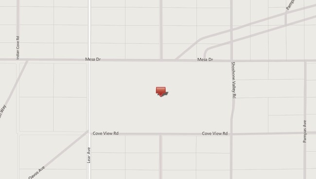
Property Record
4255 Lear Ave, Twentynine Palms, CA 92277

Property Detail
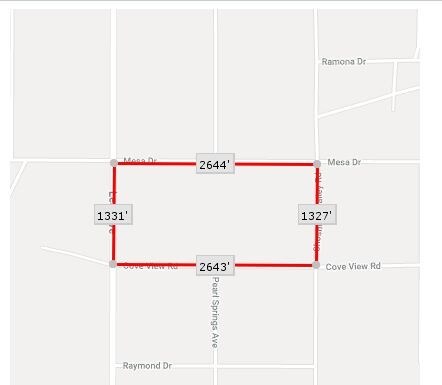
4255 Lear Ave
0612-131-01
N 1/2 NE 1/4 SEC 16 TP 1N R 8E EX MIN RTS
Vacantlandnec
SAN BERNARDINO
RL
California
B and X Area of moderate flood hazard, usually the area between the limits of the 100-year and 500-year floods.
80 AC
2025
Twentynine Palms
2025
Inland Empire (California)
010422
Riverside-San Bernardino-Ontario, CA
NEARBY LISTINGS FOR SALE OR LEASE
DEMOGRAPHICS near 4255 Lear Ave
1 mile
3 mile
5 mile
2025 Total Population
131
1,117
9,236
2030 Population
139
1,176
9,583
Pop Growth 2025-2030
+ 6.11%
+ 5.28%
+ 3.76%
Average Age
47
47
40
2025 Total Households
61
509
3,791
HH Growth 2025-2030
+ 4.92%
+ 5.30%
+ 3.77%
Median Household Inc
$63,500
$63,281
$69,565
Avg Household Size
2.10
2.10
2.40
2025 Avg HH Vehicles
2.00
2.00
2.00
Median Home Value
$226,923
$229,208
$278,703
Median Year Built
1973
1974
1980
Nearby Places
Map Layers
Map Styles
 Street
 Aerial
Layers
 Traffic
 Biking
Places
Listings with unknown addresses are not visible on the map
- Restaurants
- Banks
- Shops
- Fitness
- Groceries
SALE & LEASE HISTORY
LISTING DATE
SALE/LEASE

Sep 24, 2016
For Sale
Nearby Properties
Address
Land Use
TOTAL SIZE
Lot Size
Zoning
Address
Land Use
TOTAL SIZE
Lot Size
Zoning
91.66 AC
Address
Land Use
TOTAL SIZE
Lot Size
Zoning
7,886 SF
6.43 AC
Address
Land Use
TOTAL SIZE
Lot Size
Zoning
2,171 SF
20 AC
Address
Land Use
TOTAL SIZE
Lot Size
Zoning
2,200 SF
0.60 AC
Address
Land Use
TOTAL SIZE
Lot Size
Zoning
18.03 AC
Address
Land Use
TOTAL SIZE
Lot Size
Zoning
316.97 AC
Address
Land Use
TOTAL SIZE
Lot Size
Zoning
160 AC
Address
Land Use
TOTAL SIZE
Lot Size
Zoning
Address
Land Use
TOTAL SIZE
Lot Size
Zoning
73.31 AC
Address
Land Use
TOTAL SIZE
Lot Size
Zoning
5,902 SF
8.89 AC
Address
Land Use
TOTAL SIZE
Lot Size
Zoning
128 AC
RL5
Address
Land Use
TOTAL SIZE
Lot Size
Zoning
Address
Land Use
TOTAL SIZE
Lot Size
Zoning
1,622 SF
0.27 AC
Address
Land Use
TOTAL SIZE
Lot Size
Zoning
19.55 AC
Address
Land Use
TOTAL SIZE
Lot Size
Zoning
Address
Land Use
TOTAL SIZE
Lot Size
Zoning
2,626 SF
0.63 AC
Address
Land Use
TOTAL SIZE
Lot Size
Zoning
38.44 AC
RL5
Address
Land Use
TOTAL SIZE
Lot Size
Zoning
80 AC
Address
Land Use
TOTAL SIZE
Lot Size
Zoning
39.46 AC
RL5
Address
Land Use
TOTAL SIZE
Lot Size
Zoning
40 AC
RL5
Address
Land Use
TOTAL SIZE
Lot Size
Zoning
128 AC
RL5
Address
Land Use
TOTAL SIZE
Lot Size
Zoning
Address
Land Use
TOTAL SIZE
Lot Size
Zoning
1.38 AC
Address
Land Use
TOTAL SIZE
Lot Size
Zoning
20 AC
RL
Address
Land Use
TOTAL SIZE
Lot Size
Zoning
Address
Land Use
TOTAL SIZE
Lot Size
Zoning
16.84 AC
Address
Land Use
TOTAL SIZE
Lot Size
Zoning
8.30 AC
Address
Land Use
TOTAL SIZE
Lot Size
Zoning
18.34 AC
The World's #1 Commercial Real Estate Marketplace
Connect with us
© 2026 CoStar Group
The information above has been obtained from sources believed reliable. While we do not doubt its accuracy we have not verified it and make no guarantee, warranty or representation about it. It is your responsibility to independently confirm its accuracy and completeness. Any projections, opinions, assumptions, or estimates used are for example only and do not represent the current or future performance of the property. The value of this transaction to you depends on tax and other factors which should be evaluated by your tax, financial, and legal advisors. You and your advisors should conduct a careful, independent investigation of the property to determine to your satisfaction the suitability of the property for your needs.