Property Record
Leavenworth Rd, Basehor, KS 66007
NEARBY LISTINGS FOR SALE OR LEASE
-
-
View all Basehor listings for sale on LoopNet.com
Property Detail
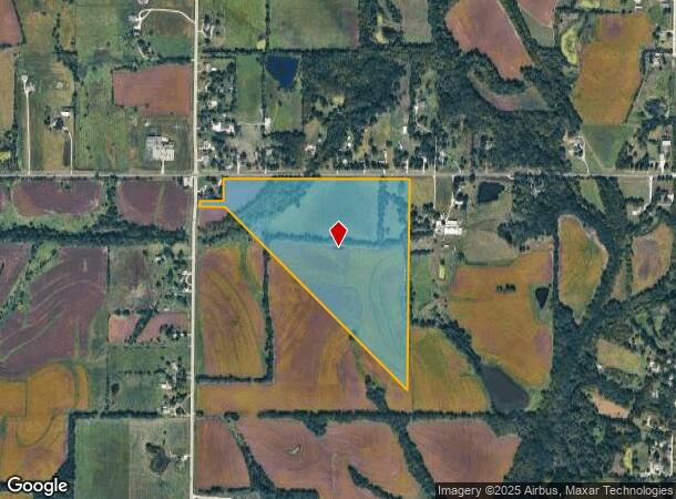
Leavenworth Rd
157-36-0-00-00-008.00-0
S36, T10, R22E, ACRES 61.23, PT NW/14; BEG 281S & 20E NW COR, E290, N241, E2048.56, S2362, NW2822.19, W315.15, N58.5 TO POB
Agriculturalland
Leavenworth
AE
Kansas
20209C0020E
61.23 AC
2023
Leavenworth County
2025
Kansas City
071204
Kansas City, MO-KS
DEMOGRAPHICS near Leavenworth Rd
1 Mile
3 Mile
5 Mile
2024 Total Population
281
11,872
26,405
2029 Population
290
12,000
26,296
Pop Growth 2024-2029
+ 3.20%
+ 1.08%
(0.41%)
Average Age
43
40
40
2024 Total Households
103
4,494
9,870
HH Growth 2024-2029
+ 3.88%
+ 1.02%
(0.47%)
Median Household Inc
$103,125
$101,190
$105,852
Avg Household Size
2.70
2.60
2.60
2024 Avg HH Vehicles
2.00
2.00
2.00
Median Home Value
$334,285
$318,049
$318,504
Median Year Built
1996
2001
2000
Nearby Places
Map Layers
Map Styles
 Street
 Aerial
- Restaurants
- Banks
- Shops
- Fitness
- Groceries
PUBLIC TRANSPORTATION
AIRPORT
Kansas City International
DRIVE
WALK
Distance
Kansas City International
36 min
25.7 mi
Freight Ports
Tulsa Port Of Catoosa
DRIVE
WALK
Distance
Tulsa Port Of Catoosa
277 min
246.9 mi
SALE & LEASE HISTORY
LISTING DATE
SALE/LEASE

Sep 24, 2016
For Sale
Aug 13, 2018
For Sale
Nearby Properties
Address
Land Use
TOTAL SIZE
Lot Size
Zoning
Address
Land Use
TOTAL SIZE
Lot Size
Zoning
134,870 SF
73.61 AC
Address
Land Use
TOTAL SIZE
Lot Size
Zoning
169,410 SF
37.81 AC
Address
Land Use
TOTAL SIZE
Lot Size
Zoning
77,925 SF
11.31 AC
Address
Land Use
TOTAL SIZE
Lot Size
Zoning
52,047 SF
12.18 AC
Address
Land Use
TOTAL SIZE
Lot Size
Zoning
118,146 SF
19.85 AC
WR1B
Address
Land Use
TOTAL SIZE
Lot Size
Zoning
69,406 SF
29.75 AC
Address
Land Use
TOTAL SIZE
Lot Size
Zoning
26,738 SF
82.01 AC
Address
Land Use
TOTAL SIZE
Lot Size
Zoning
24,933 SF
17.16 AC
KAG
Address
Land Use
TOTAL SIZE
Lot Size
Zoning
86,176 SF
49.23 AC
KAG
Address
Land Use
TOTAL SIZE
Lot Size
Zoning
21,511 SF
5.23 AC
Address
Land Use
TOTAL SIZE
Lot Size
Zoning
27,279 SF
17.93 AC
Address
Land Use
TOTAL SIZE
Lot Size
Zoning
39,215 SF
18.35 AC
Address
Land Use
TOTAL SIZE
Lot Size
Zoning
48,590 SF
4.72 AC
Address
Land Use
TOTAL SIZE
Lot Size
Zoning
26,798 SF
9.65 AC
Address
Land Use
TOTAL SIZE
Lot Size
Zoning
2.75 AC
Address
Land Use
TOTAL SIZE
Lot Size
Zoning
27,568 SF
6.57 AC
WR1
Address
Land Use
TOTAL SIZE
Lot Size
Zoning
19,753 SF
4.83 AC
Address
Land Use
TOTAL SIZE
Lot Size
Zoning
16,854 SF
2.60 AC
Address
Land Use
TOTAL SIZE
Lot Size
Zoning
14,834 SF
9.99 AC
Address
Land Use
TOTAL SIZE
Lot Size
Zoning
10,320 SF
38.08 AC
Address
Land Use
TOTAL SIZE
Lot Size
Zoning
12,163 SF
3.31 AC
Address
Land Use
TOTAL SIZE
Lot Size
Zoning
9,100 SF
0.64 AC
Address
Land Use
TOTAL SIZE
Lot Size
Zoning
73.91 AC
Address
Land Use
TOTAL SIZE
Lot Size
Zoning
33,125 SF
5.20 AC
Address
Land Use
TOTAL SIZE
Lot Size
Zoning
5,262 SF
1.94 AC
Address
Land Use
TOTAL SIZE
Lot Size
Zoning
62,774 SF
4.82 AC
Address
Land Use
TOTAL SIZE
Lot Size
Zoning
8,085 SF
3.08 AC
WR
Address
Land Use
TOTAL SIZE
Lot Size
Zoning
13,867 SF
3 AC
Address
Land Use
TOTAL SIZE
Lot Size
Zoning
43,170 SF
6.25 AC
Address
Land Use
TOTAL SIZE
Lot Size
Zoning
17,592 SF
203.39 AC
WAG
The World's #1 Commercial Real Estate Marketplace
Connect with us
© 2025 CoStar Group
The information above has been obtained from sources believed reliable. While we do not doubt its accuracy we have not verified it and make no guarantee, warranty or representation about it. It is your responsibility to independently confirm its accuracy and completeness. Any projections, opinions, assumptions, or estimates used are for example only and do not represent the current or future performance of the property. The value of this transaction to you depends on tax and other factors which should be evaluated by your tax, financial, and legal advisors. You and your advisors should conduct a careful, independent investigation of the property to determine to your satisfaction the suitability of the property for your needs.