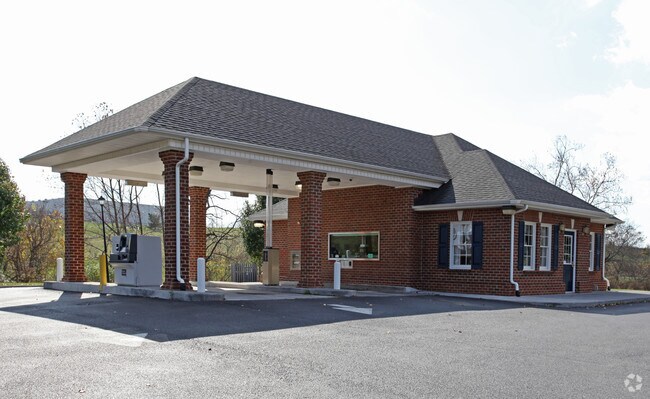
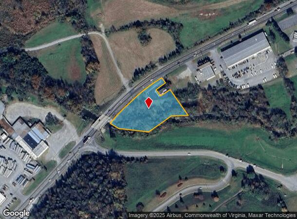
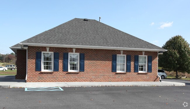
Property Record
Lee Hwy, Roanoke, VA 24019
NEARBY LISTINGS FOR SALE OR LEASE
Property Detail
Lee Hwy
Roanoke, VA
HOLLINS NEW LOT 2A-1C
106B(1)2B2
Botetourt
Commercialacreage
Virginia
AE
2a-1c
51023C0460C
2 AC
2024
Botetourt County
2025
Roanoke
030206
DEMOGRAPHICS near Lee Hwy
1 Mile
3 Mile
5 Mile
2024 Total Population
2,839
21,567
58,372
2029 Population
2,902
21,793
58,499
Pop Growth 2024-2029
+ 2.22%
+ 1.05%
+ 0.22%
Average Age
41
43
42
2024 Total Households
1,078
8,681
24,316
HH Growth 2024-2029
+ 2.32%
+ 1.03%
+ 0.14%
Median Household Inc
$72,018
$70,562
$64,076
Avg Household Size
2.40
2.30
2.30
2024 Avg HH Vehicles
2.00
2.00
2.00
Median Home Value
$295,893
$249,704
$208,962
Median Year Built
1983
1978
1975
Nearby Places
Map Layers
Map Styles
 Street
 Aerial
- Restaurants
- Banks
- Shops
- Fitness
- Groceries
PUBLIC TRANSPORTATION
COMMUTER RAIL
Roanoke (Northeast Regional - Amtrak)
DRIVE
WALK
Distance
Roanoke (Northeast Regional - Amtrak)
13 min
8.3 mi
AIRPORT
Roanoke/Blacksburg Regional (Woodrum Field)
DRIVE
WALK
Distance
Roanoke/Blacksburg Regional (Woodrum Field)
11 min
5.3 mi
Freight Ports
Virginia Port Authority - Richmond
DRIVE
WALK
Distance
Virginia Port Authority - Richmond
208 min
184.4 mi
Nearby Properties
Address
Land Use
TOTAL SIZE
Lot Size
Zoning
Address
Land Use
TOTAL SIZE
Lot Size
Zoning
5,957.14 AC
FC
Address
Land Use
TOTAL SIZE
Lot Size
Zoning
4,284 SF
17.86 AC
R3
Address
Land Use
TOTAL SIZE
Lot Size
Zoning
9.31 AC
B-1
Address
Land Use
TOTAL SIZE
Lot Size
Zoning
609,211 SF
41.01 AC
I1C
Address
Land Use
TOTAL SIZE
Lot Size
Zoning
40.04 AC
M-2
Address
Land Use
TOTAL SIZE
Lot Size
Zoning
15,312 SF
182.27 AC
AG3
Address
Land Use
TOTAL SIZE
Lot Size
Zoning
22.52 AC
R-1
Address
Land Use
TOTAL SIZE
Lot Size
Zoning
124,725 SF
6.53 AC
I1
Address
Land Use
TOTAL SIZE
Lot Size
Zoning
139,654 SF
4.77 AC
C2S
Address
Land Use
TOTAL SIZE
Lot Size
Zoning
36.98 AC
M-1
Address
Land Use
TOTAL SIZE
Lot Size
Zoning
22,950 SF
9.50 AC
R3
Address
Land Use
TOTAL SIZE
Lot Size
Zoning
70,091 SF
11.82 AC
R1
Address
Land Use
TOTAL SIZE
Lot Size
Zoning
35,582 SF
16.36 AC
I2S
Address
Land Use
TOTAL SIZE
Lot Size
Zoning
70,770 SF
6 AC
R3
Address
Land Use
TOTAL SIZE
Lot Size
Zoning
24,512 SF
9.10 AC
C2S
Address
Land Use
TOTAL SIZE
Lot Size
Zoning
35,004 SF
5.07 AC
SCD
Address
Land Use
TOTAL SIZE
Lot Size
Zoning
9.98 AC
A1
Address
Land Use
TOTAL SIZE
Lot Size
Zoning
20,086 SF
9.79 AC
R1S
Address
Land Use
TOTAL SIZE
Lot Size
Zoning
68,179 SF
10.18 AC
C2
Address
Land Use
TOTAL SIZE
Lot Size
Zoning
9.14 AC
M-2
Address
Land Use
TOTAL SIZE
Lot Size
Zoning
58,366 SF
3.02 AC
C2CS
Address
Land Use
TOTAL SIZE
Lot Size
Zoning
14.27 AC
SCD
Address
Land Use
TOTAL SIZE
Lot Size
Zoning
12,252 SF
9.38 AC
R4
Address
Land Use
TOTAL SIZE
Lot Size
Zoning
66,386 SF
8.23 AC
C2CS
Address
Land Use
TOTAL SIZE
Lot Size
Zoning
55,295 SF
4.18 AC
C2
Address
Land Use
TOTAL SIZE
Lot Size
Zoning
113,496 SF
6.51 AC
I1
Address
Land Use
TOTAL SIZE
Lot Size
Zoning
12,152 SF
12.20 AC
R3C
Address
Land Use
TOTAL SIZE
Lot Size
Zoning
28,116 SF
13.48 AC
C2CS
Address
Land Use
TOTAL SIZE
Lot Size
Zoning
9,152 SF
7.75 AC
R3
Address
Land Use
TOTAL SIZE
Lot Size
Zoning
35,056 SF
4.03 AC
C2CS
The World's #1 Commercial Real Estate Marketplace
Connect with us
© 2025 CoStar Group
The information above has been obtained from sources believed reliable. While we do not doubt its accuracy we have not verified it and make no guarantee, warranty or representation about it. It is your responsibility to independently confirm its accuracy and completeness. Any projections, opinions, assumptions, or estimates used are for example only and do not represent the current or future performance of the property. The value of this transaction to you depends on tax and other factors which should be evaluated by your tax, financial, and legal advisors. You and your advisors should conduct a careful, independent investigation of the property to determine to your satisfaction the suitability of the property for your needs.