No Photo
Property Record
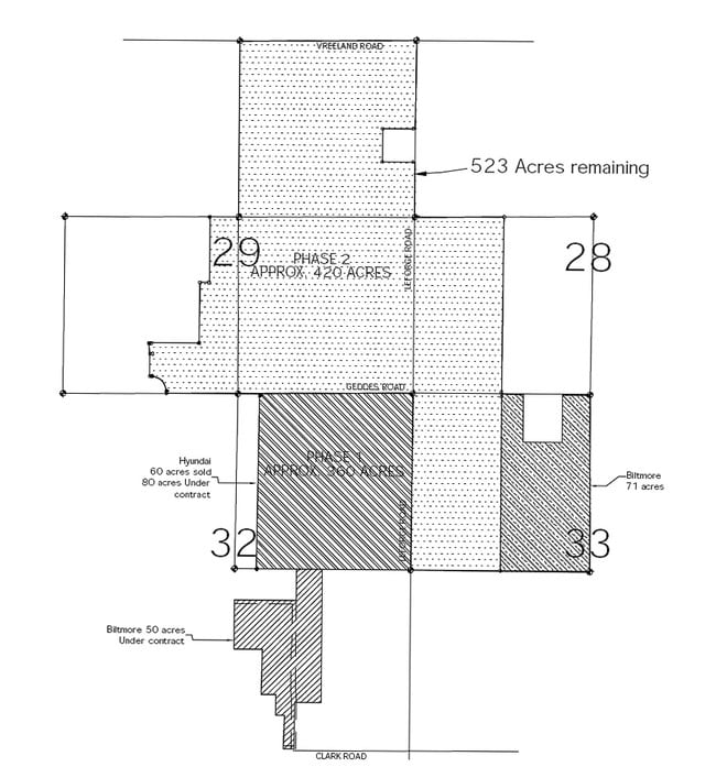
Leforge Rd, Ypsilanti, MI 48198

NEARBY LISTINGS FOR SALE OR LEASE
Property Detail
Leforge Rd
10-29-100-001
OLD SID - J 10-029-001-00 SU 29-1A NE 1/4, EXC SE 1/4 OF NE 1/4 SEC 29, T2S-R7E, 120.00 AC.
Residentialacreage
Washtenaw
X
Michigan
26161C0267E
120 AC
2025
Washtenaw E of 23
2025
Detroit
412000
Ann Arbor, MI
DEMOGRAPHICS near Leforge Rd
1 Mile
3 Mile
5 Mile
2024 Total Population
198
35,316
120,536
2029 Population
196
34,977
119,405
Pop Growth 2024-2029
(1.01%)
(0.96%)
(0.94%)
Average Age
43
36
37
2024 Total Households
66
14,692
50,258
HH Growth 2024-2029
0.00%
(1.05%)
(1.05%)
Median Household Inc
$183,333
$56,284
$59,287
Avg Household Size
2.90
2.10
2.20
2024 Avg HH Vehicles
3.00
2.00
2.00
Median Home Value
$794,117
$245,286
$263,480
Median Year Built
1996
1976
1974
Nearby Places
Map Layers
Map Styles
 Street
 Aerial
- Restaurants
- Banks
- Shops
- Fitness
- Groceries
PUBLIC TRANSPORTATION
COMMUTER RAIL
Ann Arbor Amtrak Station (Wolverine - Amtrak)
DRIVE
WALK
Distance
Ann Arbor Amtrak Station (Wolverine - Amtrak)
17 min
7.1 mi
AIRPORT
Detroit Metro Wayne County
DRIVE
WALK
Distance
Detroit Metro Wayne County
33 min
21.3 mi
Freight Ports
Port of Toledo
DRIVE
WALK
Distance
Port of Toledo
81 min
60.4 mi
SALE & LEASE HISTORY
LISTING DATE
SALE/LEASE

Sep 24, 2016
For Sale
Nearby Properties
Address
Land Use
TOTAL SIZE
Lot Size
Zoning
Address
Land Use
TOTAL SIZE
Lot Size
Zoning
2,668 SF
31.60 AC
PUD
Address
Land Use
TOTAL SIZE
Lot Size
Zoning
169,963 SF
86.24 AC
P-M
Address
Land Use
TOTAL SIZE
Lot Size
Zoning
273,440 SF
73.06 AC
RRA
Address
Land Use
TOTAL SIZE
Lot Size
Zoning
208,890 SF
A-1
Address
Land Use
TOTAL SIZE
Lot Size
Zoning
118,166 SF
P-M
Address
Land Use
TOTAL SIZE
Lot Size
Zoning
361,634 SF
17.09 AC
Address
Land Use
TOTAL SIZE
Lot Size
Zoning
5,416 SF
30.14 AC
R-9
Address
Land Use
TOTAL SIZE
Lot Size
Zoning
340,425 SF
31.50 AC
R4B
Address
Land Use
TOTAL SIZE
Lot Size
Zoning
13,720 SF
37.87 AC
Address
Land Use
TOTAL SIZE
Lot Size
Zoning
480 SF
23.64 AC
BI
Address
Land Use
TOTAL SIZE
Lot Size
Zoning
192,963 SF
21.19 AC
R4A
Address
Land Use
TOTAL SIZE
Lot Size
Zoning
27,306 SF
16.08 AC
BI
Address
Land Use
TOTAL SIZE
Lot Size
Zoning
16,472 SF
29 AC
Address
Land Use
TOTAL SIZE
Lot Size
Zoning
110,389 SF
16.04 AC
RRA
Address
Land Use
TOTAL SIZE
Lot Size
Zoning
Address
Land Use
TOTAL SIZE
Lot Size
Zoning
168,450 SF
8.47 AC
Address
Land Use
TOTAL SIZE
Lot Size
Zoning
122,837 SF
33.40 AC
RRA
Address
Land Use
TOTAL SIZE
Lot Size
Zoning
11,204 SF
28 AC
Address
Land Use
TOTAL SIZE
Lot Size
Zoning
1,020 SF
9.86 AC
R-9
Address
Land Use
TOTAL SIZE
Lot Size
Zoning
27,060 SF
11.47 AC
SPLIT
Address
Land Use
TOTAL SIZE
Lot Size
Zoning
27,060 SF
5.53 AC
SPLIT
Address
Land Use
TOTAL SIZE
Lot Size
Zoning
147,640 SF
32.10 AC
RRA
Address
Land Use
TOTAL SIZE
Lot Size
Zoning
26,550 SF
5.44 AC
MD
Address
Land Use
TOTAL SIZE
Lot Size
Zoning
15,877 SF
60 AC
Address
Land Use
TOTAL SIZE
Lot Size
Zoning
81,279 SF
24.86 AC
PUD
Address
Land Use
TOTAL SIZE
Lot Size
Zoning
54,702 SF
A-1
Address
Land Use
TOTAL SIZE
Lot Size
Zoning
960 SF
15 AC
BA
Address
Land Use
TOTAL SIZE
Lot Size
Zoning
148,651 SF
27.36 AC
RRA
Address
Land Use
TOTAL SIZE
Lot Size
Zoning
29,502 SF
11.29 AC
BA
Address
Land Use
TOTAL SIZE
Lot Size
Zoning
124,513 SF
3.79 AC
GC
The World's #1 Commercial Real Estate Marketplace
Connect with us
© 2025 CoStar Group
The information above has been obtained from sources believed reliable. While we do not doubt its accuracy we have not verified it and make no guarantee, warranty or representation about it. It is your responsibility to independently confirm its accuracy and completeness. Any projections, opinions, assumptions, or estimates used are for example only and do not represent the current or future performance of the property. The value of this transaction to you depends on tax and other factors which should be evaluated by your tax, financial, and legal advisors. You and your advisors should conduct a careful, independent investigation of the property to determine to your satisfaction the suitability of the property for your needs.