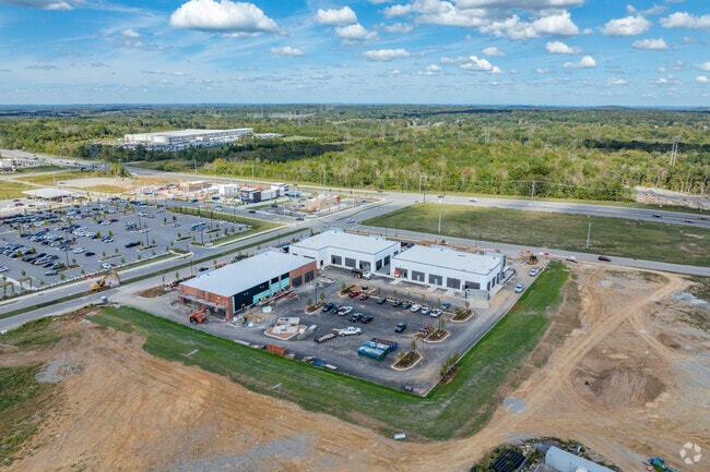
Property Record
105 Rutland Dr, Mount Juliet, TN 37122


Current Lease Availabilities
General Retail LEASE
$42.00 SF/YR
1,000 - 10,000 SF
NEARBY LISTINGS FOR SALE OR LEASE
-
-
-
Legacy Pointe Boulevard @ Rutland Drive
Mount Juliet, TN 37122
$42.00 SF/YR
1,000 - 10,000 SF
Retail
-
-
View all Mount Juliet listings for lease on LoopNet.com
Property Detail
105 Rutland Dr
Nashville
Lois Duke
Nashville-Davidson--Murfreesboro--Franklin, TN
Wilson
095078 01314
Tennessee
Farms
44.95 AC
2024
Mt Juliet-Lebanon
2024
DEMOGRAPHICS near 105 Rutland Dr
1 Mile
3 Mile
5 Mile
2024 Total Population
1,181
19,591
53,631
2029 Population
1,372
23,192
63,666
Pop Growth 2024-2029
+ 16.17%
+ 18.38%
+ 18.71%
Average Age
38
40
39
2024 Total Households
450
7,849
20,125
HH Growth 2024-2029
+ 15.78%
+ 18.09%
+ 18.57%
Median Household Inc
$105,580
$92,079
$98,541
Avg Household Size
2.60
2.50
2.60
2024 Avg HH Vehicles
2.00
2.00
2.00
Median Home Value
$204,192
$438,346
$408,394
Median Year Built
1980
2009
2008
Nearby Places
- Restaurants
- Banks
- Shops
- Fitness
- Groceries
PUBLIC TRANSPORTATION
COMMUTER RAIL
Mt Juliet (East Corridor Line - Tennessee Regional Transportation Authority Music City Star (Music City Star))
DRIVE
WALK
Distance
Mt Juliet (East Corridor Line - Tennessee Regional Transportation Authority Music City Star (Music City Star))
9 min
3.8 mi
Martha (East Corridor Line - Tennessee Regional Transportation Authority Music City Star (Music City Star))
DRIVE
WALK
Distance
Martha (East Corridor Line - Tennessee Regional Transportation Authority Music City Star (Music City Star))
11 min
7.8 mi
AIRPORT
Nashville International
DRIVE
WALK
Distance
Nashville International
20 min
15.7 mi
Freight Ports
Port of Mobile
DRIVE
WALK
Distance
Port of Mobile
504 min
462.5 mi
Nearby Properties
Address
Land Use
TOTAL SIZE
Lot Size
Zoning
Address
Land Use
TOTAL SIZE
Lot Size
Zoning
1,493,463 SF
54.91 AC
Address
Land Use
TOTAL SIZE
Lot Size
Zoning
1,089,622 SF
81.95 AC
Address
Land Use
TOTAL SIZE
Lot Size
Zoning
611,467 SF
88.97 AC
Address
Land Use
TOTAL SIZE
Lot Size
Zoning
105,709 SF
11.38 AC
Address
Land Use
TOTAL SIZE
Lot Size
Zoning
197,114 SF
7.01 AC
Address
Land Use
TOTAL SIZE
Lot Size
Zoning
258,534 SF
14.15 AC
Address
Land Use
TOTAL SIZE
Lot Size
Zoning
189,300 SF
263 AC
Address
Land Use
TOTAL SIZE
Lot Size
Zoning
308,062 SF
20.55 AC
RM16
Address
Land Use
TOTAL SIZE
Lot Size
Zoning
337,419 SF
22.77 AC
Address
Land Use
TOTAL SIZE
Lot Size
Zoning
553,000 SF
25 AC
M4
Address
Land Use
TOTAL SIZE
Lot Size
Zoning
528,580 SF
25 AC
Address
Land Use
TOTAL SIZE
Lot Size
Zoning
704,800 SF
48.96 AC
Address
Land Use
TOTAL SIZE
Lot Size
Zoning
459,108 SF
41.82 AC
Address
Land Use
TOTAL SIZE
Lot Size
Zoning
307,128 SF
27.93 AC
Address
Land Use
TOTAL SIZE
Lot Size
Zoning
479,936 SF
27.50 AC
IR
Address
Land Use
TOTAL SIZE
Lot Size
Zoning
308,249 SF
63.82 AC
Address
Land Use
TOTAL SIZE
Lot Size
Zoning
24,495 SF
29.35 AC
RS10
Address
Land Use
TOTAL SIZE
Lot Size
Zoning
405,450 SF
21.26 AC
M4
Address
Land Use
TOTAL SIZE
Lot Size
Zoning
405,450 SF
20.17 AC
M4
Address
Land Use
TOTAL SIZE
Lot Size
Zoning
240,415 SF
16.52 AC
Address
Land Use
TOTAL SIZE
Lot Size
Zoning
248,088 SF
17.60 AC
Address
Land Use
TOTAL SIZE
Lot Size
Zoning
265,558 SF
16.23 AC
Address
Land Use
TOTAL SIZE
Lot Size
Zoning
74,436 SF
2.09 AC
Address
Land Use
TOTAL SIZE
Lot Size
Zoning
95,840 SF
2.78 AC
CMU
Address
Land Use
TOTAL SIZE
Lot Size
Zoning
300,570 SF
16.73 AC
Address
Land Use
TOTAL SIZE
Lot Size
Zoning
217,422 SF
13.40 AC
M4
Address
Land Use
TOTAL SIZE
Lot Size
Zoning
63,995 SF
2.57 AC
Address
Land Use
TOTAL SIZE
Lot Size
Zoning
66,043 SF
15 AC
Address
Land Use
TOTAL SIZE
Lot Size
Zoning
131,429 SF
12 AC
Address
Land Use
TOTAL SIZE
Lot Size
Zoning
45,300 SF
5.46 AC
The World's #1 Commercial Real Estate Marketplace
Connect with us
© 2025 CoStar Group
The information above has been obtained from sources believed reliable. While we do not doubt its accuracy we have not verified it and make no guarantee, warranty or representation about it. It is your responsibility to independently confirm its accuracy and completeness. Any projections, opinions, assumptions, or estimates used are for example only and do not represent the current or future performance of the property. The value of this transaction to you depends on tax and other factors which should be evaluated by your tax, financial, and legal advisors. You and your advisors should conduct a careful, independent investigation of the property to determine to your satisfaction the suitability of the property for your needs.