Property Record
Mcleod St, Hot Springs, AR 71913

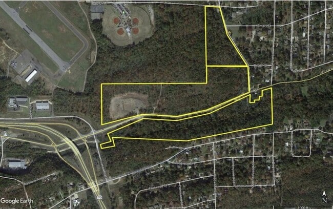
Property Detail
Mcleod St
Hot Springs, AR
PT SW NE, PT N1/2 SW & PT NW SE
300-07914-000
GARLAND
Agriculturalland
Arkansas
AE The base floodplain where base flood elevations are provided. AE Zones are now used on new format FIRMs instead of A1-A30 Zones.
51.52 AC
2025
Arkansas South Area
2025
Other Market Areas
011802
NEARBY LISTINGS FOR SALE OR LEASE
DEMOGRAPHICS near Mcleod St
1 mile
3 mile
5 mile
2025 Total Population
2,103
30,353
59,434
2030 Population
2,046
30,426
59,517
Pop Growth 2025-2030
(2.71%)
+ 0.24%
+ 0.14%
Average Age
47
45
44
2025 Total Households
962
13,986
26,006
HH Growth 2025-2030
(2.81%)
+ 0.24%
+ 0.12%
Median Household Inc
$51,647
$44,017
$48,258
Avg Household Size
2.10
2.10
2.20
2025 Avg HH Vehicles
2.00
2.00
2.00
Median Home Value
$224,827
$203,398
$223,112
Median Year Built
1976
1974
1977
Nearby Places
Map Layers
Map Styles
 Street
 Aerial
Layers
 Traffic
 Biking
Places
Listings with unknown addresses are not visible on the map
- Restaurants
- Banks
- Shops
- Fitness
- Groceries
Nearby Properties
Address
Land Use
TOTAL SIZE
Lot Size
Zoning
Address
Land Use
TOTAL SIZE
Lot Size
Zoning
404,996 SF
131.86 AC
Address
Land Use
TOTAL SIZE
Lot Size
Zoning
167,811 SF
12.88 AC
Address
Land Use
TOTAL SIZE
Lot Size
Zoning
67,373 SF
25.17 AC
Address
Land Use
TOTAL SIZE
Lot Size
Zoning
30,166 SF
18.45 AC
Address
Land Use
TOTAL SIZE
Lot Size
Zoning
223,936 SF
40.74 AC
Address
Land Use
TOTAL SIZE
Lot Size
Zoning
59,966 SF
15.96 AC
Address
Land Use
TOTAL SIZE
Lot Size
Zoning
60,712 SF
7.82 AC
Address
Land Use
TOTAL SIZE
Lot Size
Zoning
212,144 SF
14.42 AC
Address
Land Use
TOTAL SIZE
Lot Size
Zoning
99,432 SF
4.55 AC
Address
Land Use
TOTAL SIZE
Lot Size
Zoning
Address
Land Use
TOTAL SIZE
Lot Size
Zoning
116,678 SF
6.72 AC
Address
Land Use
TOTAL SIZE
Lot Size
Zoning
138,412 SF
13.27 AC
Address
Land Use
TOTAL SIZE
Lot Size
Zoning
25,754 SF
7.87 AC
Address
Land Use
TOTAL SIZE
Lot Size
Zoning
25,473 SF
4.44 AC
Address
Land Use
TOTAL SIZE
Lot Size
Zoning
133,818 SF
13.69 AC
Address
Land Use
TOTAL SIZE
Lot Size
Zoning
199,618 SF
8.79 AC
Address
Land Use
TOTAL SIZE
Lot Size
Zoning
133,720 SF
12.74 AC
Address
Land Use
TOTAL SIZE
Lot Size
Zoning
52,458 SF
2.68 AC
Address
Land Use
TOTAL SIZE
Lot Size
Zoning
Address
Land Use
TOTAL SIZE
Lot Size
Zoning
105,742 SF
6 AC
Address
Land Use
TOTAL SIZE
Lot Size
Zoning
40,332 SF
5.07 AC
Address
Land Use
TOTAL SIZE
Lot Size
Zoning
51,493 SF
9.14 AC
Address
Land Use
TOTAL SIZE
Lot Size
Zoning
68,470 SF
11.54 AC
Address
Land Use
TOTAL SIZE
Lot Size
Zoning
27,512 SF
16.06 AC
Address
Land Use
TOTAL SIZE
Lot Size
Zoning
61,926 SF
4.66 AC
Address
Land Use
TOTAL SIZE
Lot Size
Zoning
103,680 SF
5.02 AC
Address
Land Use
TOTAL SIZE
Lot Size
Zoning
17,985 SF
1.94 AC
Address
Land Use
TOTAL SIZE
Lot Size
Zoning
55,076 SF
2.27 AC
Address
Land Use
TOTAL SIZE
Lot Size
Zoning
42,144 SF
4.98 AC
Address
Land Use
TOTAL SIZE
Lot Size
Zoning
552 SF
100.22 AC
The World's #1 Commercial Real Estate Marketplace
Connect with us
© 2026 CoStar Group
The information above has been obtained from sources believed reliable. While we do not doubt its accuracy we have not verified it and make no guarantee, warranty or representation about it. It is your responsibility to independently confirm its accuracy and completeness. Any projections, opinions, assumptions, or estimates used are for example only and do not represent the current or future performance of the property. The value of this transaction to you depends on tax and other factors which should be evaluated by your tax, financial, and legal advisors. You and your advisors should conduct a careful, independent investigation of the property to determine to your satisfaction the suitability of the property for your needs.