Property Record
Liberty Rd, , MD
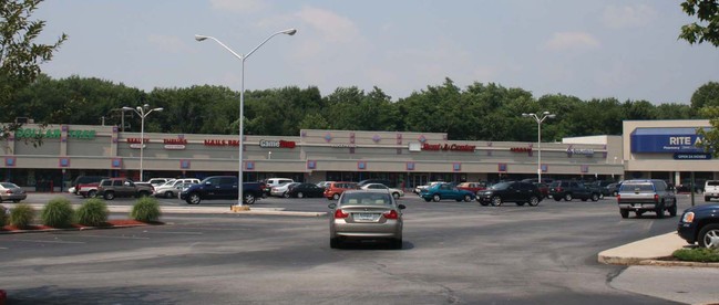

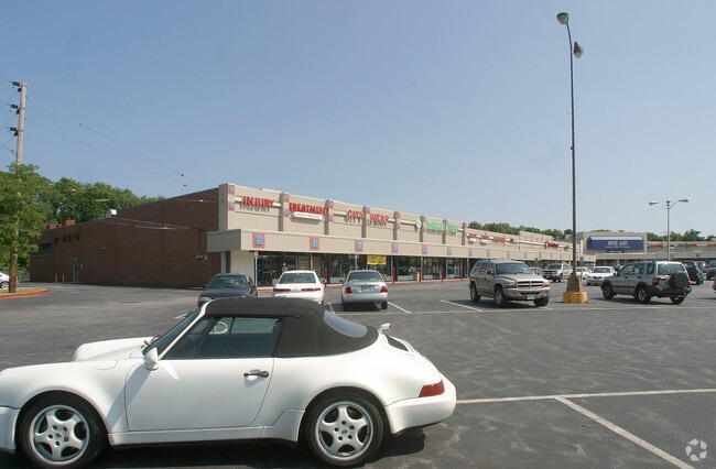
Property Detail
Liberty Rd
02-2000008962
11.1554 AC NES
Regionalshoppingcenterormallwithanchorstore
Baltimore
X
Maryland
24013C0450D
11.16 AC
2024
Reisterstown Rd Corridor
2025
Baltimore
402506
Baltimore-Columbia-Towson, MD
86,600 SF
NEARBY LISTINGS FOR SALE OR LEASE
-
-
-
-
-
No Photo
-
-
-
View all listings for lease on LoopNet.com
DEMOGRAPHICS near Liberty Rd
1 mile
3 mile
5 mile
2024 Total Population
16,499
96,628
211,314
2029 Population
16,135
95,321
207,592
Pop Growth 2024-2029
(2.21%)
(1.35%)
(1.76%)
Average Age
42
41
41
2024 Total Households
6,175
38,055
82,603
HH Growth 2024-2029
(2.30%)
(1.41%)
(1.88%)
Median Household Inc
$74,776
$81,416
$78,036
Avg Household Size
2.60
2.50
2.50
2024 Avg HH Vehicles
2.00
2.00
2.00
Median Home Value
$262,346
$271,525
$280,439
Median Year Built
1968
1980
1976
Nearby Places
Map Layers
Map Styles
 Street
 Aerial
Transit
 Traffic
 Biking
Places
Listings with unknown addresses are not visible on the map
- Restaurants
- Banks
- Shops
- Fitness
- Groceries
PUBLIC TRANSPORTATION
AIRPORT
Baltimore/Washington International Thurgood Marshall
Drive
Walk
Distance
Baltimore/Washington International Thurgood Marshall
27 min
16.4 mi
Freight Ports
Port of Baltimore
Drive
Walk
Distance
Port of Baltimore
28 min
16.4 mi
SALE & LEASE HISTORY
LISTING DATE
SALE/LEASE

Sep 25, 2016
For Lease
Nearby Properties
Address
Land Use
TOTAL SIZE
Lot Size
Zoning
Address
Land Use
TOTAL SIZE
Lot Size
Zoning
630,367 SF
470.44 AC
DR1
Address
Land Use
TOTAL SIZE
Lot Size
Zoning
250,000 SF
1.61 AC
BMCT
Address
Land Use
TOTAL SIZE
Lot Size
Zoning
452,042 SF
17.18 AC
RAE2
Address
Land Use
TOTAL SIZE
Lot Size
Zoning
709,328 SF
25.59 AC
OT
Address
Land Use
TOTAL SIZE
Lot Size
Zoning
12 AC
DR10
Address
Land Use
TOTAL SIZE
Lot Size
Zoning
233,082 SF
10.98 AC
Address
Land Use
TOTAL SIZE
Lot Size
Zoning
16.75 AC
MLR02
Address
Land Use
TOTAL SIZE
Lot Size
Zoning
336,539 SF
12.38 AC
DR16
Address
Land Use
TOTAL SIZE
Lot Size
Zoning
Address
Land Use
TOTAL SIZE
Lot Size
Zoning
325,203 SF
6.24 AC
DR5.5
Address
Land Use
TOTAL SIZE
Lot Size
Zoning
16.70 AC
Address
Land Use
TOTAL SIZE
Lot Size
Zoning
16.48 AC
DR16
Address
Land Use
TOTAL SIZE
Lot Size
Zoning
26.88 AC
DR16
Address
Land Use
TOTAL SIZE
Lot Size
Zoning
29.14 AC
DR16
Address
Land Use
TOTAL SIZE
Lot Size
Zoning
281,620 SF
8.58 AC
Address
Land Use
TOTAL SIZE
Lot Size
Zoning
224,204 SF
7.64 AC
RAE2
Address
Land Use
TOTAL SIZE
Lot Size
Zoning
19.10 AC
DR16
Address
Land Use
TOTAL SIZE
Lot Size
Zoning
99,153 SF
9.41 AC
OR2
Address
Land Use
TOTAL SIZE
Lot Size
Zoning
13.82 AC
DR16
Address
Land Use
TOTAL SIZE
Lot Size
Zoning
Address
Land Use
TOTAL SIZE
Lot Size
Zoning
14.36 AC
DR16
Address
Land Use
TOTAL SIZE
Lot Size
Zoning
7.05 AC
BM
Address
Land Use
TOTAL SIZE
Lot Size
Zoning
11.96 AC
DR16
Address
Land Use
TOTAL SIZE
Lot Size
Zoning
252,674 SF
11.49 AC
DR16
Address
Land Use
TOTAL SIZE
Lot Size
Zoning
91,160 SF
2.53 AC
Address
Land Use
TOTAL SIZE
Lot Size
Zoning
190,068 SF
8.40 AC
RAE2
Address
Land Use
TOTAL SIZE
Lot Size
Zoning
186,708 SF
10.92 AC
DR3.5
Address
Land Use
TOTAL SIZE
Lot Size
Zoning
139,899 SF
9.39 AC
DR3.5
Address
Land Use
TOTAL SIZE
Lot Size
Zoning
451,526 SF
11.11 AC
RT
Address
Land Use
TOTAL SIZE
Lot Size
Zoning
6.14 AC
02
The World's #1 Commercial Real Estate Marketplace
Connect with us
© 2026 CoStar Group
The information above has been obtained from sources believed reliable. While we do not doubt its accuracy we have not verified it and make no guarantee, warranty or representation about it. It is your responsibility to independently confirm its accuracy and completeness. Any projections, opinions, assumptions, or estimates used are for example only and do not represent the current or future performance of the property. The value of this transaction to you depends on tax and other factors which should be evaluated by your tax, financial, and legal advisors. You and your advisors should conduct a careful, independent investigation of the property to determine to your satisfaction the suitability of the property for your needs.