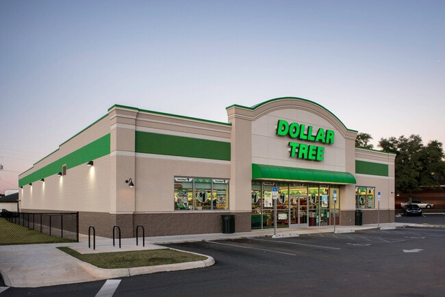
Property Record
Lincolnton Hwy, , NC


Property Detail
Lincolnton Hwy
Charlotte
LINCOLNTON HWY. LOT 1 PLAT BOOK 104 PAGE 013
Charlotte-Concord-Gastonia, NC-SC
GASTON
312590
North Carolina
Commercialnec
1
2025
1.46 AC
2025
Gaston County
9,984 SF
NEARBY LISTINGS FOR SALE OR LEASE
DEMOGRAPHICS near Lincolnton Hwy
1 mile
3 mile
5 mile
2025 Total Population
1,022
9,838
20,255
2030 Population
1,086
10,454
21,658
Pop Growth 2025-2030
+ 6.26%
+ 6.26%
+ 6.93%
Average Age
43
42
42
2025 Total Households
408
3,919
8,065
HH Growth 2025-2030
+ 6.62%
+ 6.48%
+ 7.10%
Median Household Inc
$69,090
$64,500
$60,193
Avg Household Size
2.40
2.40
2.40
2025 Avg HH Vehicles
2.00
2.00
2.00
Median Home Value
$289,999
$265,117
$269,925
Median Year Built
1984
1980
1983
Nearby Places
Map Layers
Map Styles
 Street
 Aerial
Transit
 Traffic
 Biking
Places
Listings with unknown addresses are not visible on the map
- Restaurants
- Banks
- Shops
- Fitness
- Groceries
PUBLIC TRANSPORTATION
AIRPORT
Charlotte/Douglas International
Drive
Walk
Distance
Charlotte/Douglas International
52 min
31.5 mi
Freight Ports
North Charleston Terminal
Drive
Walk
Distance
North Charleston Terminal
266 min
227.5 mi
SALE & LEASE HISTORY
LISTING DATE
SALE/LEASE

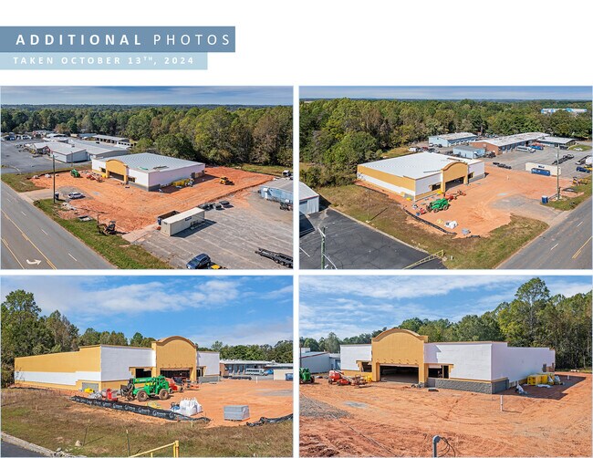
Oct 17, 2024
For Sale
Nearby Properties
Address
Land Use
TOTAL SIZE
Lot Size
Zoning
Address
Land Use
TOTAL SIZE
Lot Size
Zoning
151,003 SF
27.39 AC
SHOP5
Address
Land Use
TOTAL SIZE
Lot Size
Zoning
69,747 SF
18.33 AC
R1
Address
Land Use
TOTAL SIZE
Lot Size
Zoning
1,320 SF
72.60 AC
Address
Land Use
TOTAL SIZE
Lot Size
Zoning
92,928 SF
21.25 AC
PUB01
Address
Land Use
TOTAL SIZE
Lot Size
Zoning
38,904 SF
5.84 AC
HCAR4
Address
Land Use
TOTAL SIZE
Lot Size
Zoning
3,917 SF
3.43 AC
R2
Address
Land Use
TOTAL SIZE
Lot Size
Zoning
75,190 SF
10.69 AC
PUB01
Address
Land Use
TOTAL SIZE
Lot Size
Zoning
6,116 SF
52.31 AC
Address
Land Use
TOTAL SIZE
Lot Size
Zoning
18,300 SF
8.61 AC
Address
Land Use
TOTAL SIZE
Lot Size
Zoning
62,238 SF
17 AC
PUB01
Address
Land Use
TOTAL SIZE
Lot Size
Zoning
6,480 SF
12.98 AC
PUB01
Address
Land Use
TOTAL SIZE
Lot Size
Zoning
41,067 SF
2.42 AC
CHUR2
Address
Land Use
TOTAL SIZE
Lot Size
Zoning
97,650 SF
11.66 AC
INDS2
Address
Land Use
TOTAL SIZE
Lot Size
Zoning
35,044 SF
5.88 AC
CHUR2
Address
Land Use
TOTAL SIZE
Lot Size
Zoning
22,808 SF
2.67 AC
HCAR4
Address
Land Use
TOTAL SIZE
Lot Size
Zoning
46,361 SF
14.71 AC
STOR2
Address
Land Use
TOTAL SIZE
Lot Size
Zoning
6,975 SF
105.20 AC
R2
Address
Land Use
TOTAL SIZE
Lot Size
Zoning
7,702 SF
1.55 AC
OFF01
Address
Land Use
TOTAL SIZE
Lot Size
Zoning
24,098 SF
9.67 AC
OFF01
Address
Land Use
TOTAL SIZE
Lot Size
Zoning
768 SF
11.52 AC
APT01
Address
Land Use
TOTAL SIZE
Lot Size
Zoning
38,536 SF
10.20 AC
OFF01
Address
Land Use
TOTAL SIZE
Lot Size
Zoning
26,004 SF
12.35 AC
CHUR2
Address
Land Use
TOTAL SIZE
Lot Size
Zoning
13,881 SF
2.48 AC
GOV06
Address
Land Use
TOTAL SIZE
Lot Size
Zoning
1,430 SF
2.57 AC
APT01
Address
Land Use
TOTAL SIZE
Lot Size
Zoning
8,750 SF
203.17 AC
R-T
Address
Land Use
TOTAL SIZE
Lot Size
Zoning
20,046 SF
17.69 AC
CHUR2
Address
Land Use
TOTAL SIZE
Lot Size
Zoning
3,712 SF
2.33 AC
APT01
Address
Land Use
TOTAL SIZE
Lot Size
Zoning
3,811 SF
0.88 AC
REST1
Address
Land Use
TOTAL SIZE
Lot Size
Zoning
9,086 SF
1.72 AC
B-N
The World's #1 Commercial Real Estate Marketplace
Connect with us
© 2026 CoStar Group
The information above has been obtained from sources believed reliable. While we do not doubt its accuracy we have not verified it and make no guarantee, warranty or representation about it. It is your responsibility to independently confirm its accuracy and completeness. Any projections, opinions, assumptions, or estimates used are for example only and do not represent the current or future performance of the property. The value of this transaction to you depends on tax and other factors which should be evaluated by your tax, financial, and legal advisors. You and your advisors should conduct a careful, independent investigation of the property to determine to your satisfaction the suitability of the property for your needs.