Property Record
Lockhart St, Dublin, CA 94568
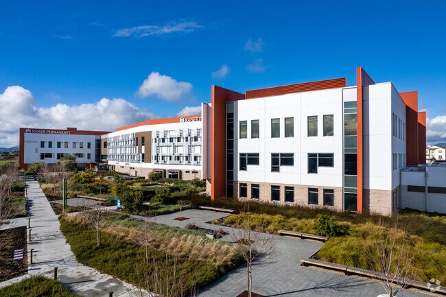

Property Detail
Lockhart St
985-0027-020-00
ALAMEDA
Medicalbuilding
California
AH Areas with a 1% annual chance of shallow flooding, usually in the form of a pond, withan average depth ranging from 1 to 3 feet. These areas have a 26% chance of flooding over the life of a 30-year mortgage.
13.23 AC
2024
Dublin
2025
East Bay/Oakland
450102
Oakland-Fremont-Berkeley, CA
213,957 SF
NEARBY LISTINGS FOR SALE OR LEASE
DEMOGRAPHICS near Lockhart St
1 mile
3 mile
5 mile
2025 Total Population
21,103
89,250
202,547
2030 Population
20,952
89,365
202,630
Pop Growth 2025-2030
(0.72%)
+ 0.13%
+ 0.04%
Average Age
39
39
40
2025 Total Households
7,185
29,645
69,239
HH Growth 2025-2030
(1.00%)
+ 0.04%
(0.01%)
Median Household Inc
$212,379
$194,032
$180,384
Avg Household Size
2.90
2.90
2.80
2025 Avg HH Vehicles
2.00
2.00
2.00
Median Home Value
$1,096,026
$1,107,167
$1,097,451
Median Year Built
2005
2000
1990
Nearby Places
Map Layers
Map Styles
 Street
 Aerial
Transit
 Traffic
 Biking
Places
Listings with unknown addresses are not visible on the map
- Restaurants
- Banks
- Shops
- Fitness
- Groceries
PUBLIC TRANSPORTATION
COMMUTER RAIL
Pleasanton Station (ACE Train - Altamont Corridor Express)
Drive
Walk
Distance
Pleasanton Station (ACE Train - Altamont Corridor Express)
12 min
4.8 mi
Livermore Station (ACE Train - Altamont Corridor Express)
Drive
Walk
Distance
Livermore Station (ACE Train - Altamont Corridor Express)
11 min
6.7 mi
AIRPORT
Metro Oakland International
Drive
Walk
Distance
Metro Oakland International
30 min
22.6 mi
Norman Y Mineta San Jose International
Drive
Walk
Distance
Norman Y Mineta San Jose International
44 min
33.5 mi
San Francisco International
Drive
Walk
Distance
San Francisco International
50 min
37.2 mi
Freight Ports
Port of Redwood City
Drive
Walk
Distance
Port of Redwood City
51 min
37.6 mi
Nearby Properties
Address
Land Use
TOTAL SIZE
Lot Size
Zoning
Address
Land Use
TOTAL SIZE
Lot Size
Zoning
789,398 SF
57.91 AC
Address
Land Use
TOTAL SIZE
Lot Size
Zoning
713,970 SF
23.48 AC
Address
Land Use
TOTAL SIZE
Lot Size
Zoning
674,847 SF
31.27 AC
Address
Land Use
TOTAL SIZE
Lot Size
Zoning
438,210 SF
17.81 AC
Address
Land Use
TOTAL SIZE
Lot Size
Zoning
249,319 SF
14.72 AC
Address
Land Use
TOTAL SIZE
Lot Size
Zoning
386,609 SF
33.36 AC
Address
Land Use
TOTAL SIZE
Lot Size
Zoning
486,976 SF
11.96 AC
Address
Land Use
TOTAL SIZE
Lot Size
Zoning
690,205 SF
20.44 AC
Address
Land Use
TOTAL SIZE
Lot Size
Zoning
312,669 SF
3.63 AC
Address
Land Use
TOTAL SIZE
Lot Size
Zoning
381,982 SF
17.54 AC
Address
Land Use
TOTAL SIZE
Lot Size
Zoning
306,815 SF
8.28 AC
Address
Land Use
TOTAL SIZE
Lot Size
Zoning
646,841 SF
38.83 AC
Address
Land Use
TOTAL SIZE
Lot Size
Zoning
335,523 SF
7.23 AC
Address
Land Use
TOTAL SIZE
Lot Size
Zoning
465,558 SF
14.56 AC
Address
Land Use
TOTAL SIZE
Lot Size
Zoning
393,931 SF
22.38 AC
Address
Land Use
TOTAL SIZE
Lot Size
Zoning
210,656 SF
11.36 AC
Address
Land Use
TOTAL SIZE
Lot Size
Zoning
315,764 SF
3 AC
Address
Land Use
TOTAL SIZE
Lot Size
Zoning
288,690 SF
0.10 AC
Address
Land Use
TOTAL SIZE
Lot Size
Zoning
367,734 SF
18.81 AC
Address
Land Use
TOTAL SIZE
Lot Size
Zoning
176,218 SF
6.39 AC
Address
Land Use
TOTAL SIZE
Lot Size
Zoning
239,112 SF
10.95 AC
Address
Land Use
TOTAL SIZE
Lot Size
Zoning
314,328 SF
2.91 AC
Address
Land Use
TOTAL SIZE
Lot Size
Zoning
372,220 SF
19.11 AC
Address
Land Use
TOTAL SIZE
Lot Size
Zoning
209,221 SF
7.16 AC
Address
Land Use
TOTAL SIZE
Lot Size
Zoning
199,932 SF
9.93 AC
Address
Land Use
TOTAL SIZE
Lot Size
Zoning
315,225 SF
10.13 AC
Address
Land Use
TOTAL SIZE
Lot Size
Zoning
300,597 SF
19.34 AC
Address
Land Use
TOTAL SIZE
Lot Size
Zoning
8,000 SF
58.49 AC
Address
Land Use
TOTAL SIZE
Lot Size
Zoning
163,322 SF
10.93 AC
Address
Land Use
TOTAL SIZE
Lot Size
Zoning
30.26 AC
The World's #1 Commercial Real Estate Marketplace
Connect with us
© 2026 CoStar Group
The information above has been obtained from sources believed reliable. While we do not doubt its accuracy we have not verified it and make no guarantee, warranty or representation about it. It is your responsibility to independently confirm its accuracy and completeness. Any projections, opinions, assumptions, or estimates used are for example only and do not represent the current or future performance of the property. The value of this transaction to you depends on tax and other factors which should be evaluated by your tax, financial, and legal advisors. You and your advisors should conduct a careful, independent investigation of the property to determine to your satisfaction the suitability of the property for your needs.