Property Record
Lone Star Rd, Mansfield, TX 76065
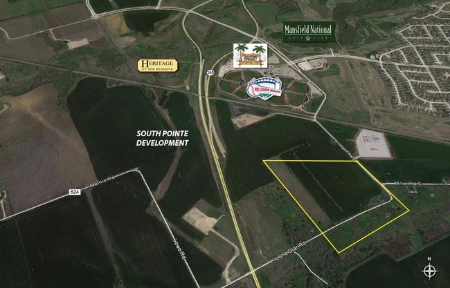

Property Detail
Lone Star Rd
Dallas-Fort Worth-Arlington, TX
385 M GREGG 19.1659 ACRES
201894
ELLIS
Agriculturalland
Texas
A Areas with a 1% annual chance of flooding and a 26% chance of flooding over the life of a 30-year mortgage.
15.81 AC
0
Ellis County
2025
Dallas/Ft Worth
060702
NEARBY LISTINGS FOR SALE OR LEASE
DEMOGRAPHICS near Lone Star Rd
1 mile
3 mile
5 mile
2025 Total Population
6,241
41,385
113,157
2030 Population
7,051
45,448
121,919
Pop Growth 2025-2030
+ 12.98%
+ 9.82%
+ 7.74%
Average Age
36
36
37
2025 Total Households
2,010
13,305
36,699
HH Growth 2025-2030
+ 13.33%
+ 10.06%
+ 7.95%
Median Household Inc
$135,137
$124,180
$115,470
Avg Household Size
3.10
3.10
3.00
2025 Avg HH Vehicles
2.00
2.00
2.00
Median Home Value
$456,528
$467,812
$413,160
Median Year Built
2010
2009
2006
Nearby Places
Map Layers
Map Styles
 Street
 Aerial
Transit
 Traffic
 Biking
Places
Listings with unknown addresses are not visible on the map
- Restaurants
- Banks
- Shops
- Fitness
- Groceries
PUBLIC TRANSPORTATION
AIRPORT
Dallas Love Field
Drive
Walk
Distance
Dallas Love Field
42 min
31.4 mi
Dallas-Fort Worth International
Drive
Walk
Distance
Dallas-Fort Worth International
47 min
35.3 mi
SALE & LEASE HISTORY
LISTING DATE
SALE/LEASE

Sep 24, 2016
For Sale
Oct 09, 2020
For Sale
Nearby Properties
Address
Land Use
TOTAL SIZE
Lot Size
Zoning
Address
Land Use
TOTAL SIZE
Lot Size
Zoning
427,771 SF
101.40 AC
Address
Land Use
TOTAL SIZE
Lot Size
Zoning
Address
Land Use
TOTAL SIZE
Lot Size
Zoning
176,817 SF
30.71 AC
Address
Land Use
TOTAL SIZE
Lot Size
Zoning
471,921 SF
46 AC
Address
Land Use
TOTAL SIZE
Lot Size
Zoning
740,870 SF
73.29 AC
Address
Land Use
TOTAL SIZE
Lot Size
Zoning
305,283 SF
14.75 AC
Address
Land Use
TOTAL SIZE
Lot Size
Zoning
Address
Land Use
TOTAL SIZE
Lot Size
Zoning
347,406 SF
20.99 AC
Address
Land Use
TOTAL SIZE
Lot Size
Zoning
108,054 SF
26.99 AC
Address
Land Use
TOTAL SIZE
Lot Size
Zoning
730,356 SF
44.50 AC
Address
Land Use
TOTAL SIZE
Lot Size
Zoning
222,600 SF
9.31 AC
Address
Land Use
TOTAL SIZE
Lot Size
Zoning
28,974 SF
47.07 AC
Address
Land Use
TOTAL SIZE
Lot Size
Zoning
98,001 SF
14.51 AC
Address
Land Use
TOTAL SIZE
Lot Size
Zoning
199,000 SF
7.76 AC
Address
Land Use
TOTAL SIZE
Lot Size
Zoning
70,066 SF
23.14 AC
Address
Land Use
TOTAL SIZE
Lot Size
Zoning
99,264 SF
10 AC
Address
Land Use
TOTAL SIZE
Lot Size
Zoning
90,377 SF
27.54 AC
Address
Land Use
TOTAL SIZE
Lot Size
Zoning
90,000 SF
12.20 AC
Address
Land Use
TOTAL SIZE
Lot Size
Zoning
117,457 SF
11.24 AC
Address
Land Use
TOTAL SIZE
Lot Size
Zoning
306,925 SF
19.44 AC
Address
Land Use
TOTAL SIZE
Lot Size
Zoning
54,224 SF
1.72 AC
Address
Land Use
TOTAL SIZE
Lot Size
Zoning
73,480 SF
295.63 AC
Address
Land Use
TOTAL SIZE
Lot Size
Zoning
1,864.30 AC
Address
Land Use
TOTAL SIZE
Lot Size
Zoning
160,775 SF
14.41 AC
Address
Land Use
TOTAL SIZE
Lot Size
Zoning
204,543 SF
5.11 AC
Address
Land Use
TOTAL SIZE
Lot Size
Zoning
117,249 SF
30.65 AC
Address
Land Use
TOTAL SIZE
Lot Size
Zoning
224,941 SF
27.71 AC
Address
Land Use
TOTAL SIZE
Lot Size
Zoning
118,641 SF
12.07 AC
Address
Land Use
TOTAL SIZE
Lot Size
Zoning
56,641 SF
4.77 AC
Address
Land Use
TOTAL SIZE
Lot Size
Zoning
52,386 SF
3.94 AC
The World's #1 Commercial Real Estate Marketplace
Connect with us
© 2026 CoStar Group
The information above has been obtained from sources believed reliable. While we do not doubt its accuracy we have not verified it and make no guarantee, warranty or representation about it. It is your responsibility to independently confirm its accuracy and completeness. Any projections, opinions, assumptions, or estimates used are for example only and do not represent the current or future performance of the property. The value of this transaction to you depends on tax and other factors which should be evaluated by your tax, financial, and legal advisors. You and your advisors should conduct a careful, independent investigation of the property to determine to your satisfaction the suitability of the property for your needs.